

Drygalski Glacier
Encyclopedia
Glacier
A glacier is a large persistent body of ice that forms where the accumulation of snow exceeds its ablation over many years, often centuries. At least 0.1 km² in area and 50 m thick, but often much larger, a glacier slowly deforms and flows due to stresses induced by its weight...
in Antarctica, located on the Scott Coast
Scott Coast
Scott Coast is that portion of the coast of Victoria Land between Cape Washington and Minna Bluff. Named by New Zealand Antarctic Place-Names Committee in 1961 after Captain Robert Falcon Scott, Royal Navy, leader of the Discovery expedition and the British Antarctic Expedition , who lost his...
, in the northern McMurdo Sound
McMurdo Sound
The ice-clogged waters of Antarctica's McMurdo Sound extend about 55 km long and wide. The sound opens into the Ross Sea to the north. The Royal Society Range rises from sea level to 13,205 feet on the western shoreline. The nearby McMurdo Ice Shelf scribes McMurdo Sound's southern boundary...
of Antarctica's Ross Dependency
Ross Dependency
The Ross Dependency is a region of Antarctica defined by a sector originating at the South Pole, passing along longitudes 160° east to 150° west, and terminating at latitude 60° south...
, 240 kilometres (149.1 mi) north of Ross Island
Ross Island
Ross Island is an island formed by four volcanoes in the Ross Sea near the continent of Antarctica, off the coast of Victoria Land in McMurdo Sound.-Geography:...
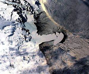
. The ice tongue
Ice tongue
An ice tongue is a long and narrow sheet of ice projecting out from the coastline. An ice tongue forms when a valley glacier moves very rapidly out into the ocean or a lake....
is located at 75°24′S 163°30′E. Drygalski Ice Tongue is stable by the standards of Antarctica's icefloes, and stretches 70 kilometres (43.5 mi) out to sea from the David Glacier
David Glacier
David Glacier is the most imposing outlet glacier in Victoria Land, Antarctica, fed by two main flows which drain an area larger than 200,000 square kilometres of the East Antarctic plateau, with an estimated ice discharge rate of 7.8 +/- 0.7 km³/year...
, reaching the sea from a valley in the Prince Albert Mountains
Prince Albert Mountains
The Prince Albert Mountains are a major mountain group in Antarctica over 320 km long. Located in Victoria Land, they run north-south between the Priestley and Ferrar glaicers....
of Victoria Land
Victoria Land
Victoria Land is a region of Antarctica bounded on the east by the Ross Ice Shelf and the Ross Sea and on the west by Oates Land and Wilkes Land. It was discovered by Captain James Clark Ross in January 1841 and named after the UK's Queen Victoria...
. Drygalski Ice Tongue ranges from 14 to 24 km (8.7 to 14.9 mi) wide.
Captain Robert Falcon Scott
Robert Falcon Scott
Captain Robert Falcon Scott, CVO was a Royal Navy officer and explorer who led two expeditions to the Antarctic regions: the Discovery Expedition, 1901–04, and the ill-fated Terra Nova Expedition, 1910–13...
, leader of the British National Antarctic Expedition (BrNAE) (1901-1904), discovered Drygalski Ice Tongue in January 1902 and named it for Prof. Erich von Drygalski
Erich von Drygalski
Erich Dagobert von Drygalski was a German geographer, geophysicist and polar scientist, born in Königsberg, Province of Prussia....
, a contemporary German explorer then in Antarctica. Drygalski Ice Tongue became well established by the name Drygalski Ice Tongue before it became usual to give the same name to a glacier and its glacier tongue. Although this feature is a glacier tongue, the generic term ice tongue has been retained in the name to reduce ambiguity.
Drygalski Ice Tongue is thought to be at least 4,000 years old.
On March-April 2005, a 3000 square kilometres (1,158.3 sq mi) iceberg designated B-15A
Iceberg B-15
Iceberg B-15 is one of the world's largest recorded icebergs. It measured around 295 km long and 37 km wide , with a surface area of 11,000 km² larger than the island of Jamaica. The mass was estimated around three billion tonnes...
hit the ice tongue breaking off two pieces, each with a surface of about 70 square kilometres (27 sq mi). This iceberg is a remnant of Iceberg B-15
Iceberg B-15
Iceberg B-15 is one of the world's largest recorded icebergs. It measured around 295 km long and 37 km wide , with a surface area of 11,000 km² larger than the island of Jamaica. The mass was estimated around three billion tonnes...
, which calved
Ice calving
Ice calving, also known as glacier calving or iceberg calving, is a form of ice ablation or ice disruption. It is the sudden release and breaking away of a mass of ice from a glacier, iceberg, ice front, ice shelf, or crevasse...
from the Ross Ice Shelf
Ross Ice Shelf
The Ross Ice Shelf is the largest ice shelf of Antarctica . It is several hundred metres thick. The nearly vertical ice front to the open sea is more than 600 km long, and between 15 and 50 metres high above the water surface...
in 2000. Scientists are also concerned for several penguin
Penguin
Penguins are a group of aquatic, flightless birds living almost exclusively in the southern hemisphere, especially in Antarctica. Highly adapted for life in the water, penguins have countershaded dark and white plumage, and their wings have become flippers...
colonies which have been isolated from the open sea by the two large bodies of ice.
At the end of March 2006, another iceberg coming from the Ross Ice Shelf
Ross Ice Shelf
The Ross Ice Shelf is the largest ice shelf of Antarctica . It is several hundred metres thick. The nearly vertical ice front to the open sea is more than 600 km long, and between 15 and 50 metres high above the water surface...
, named C-16, hit the ice tongue breaking off a large additional piece (more than 100 square kilometres or 38.6 sq mi).
See also
- List of glaciers in the Antarctic
- Erebus Ice TongueErebus Ice TongueThe Erebus Ice Tongue is a mountain outlet glacier that projects 11–12 km into McMurdo Sound from the Ross Island coastline near Cape Evans, Antarctica. The glacier tongue varies in thickness from 50 m at the snout to 300 m at the point where it is grounded on the shoreline. Explorers from...
- List of glaciers
- McMurdo SoundMcMurdo SoundThe ice-clogged waters of Antarctica's McMurdo Sound extend about 55 km long and wide. The sound opens into the Ross Sea to the north. The Royal Society Range rises from sea level to 13,205 feet on the western shoreline. The nearby McMurdo Ice Shelf scribes McMurdo Sound's southern boundary...