Dugdale Glacier
Encyclopedia
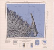
Dugdale Glacier is a glacier
about 46 km long, draining northeast from the Admiralty Mountains
into Robertson Bay
on the north coast of Victoria Land
. It flows along the west side of Geikie Ridge
before coalescing with Murray Glacier
just west of Duke of York Island
. Charted by British Antarctic Expedition 1898-1900
, under Carsten Borchgrevink, who named it for Frank Dugdale of Snitterfield, Stratford-on-Avon.

Glacier
A glacier is a large persistent body of ice that forms where the accumulation of snow exceeds its ablation over many years, often centuries. At least 0.1 km² in area and 50 m thick, but often much larger, a glacier slowly deforms and flows due to stresses induced by its weight...
about 46 km long, draining northeast from the Admiralty Mountains
Admiralty Mountains
The Admiralty Mountains is a large group of high mountains and individually-named ranges and ridges in northeastern Victoria Land of Antarctica...
into Robertson Bay
Robertson Bay
Robertson Bay is a large, roughly triangular bay that indents the north coast of Victoria Land between Cape Barrow and Cape Adare. Discovered in 1841 by Captain James Clark Ross, Royal Navy, who named it for Dr. John Robertson, Surgeon on the HMS Terror....
on the north coast of Victoria Land
Victoria Land
Victoria Land is a region of Antarctica bounded on the east by the Ross Ice Shelf and the Ross Sea and on the west by Oates Land and Wilkes Land. It was discovered by Captain James Clark Ross in January 1841 and named after the UK's Queen Victoria...
. It flows along the west side of Geikie Ridge
Geikie Ridge
Geikie Ridge is a massive mountain ridge, 20 nautical miles long and 6 nautical miles wide, forming the divide between Dugdale Glacier and Murray Glacier in the Admiralty Mountains of Victoria Land, Antarctica...
before coalescing with Murray Glacier
Murray Glacier
Murray Glacier is a valley glacier, long, draining seaward along the east side of Geikie Ridge in the Admiralty Mountains. Its terminus coalesces with that of Dugdale Glacier where both glaciers discharge into Robertson Bay along the north coast of Victoria Land...
just west of Duke of York Island
Duke of York Island, Antarctica
Duke of York Island is a mountainous ice-free island, 2.5 miles long, lying in the southern part of Robertson Bay, along the northern coast of Victoria Land. It was first charted in 1899 by the Southern Cross Expedition, under Carstens Borchgrevink, who named it for the Duke of York, later George V....
. Charted by British Antarctic Expedition 1898-1900
Southern Cross Expedition
The Southern Cross Expedition, officially known as the British Antarctic Expedition 1898–1900, was the first British venture of the Heroic Age of Antarctic Exploration, and the forerunner of the more celebrated journeys of Robert Falcon Scott and Ernest Shackleton...
, under Carsten Borchgrevink, who named it for Frank Dugdale of Snitterfield, Stratford-on-Avon.


