.gif)
Eastern Parkway (Brooklyn)
Encyclopedia


Boulevard
A Boulevard is type of road, usually a wide, multi-lane arterial thoroughfare, divided with a median down the centre, and roadways along each side designed as slow travel and parking lanes and for bicycle and pedestrian usage, often with an above-average quality of landscaping and scenery...
that runs through a portion of the New York City
New York City
New York is the most populous city in the United States and the center of the New York Metropolitan Area, one of the most populous metropolitan areas in the world. New York exerts a significant impact upon global commerce, finance, media, art, fashion, research, technology, education, and...
borough
Borough (New York City)
New York City, one of the largest cities in the world, is composed of five boroughs. Each borough now has the same boundaries as the county it is in. County governments were dissolved when the city consolidated in 1898, along with all city, town, and village governments within each county...
of Brooklyn
Brooklyn
Brooklyn is the most populous of New York City's five boroughs, with nearly 2.6 million residents, and the second-largest in area. Since 1896, Brooklyn has had the same boundaries as Kings County, which is now the most populous county in New York State and the second-most densely populated...
. The road begins at Grand Army Plaza and extends east, running parallel to Atlantic Avenue
Atlantic Avenue (New York City)
Atlantic Avenue is an important street in the New York City boroughs of Brooklyn and Queens. It stretches from the Brooklyn waterfront on the East River all the way to Jamaica, Queens...
, along the crest of the moraine
Moraine
A moraine is any glacially formed accumulation of unconsolidated glacial debris which can occur in currently glaciated and formerly glaciated regions, such as those areas acted upon by a past glacial maximum. This debris may have been plucked off a valley floor as a glacier advanced or it may have...
that separates northern from southern Long Island, to Ralph Avenue. There, it turns to the northeast, still following the moraine, until it terminates at Evergreen Cemetery
Cemetery of the Evergreens, Brooklyn
The Cemetery of the Evergreens is a non-denominational cemetery in Brooklyn and Queens, New York, colloquially called Evergreen Cemetery. It was incorporated in 1849, not long after the passage of New York's Rural Cemetery Act spurred development of cemeteries outside Manhattan. For a time, it was...
where the moraine takes a steep climb towards a peak at Ridgewood Reservoir
Ridgewood Reservoir
Ridgewood Reservoir is a decommissioned 19th century reservoir that sits on the Brooklyn-Queens border and is part of Highland Park. The reservoir and park are bounded on the north by the Jackie Robinson Parkway, on the south by Highland Boulevard, on the west by Vermont Place and on the east by...
.
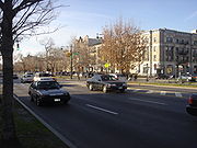
In the short westernmost portion, between Grand Army Plaza and Washington Avenue, the thoroughfare consists of a broad, bidirectional avenue of six lanes, separated by a median from a narrow parallel side street on the north side. The section between Washington and Ralph Avenues has also a southern side street, separated by another median
Tree lawn
A road verge, is a narrow strip of grass or plants and sometimes also trees typically located beside the carriageway within the boundary of a road.The land is often public...
. Both medians have trees, benches, subway stations, and paths for pedestrians. The southern one has a bike path
Cycling in New York City
New York City offers a mix of favorable cycling conditions — dense urban proximities, short distances and relatively flat terrain — along with significant cycling challenges: congested roadways with stop and go traffic, a sometimes unsympathetic regulatory environment, and streets with...
, part of the Brooklyn-Queens Greenway
Brooklyn-Queens Greenway
The Brooklyn-Queens Greenway is a bicycling and pedestrian path connecting parks and roads in the New York City boroughs of Brooklyn and Queens, connecting Coney Island in the south to Fort Totten in the north, on Long Island Sound...
which runs south from the western end through Prospect Park to Ocean Parkway
Ocean Parkway (Brooklyn)
Ocean Parkway is a broad boulevard in the west central portion of the borough of Brooklyn in New York City.-Route description:Ocean Parkway extends over a distance of about five miles , running almost north to south from the vicinity of Prospect Park to Brighton Beach...
and east from the eastern end through Forest Park (Queens)
Forest Park (Queens)
Forest Park is a park in the New York City borough of Queens. It has an area of 538 acres . The park is operated and maintained by the New York City Department of Parks and Recreation.-History:...
. East of Ralph Avenue, the parkway
Parkway
The term parkway has several distinct principal meanings and numerous synonyms around the world, for either a type of landscaped area or a type of road.Type of landscaped area:...
is reduced to four lanes, heading in a northeasterly direction towards the Jackie Robinson Parkway
Jackie Robinson Parkway
The Jackie Robinson Parkway is a parkway in the New York City boroughs of Brooklyn and Queens. The western terminus of the parkway is at Jamaica Avenue in the Brooklyn neighborhood of East New York. It runs through Highland Park, along the north side of Ridgewood Reservoir, and through Forest Park...
.
According to the New York City Department of Parks and Recreation
New York City Department of Parks and Recreation
The City of New York Department of Parks & Recreation is the department of government of the City of New York responsible for maintaining the city's parks system, preserving and maintaining the ecological diversity of the city's natural areas, and furnishing recreational opportunities for city's...
's description of Eastern Parkway:
The world's first parkway was conceived by Frederick Law OlmstedFrederick Law OlmstedFrederick Law Olmsted was an American journalist, social critic, public administrator, and landscape designer. He is popularly considered to be the father of American landscape architecture, although many scholars have bestowed that title upon Andrew Jackson Downing...
and Calvert VauxCalvert VauxCalvert Vaux , was an architect and landscape designer. He is best remembered as the co-designer , of New York's Central Park....
in 1866. The term parkwayParkwayThe term parkway has several distinct principal meanings and numerous synonyms around the world, for either a type of landscaped area or a type of road.Type of landscaped area:...
was coined by these designers as a landscaped road built expressly for 'pleasure-ridingPleasure ridingPleasure riding is a form of equestrianism that encompasses many forms of recreational riding for personal enjoyment, absent elements of competition. Pleasure riding is called "hacking" in British English, and in parts of the eastern United States and Canada...
and driving' or scenic access to Prospect ParkProspect Park (Brooklyn)Prospect Park is a 585-acre public park in the New York City borough of Brooklyn located between Park Slope, Prospect-Lefferts Gardens, Kensington, Windsor Terrace and Flatbush Avenue, Grand Army Plaza and the Brooklyn Botanic Garden...
(also designed by Olmsted and Vaux). To these ends, commerce was restricted. The parkway was constructed from Grand Army Plaza to Ralph Avenue (the boundary of the City of Brooklyn) between 1870 and 1874. Olmsted and Vaux intended Eastern Parkway to be the Brooklyn nucleus of an interconnected park and parkway system for the New York area. The plan was never completed but their idea of bringing the countryside into the city influenced the construction of major parks and parkways in cities throughout the United States.
The success of the special statutory commercial restrictions on this and other urban parkways inspired later, more general zoning
Zoning
Zoning is a device of land use planning used by local governments in most developed countries. The word is derived from the practice of designating permitted uses of land based on mapped zones which separate one set of land uses from another...
schemes in New York and elsewhere. The parkway was planned as an important urban design element to create an amenity for a good neighborhood.
Like some later roads on Long Island
Long Island
Long Island is an island located in the southeast part of the U.S. state of New York, just east of Manhattan. Stretching northeast into the Atlantic Ocean, Long Island contains four counties, two of which are boroughs of New York City , and two of which are mainly suburban...
, Eastern Parkway was designed to use land that was idle because it was high, rocky, and unsuited to farming. The presence of the road, however, made the area residentially desirable for people whose income derived from elsewhere. Thus it became inhabited in the next few decades, while land on slopes to the south and north continued to be used for farms into the 20th century, when the IRT Eastern Parkway Line
IRT Eastern Parkway Line
IRT Eastern Parkway Line and New Lots Line can refer to:* IRT Eastern Parkway Line* IRT New Lots Line...
subway was built under the parkway. Many trees along the parkway bear plaques commemorating soldiers fallen in World War I.
In addition to Grand Army Plaza and Prospect Park, other attractions and notable buildings along Eastern Parkway include the Brooklyn Public Library
Brooklyn Public Library
The Brooklyn Public Library is the public library system of the borough of Brooklyn in New York City. It is the fifth largest public library system in the United States. Like the two other public library systems in New York City, it is an independent nonprofit organization that is funded by the...
central branch, the Brooklyn Museum
Brooklyn Museum
The Brooklyn Museum is an encyclopedia art museum located in the New York City borough of Brooklyn. At 560,000 square feet, the museum holds New York City's second largest art collection with roughly 1.5 million works....
, the Brooklyn Botanical Gardens, 770 Eastern Parkway
770 Eastern Parkway
770 Eastern Parkway is the street address of the central headquarters of the Chabad-Lubavitch Hasidic movement, located on Eastern Parkway in the Crown Heights section of Brooklyn, New York, in the United States of America...
, Zion Triangle
Zion Triangle
Zion Park is a small park in the Brownsville, Brooklyn section of Brooklyn, New York notable for the Brownsville War Memorial.The Memorial to the fallen of the First World War was created by sculptor Charles Cary Rumsey and dedicated in 1925...
and the Jewish Children's Museum
Jewish Children's Museum
The Jewish Children's Museum is the largest Jewish-themed children's museum in the United States. It aims for children of all faiths and backgrounds to gain a positive perspective and awareness of the Jewish heritage, fostering tolerance and understanding...
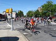
. The parkway is the route of the West Indian Day Parade, a festive annual celebration taking place around Labor Day.
Route description
Starting from Grand Army Plaza, where it intersects with Flatbush and Vanderbilt Avenues, as well as Prospect Park West, the Eastern Parkway heads east, passing the Brooklyn Museum and Washington Avenue. It then passes BedfordBedford Avenue (Brooklyn)
Bedford Avenue is the longest street in Brooklyn, New York City, stretching and 132 blocks from Greenpoint south to Sheepshead Bay, and passing through the neighborhoods of Williamsburg, Bedford-Stuyvesant, Crown Heights, Flatbush and Midwood....
, Rogers, and Nostrand Avenue
Nostrand Avenue
Nostrand Avenue is a major street in Brooklyn, New York, that runs north from Emmons Avenue in Sheepshead Bay to Flushing Avenue in Williamsburg, where it continues as Lee Avenue. From Flushing Avenue to Farragut Road, Nostrand Avenue is a two-lane street...
s before passing the Jewish Children's Museum in Crown Heights. It continues east, crossing Utica and Howard Avenues, and then Atlantic Avenue. It then ends at Broadway, and the Eastern Parkway Extension continues a block north to Bushwick Avenue, near Knollwood Park Cemetery.

