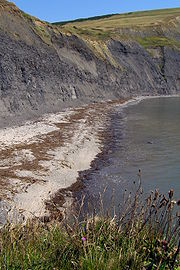
Egmont Bight
Encyclopedia

Dorset
Dorset , is a county in South West England on the English Channel coast. The county town is Dorchester which is situated in the south. The Hampshire towns of Bournemouth and Christchurch joined the county with the reorganisation of local government in 1974...
, England
England
England is a country that is part of the United Kingdom. It shares land borders with Scotland to the north and Wales to the west; the Irish Sea is to the north west, the Celtic Sea to the south west, with the North Sea to the east and the English Channel to the south separating it from continental...
.
Geology
The bay exposes good sections of Upper Kimmeridge shale and mudstone, with some bituminous shaleBituminous shale
Bituminous shale is an argillaceous shale impregnated with bitumen, often accompanying coal. It may contain kerogen; in that case it is classified as oil shale. When carbonaceous material is present in large amounts, bituminous shale grades into bituminous coal...
and some small calcareous nodules.
On foot the stony beach is only accessible at low tide by walking 1 kilometre (0.621372736649807 mi) west around Egmont Point from the beach at Chapman's Pool. There is no safe route down from the clifftop coast path
South West Coast Path
The South West Coast Path is Britain's longest waymarked long-distance footpath and a National Trail. It stretches for , running from Minehead in Somerset, along the coasts of Devon and Cornwall, to Poole Harbour in Dorset. Since it rises and falls with every river mouth, it is also one of the more...
, across Houns-tout cliff, nor around the Freshwater Steps promontory at the beach's western end.
The Jurassic Coast
Jurassic Coast
The Jurassic Coast is a World Heritage Site on the English Channel coast of southern England. The site stretches from Orcombe Point near Exmouth in East Devon to Old Harry Rocks near Swanage in East Dorset, a distance of ....
stretches over a distance of 153 kilometres (95 mi), from Orcombe Point
Orcombe Point
Orcombe Point is a coastal feature near Exmouth, Devon, on the south coast of England. It lies about south of the city of Exeter, southeast of Exmouth town centre and about southwest of Sidmouth....
near Exmouth
Exmouth, Devon
Exmouth is a port town, civil parish and seaside resort in East Devon, England, sited on the east bank of the mouth of the River Exe. In 2001, it had a population of 32,972.-History:...
, in the west, to Old Harry Rocks
Old Harry Rocks
The Old Harry Rocks are two chalk sea stacks located at Handfast Point, on the Isle of Purbeck in Dorset, southern England.- Location :Old Harry Rocks lie directly east of Studland, about 4 kilometres northeast of Swanage, and about 10 kilometres south of the large towns of Poole and...
on the Isle of Purbeck
Isle of Purbeck
The Isle of Purbeck, not a true island but a peninsula, is in the county of Dorset, England. It is bordered by the English Channel to the south and east, where steep cliffs fall to the sea; and by the marshy lands of the River Frome and Poole Harbour to the north. Its western boundary is less well...
, in the east. The coastal exposures along the coastline provide a continuous sequence of Triassic
Triassic
The Triassic is a geologic period and system that extends from about 250 to 200 Mya . As the first period of the Mesozoic Era, the Triassic follows the Permian and is followed by the Jurassic. Both the start and end of the Triassic are marked by major extinction events...
, Jurassic
Jurassic
The Jurassic is a geologic period and system that extends from about Mya to Mya, that is, from the end of the Triassic to the beginning of the Cretaceous. The Jurassic constitutes the middle period of the Mesozoic era, also known as the age of reptiles. The start of the period is marked by...
and Cretaceous
Cretaceous
The Cretaceous , derived from the Latin "creta" , usually abbreviated K for its German translation Kreide , is a geologic period and system from circa to million years ago. In the geologic timescale, the Cretaceous follows the Jurassic period and is followed by the Paleogene period of the...
rock formations spanning approximately 185 million years of the Earths history. The localities along the Jurassic Coast includes a large range of important fossil
Fossil
Fossils are the preserved remains or traces of animals , plants, and other organisms from the remote past...
zones.
See also
- List of places on the Jurassic Coast
- List of Dorset beaches
- Jurassic CoastJurassic CoastThe Jurassic Coast is a World Heritage Site on the English Channel coast of southern England. The site stretches from Orcombe Point near Exmouth in East Devon to Old Harry Rocks near Swanage in East Dorset, a distance of ....

