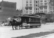
Eighth Avenue Line (Manhattan surface)
Encyclopedia

Manhattan
Manhattan is the oldest and the most densely populated of the five boroughs of New York City. Located primarily on the island of Manhattan at the mouth of the Hudson River, the boundaries of the borough are identical to those of New York County, an original county of the state of New York...
, New York City
New York City
New York is the most populous city in the United States and the center of the New York Metropolitan Area, one of the most populous metropolitan areas in the world. New York exerts a significant impact upon global commerce, finance, media, art, fashion, research, technology, education, and...
, United States
United States
The United States of America is a federal constitutional republic comprising fifty states and a federal district...
, running mostly along Eighth Avenue
Eighth Avenue (Manhattan)
Eighth Avenue is a north-south avenue on the West Side of Manhattan in New York City, carrying northbound traffic. Eighth Avenue begins in the West Village neighborhood at Abingdon Square and runs north for 44 blocks through Chelsea, the Garment District, Hell's Kitchen's east end, Midtown and the...
from Lower Manhattan
Lower Manhattan
Lower Manhattan is the southernmost part of the island of Manhattan, the main island and center of business and government of the City of New York...
to Harlem. Originally a streetcar line, it is now the M10 bus route and the M20 bus route, operated by the New York City Transit Authority
New York City Transit Authority
The New York City Transit Authority is a public authority in the U.S. state of New York that operates public transportation in New York City...
. The M10 bus now only runs north of 57th Street (near Columbus Circle
Columbus Circle
Columbus Circle, named for Christopher Columbus, is a major landmark and point of attraction in the New York City borough of Manhattan, located at the intersection of Eighth Avenue, Broadway, Central Park South , and Central Park West, at the southwest corner of Central Park. It is the point from...
), and the M20 runs south of 65 street.
History
The Eighth Avenue Railroad opened the line from the north end of the trackage shared with the Sixth Avenue Railroad's Sixth Avenue LineSixth Avenue Line (Manhattan surface)
The Sixth Avenue Line was a public transit line in Manhattan, New York City, United States, running mostly along Sixth Avenue from Lower Manhattan to Central Park...
at Canal Street
Canal Street (Manhattan)
Canal Street is a major street in New York City, crossing lower Manhattan to join New Jersey in the west to Brooklyn in the east . It forms the main spine of Chinatown, and separates it from Little Italy...
and Varick Street along Canal Street, Hudson Street
Hudson Street (Manhattan)
Hudson Street is a north/south oriented street in the New York City borough of Manhattan. Running from TriBeCa to Greenwich Village and through Hudson Square, Hudson Street has two distinct one-way traffic patterns that meet at Abingdon Square, at the street's intersection with Eighth Avenue and...
, and Eighth Avenue to 51st Street
51st Street (Manhattan)
51st Street is a long one-way street traveling east to west across Midtown Manhattan.-East 51st Street:*The route officially begins at Beekman Place which is on a hill overlooking FDR Drive...
on August 30, 1852. It was eventually extended north to 159th Street, with a branch along Macomb's Lane to 154th Street, and another branch to the south along Canal Street east to Broadway. Buses were substituted for streetcars by the Eighth Avenue Coach Corporation in March 1936. The New York City Omnibus Corporation took over operations in 1951, and in 1956 it was renamed Fifth Avenue Coach Lines; the Manhattan and Bronx Surface Transit Operating Authority
Manhattan and Bronx Surface Transit Operating Authority
The Manhattan and Bronx Surface Transit Operating Authority is a subsidiary of the New York City Transit Authority that was created in 1962 to take over bus services from the bankrupt Fifth Avenue Coach Company and Surface Transit, Inc...
replaced it in 1962.

