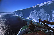
Ekstrom Ice Shelf
Encyclopedia

Sorasen Ridge
Sorasen Ridge is a broad snow covered ridge that separates the Quar and Ekstrom Ice shelves, on the coast of Queen Maud Land. The feature was first mapped and named Søråsen by the Norwegian-British-Swedish Antarctic Expedition , 1949-52....
and Halvfarryggen Ridge
Halvfarryggen Ridge
Halvfarryggen Ridge is a broad snow-covered ridge separating the Ekstrom and Jelbart Ice Shelves, on the coast of Queen Maud Land. First mapped by the Norwegian-British-Swedish Antarctic Expedition , 1949-52. They referred to the feature as "Isrygg" , but it was subsequently named Halvfarryggen ...
, on Princess Martha Coast
Princess Martha Coast
Princess Martha Coast is that portion of the coast of Queen Maud Land lying between 05° E and the terminus of Stancomb-Wills Glacier, at 20° W. The entire coastline is bounded by ice shelves with ice cliffs 20 to 35 m high....
of Queen Maud Land
Queen Maud Land
Queen Maud Land is a c. 2.7 million-square-kilometre region of Antarctica claimed as a dependent territory by Norway. The territory lies between 20° west and 45° east, between the British Antarctic Territory to the west and the Australian Antarctic Territory to the east. The latitudinal...
. It occupies an area of 8,700 km². It was first mapped by the Norwegian-British-Swedish Antarctic Expedition
Norwegian-British-Swedish Antarctic Expedition
Norwegian–British–Swedish Antarctic Expedition the first Antarctica expedition involving an international team of scientists...
(NBSAE) (1949–1952), and named for Bertil Ekström, a Swedish mechanical engineer with NBSAE, who drowned when the weasel (track-driven vehicle) he was driving plunged over the edge of Quar Ice Shelf
Quar Ice Shelf
Quar Ice Shelf is the ice shelf between Cape Norvegia and Sorasen Ridge along the coast of Queen Maud Land.-Discovery and Naming:It was mapped by the Norwegian-British-Swedish Antarctic Expedition...
on February 24, 1951.
Ekstrom Ice Shelf is 160 meters thick at the edge, and rises 15 meters above the sea level. Germany's Neumayer-Station III
Neumayer-Station III
Neumayer-Station III, also known as Neumayer III after geophysicist Georg von Neumayer, is a German South pole research station of the Alfred-Wegener-Institut in the Antarctic. It is located on the approximately 200-metre thick Ekstrom Ice Shelf several kilometres south of Neumayer-Station II. The...
is in the northeast at Atka Bay.

