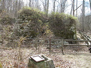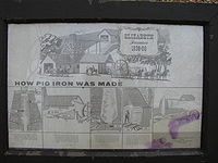
Elizabeth Furnace
Encyclopedia

Blast furnace
A blast furnace is a type of metallurgical furnace used for smelting to produce industrial metals, generally iron.In a blast furnace, fuel and ore and flux are continuously supplied through the top of the furnace, while air is blown into the bottom of the chamber, so that the chemical reactions...
in the Shenandoah Valley
Shenandoah Valley
The Shenandoah Valley is both a geographic valley and cultural region of western Virginia and West Virginia in the United States. The valley is bounded to the east by the Blue Ridge Mountains, to the west by the eastern front of the Ridge-and-Valley Appalachians , to the north by the Potomac River...
that was used to create pig iron
Pig iron
Pig iron is the intermediate product of smelting iron ore with a high-carbon fuel such as coke, usually with limestone as a flux. Charcoal and anthracite have also been used as fuel...
from 1836 – 1888 using Passage Creek
Passage Creek
Passage Creek is a tributary stream of the North Fork Shenandoah River in Fort Valley, Virginia. For most of its length it flows through a rural valley between the two spine-like ridges of Massanutten Mountain, then exits the valley by cutting a narrow gorge through the northeast end of the...
for water power. Iron ore was mined nearby, purified in the furnace, and then pig iron was transported over the Massanutten Mountain
Massanutten Mountain
Massanutten Mountain is a synclinal ridge in the Ridge-and-Valley Appalachians, located in the U.S. state of Virginia.-Geography:The mountain bisects the Shenandoah Valley just east of Strasburg in Shenandoah County in the north, to its highest peak east of Harrisonburg in Rockingham County in the...
to the South Fork of the Shenandoah River
Shenandoah River
The Shenandoah River is a tributary of the Potomac River, long with two forks approximately long each, in the U.S. states of Virginia and West Virginia...
for forging in Harpers Ferry, West Virginia
Harpers Ferry, West Virginia
Harpers Ferry is a historic town in Jefferson County, West Virginia, United States. In many books the town is called "Harper's Ferry" with an apostrophe....
. The road used to transport this iron is still used today by hikers climbing to the top of the Massanutten Mountain via the Massanutten Trail
Massanutten Trail
The Massanutten Trail is a National Recreation Trail located in George Washington National Forest in Central Virginia. Much of the path is steep and rugged terrain, and presents many mountain vistas. The trail traverses the Massanutten Range around its inner valley...
. Much of the original stone structure still exists, as well as a restored cabin, and an outdoor recreation area.
Elizabeth Furnace Recreation Area
The Elizabeth Furnace Recreation Area, located in George Washington National Forest just north of Fort ValleyFort Valley, Virginia
Fort Valley is a mountain valley in Shenandoah County, Virginia. The so-called "valley within a valley" lies between the two arms of the northern Massanutten Mountain range in the Shenandoah Valley. The valley is closed at both ends Fort Valley is a mountain valley in Shenandoah County, Virginia....
, Virginia
Virginia
The Commonwealth of Virginia , is a U.S. state on the Atlantic Coast of the Southern United States. Virginia is nicknamed the "Old Dominion" and sometimes the "Mother of Presidents" after the eight U.S. presidents born there...
, consists of three main areas: the group camping area, the picnic area and the family camping area.
The group camping area, located at 38.932424°N 78.321168°W, includes fire rings and open pit toilets.

Massanutten Trail
The Massanutten Trail is a National Recreation Trail located in George Washington National Forest in Central Virginia. Much of the path is steep and rugged terrain, and presents many mountain vistas. The trail traverses the Massanutten Range around its inner valley...
/ Tuscarora Trail
Tuscarora Trail
The Tuscarora Trail is a long-distance hiking trail that is under development. It splits off from the Appalachian Trail in Shenandoah National Park in Virginia, passes through West Virginia and Maryland, then rejoins the Appalachian Trail near Marysville, Pennsylvania...
), mountain biking trails and fishing in Passage Creek
Passage Creek
Passage Creek is a tributary stream of the North Fork Shenandoah River in Fort Valley, Virginia. For most of its length it flows through a rural valley between the two spine-like ridges of Massanutten Mountain, then exits the valley by cutting a narrow gorge through the northeast end of the...
. There is a trout hatchery near Passage Creek where a fishing license is required.
The family camping area, located at 38.924514°N 78.332201°W, includes 33 first-come, first-served pay camp sites, fire rings, and a restored 1830s cabin.

