Embarras River
Encyclopedia

Tributary
A tributary or affluent is a stream or river that flows into a main stem river or a lake. A tributary does not flow directly into a sea or ocean...
of the Wabash River
Wabash River
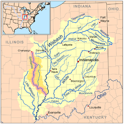
The Wabash River is a river in the Midwestern United States that flows southwest from northwest Ohio near Fort Recovery across northern Indiana to southern Illinois, where it forms the Illinois-Indiana border before draining into the Ohio River, of which it is the largest northern tributary...
in southeastern Illinois
Illinois
Illinois is the fifth-most populous state of the United States of America, and is often noted for being a microcosm of the entire country. With Chicago in the northeast, small industrial cities and great agricultural productivity in central and northern Illinois, and natural resources like coal,...
in the United States
United States
The United States of America is a federal constitutional republic comprising fifty states and a federal district...
. The waters of the Embarras reach the Gulf of Mexico
Gulf of Mexico
The Gulf of Mexico is a partially landlocked ocean basin largely surrounded by the North American continent and the island of Cuba. It is bounded on the northeast, north and northwest by the Gulf Coast of the United States, on the southwest and south by Mexico, and on the southeast by Cuba. In...
via the Wabash, Ohio
Ohio River
The Ohio River is the largest tributary, by volume, of the Mississippi River. At the confluence, the Ohio is even bigger than the Mississippi and, thus, is hydrologically the main stream of the whole river system, including the Allegheny River further upstream...
, and Mississippi
Mississippi River
The Mississippi River is the largest river system in North America. Flowing entirely in the United States, this river rises in western Minnesota and meanders slowly southwards for to the Mississippi River Delta at the Gulf of Mexico. With its many tributaries, the Mississippi's watershed drains...
rivers. The river drains a watershed
Drainage basin
A drainage basin is an extent or an area of land where surface water from rain and melting snow or ice converges to a single point, usually the exit of the basin, where the waters join another waterbody, such as a river, lake, reservoir, estuary, wetland, sea, or ocean...
of approximately 1566450 acre in an agricultural
Agriculture
Agriculture is the cultivation of animals, plants, fungi and other life forms for food, fiber, and other products used to sustain life. Agriculture was the key implement in the rise of sedentary human civilization, whereby farming of domesticated species created food surpluses that nurtured the...
region. The name comes from French explorers, who used the term embarras for river obstacles, blockages, and difficulties relating to logjams and the like.
Course

Champaign County, Illinois
Champaign County is a county located in the U.S. state of Illinois. According to the 2010 census, it has a population of 201,081, which is an increase of 11.9% from 179,669 in 2000.. It is the 10th most populous county in Illinois...
. The upper reaches of the Embarras include the detention ponds near the intersection of Windsor Road with U.S. Route 45
U.S. Route 45
U.S. Route 45 is a north–south United States highway. US 45 is a border-to-border route, from Lake Superior to the Gulf of Mexico. A sign at the highway's northern terminus notes the total distance as ....
in southeastern Champaign
Champaign, Illinois
Champaign is a city in Champaign County, Illinois, in the United States. The city is located south of Chicago, west of Indianapolis, Indiana, and 178 miles northeast of St. Louis, Missouri. Though surrounded by farm communities, Champaign is notable for sharing the campus of the University of...
; the southern portion of the University of Illinois
University of Illinois at Urbana-Champaign
The University of Illinois at Urbana–Champaign is a large public research-intensive university in the state of Illinois, United States. It is the flagship campus of the University of Illinois system...
campus, including the small creek near the Vet Med Building; and Meadowbrook Park in south Urbana
Urbana, Illinois
Urbana is the county seat of Champaign County, Illinois, United States. As of the 2010 census, the population was 41,250. Urbana is the tenth-most populous city in Illinois outside of the Chicago metropolitan area....
.
The Embarras flows generally southward through Douglas, Coles
Coles County, Illinois
Coles County is a county located in the U.S. state of Illinois. According to the 2010 census, it has a population of 53,873, which is an increase of 1.3% from 53,196 in 2000. Its county seat is Charleston, which is also the home of Eastern Illinois University....
, Cumberland and Jasper
Jasper County, Illinois
hjsdgcbi76dft...
counties. In Jasper County it turns southeast for the remainder of its course through Richland, Crawford and Lawrence counties. Portions of the river's lower course have been straightened and channelized. It joins the Wabash River 6 miles (10 km) southwest of Vincennes, Indiana
Vincennes, Indiana
Vincennes is a city in and the county seat of Knox County, Indiana, United States. It is located on the Wabash River in the southwestern part of the state. The population was 18,701 at the 2000 census...
.
Along its course the Embarras passes the towns of Villa Grove
Villa Grove, Illinois
Villa Grove is a city in Douglas County, Illinois, along the Embarras River. The population was 2,537 at the 2010 census.Villa Grove was chartered in 1903. It was first utilized by the Chicago and Eastern Illinois Railroad for being exactly halfway between Chicago and St. Louis. It was also known...
, Camargo
Camargo, Illinois
Camargo is a village in Douglas County, Illinois. The population was 445 at the 2010 census. Camargo is at the intersection of Illinois Route 130 and U.S. Highway 36. Camargo is the oldest township in Douglas County. In 2006, the first annual Camargo Woolly Worm Festival was launched during the...
, Charleston
Charleston, Illinois
Charleston is a city in and the county seat of Coles County, Illinois, United States. The population was 21,838 as of the 2010 census. The city is home to Eastern Illinois University and has close ties with its neighbor Mattoon, Illinois...
, Greenup
Greenup, Illinois
Greenup is a village in Cumberland County, Illinois, United States, along the Embarras River. The population was 1,532 at the 2000 census. It is part of the Charleston–Mattoon Micropolitan Statistical Area....
, Newton
Newton, Illinois
Newton is the county seat of Jasper County, Illinois. The population was 3,069 at the 2000 Census and subsequently reported as 3,141 by a local newspaper in mid-2000. Newton is home to a large coal-fired power plant and Newton Lake State Fish and Wildlife Area.-Geography:Newton is located at...
, Ste. Marie
Ste. Marie, Illinois
Ste. Marie is a village in Jasper County, Illinois, along the Embarras River. The population was 261 at the 2000 census.-Geography:Ste. Marie is located at ....
and Lawrenceville
Lawrenceville, Illinois
Lawrenceville is a city in Lawrence County, Illinois, along the Embarras River. The population was 4,745 at the 2000 census. It is the county seat of Lawrence County...
.
Tributaries
In its upper course in Champaign County, the river collects the East Branch Embarras River, which rises in southwestern Vermilion CountyVermilion County, Illinois
Vermilion County is a county located in the eastern part of the U.S. state of Illinois, between the Indiana border and Champaign County. It was established in 1826 and was the 45th of Illinois' 102 counties...
and flows 20.3 miles (32.7 km) generally westwardly in a channelized course, past the town of Broadlands
Broadlands, Illinois
Broadlands is a village in Champaign County, Illinois, along the East Branch of the Embarras River. The population was 349 at the 2010 census. Originally owned by the Sullivant family, Broadlands was, at over , one of the world's largest farms in the late 1860s. Broadlands was sold to John T...
. In Coles County, the Embarras collects the Little Embarras River, which rises in Edgar County
Edgar County, Illinois
Edgar County is a county located in the U.S. state of Illinois. According to the 2010 census, it has a population of 18,576, which is a decrease of 5.7% from 19,704 in 2000...
and flows 19.6 miles (31.5 km) southwestwardly. In Jasper County, the Embarras collects the North Fork Embarras River
North Fork Embarras River
The North Fork Embarras River is a stream which originates in Edgar County, Illinois, and flows through Clark, Crawford and Jasper counties. Its confluence with the Embarras River is located near the town of Ste. Marie in Jasper County. It is a major tributary to the Embarras River...
, 64 miles (103 km) long, which rises in Edgar County and flows southwardly through Clark and Crawford counties.
Variant names
The United States Board on Geographic NamesUnited States Board on Geographic Names
The United States Board on Geographic Names is a United States federal body whose purpose is to establish and maintain uniform usage of geographic names throughout the U.S. government.-Overview:...
settled on "Embarras River" as the stream's official name in 1964. According to the Geographic Names Information System
Geographic Names Information System
The Geographic Names Information System is a database that contains name and locative information about more than two million physical and cultural features located throughout the United States of America and its territories. It is a type of gazetteer...
, it has also been known as the "Ambraw River" and as the "Embarrass River."
Ecology
The only population of harlequin darterDarter (fish)
The fish popularly known as darters are small perch-like fish.They inhabit freshwater streams in North America. They are members of the family percidae and include members of the Ammocrypta, Crystallaria, Etheostoma and Percina genera....
s (Etheostoma histrio) in Illinois is found in the Embarras River.
Sources
- Columbia Gazetteer of North America entry
- DeLormeDeLormeDeLorme is a major vendor of business-to-business and consumer mapping and GPS products and technologies. It is based in Yarmouth, Maine, United States....
(2003). Illinois Atlas & Gazetteer. Yarmouth, Maine: DeLorme. ISBN 0-89933-321-4.
External links
- Embarras River - Illinois Geographic Alliance
- Surf the Embarras with USEPA
- Prairie Rivers Network

