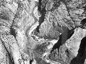
Entrenched river
Encyclopedia

River
A river is a natural watercourse, usually freshwater, flowing towards an ocean, a lake, a sea, or another river. In a few cases, a river simply flows into the ground or dries up completely before reaching another body of water. Small rivers may also be called by several other names, including...
that is confined to a canyon
Canyon
A canyon or gorge is a deep ravine between cliffs often carved from the landscape by a river. Rivers have a natural tendency to reach a baseline elevation, which is the same elevation as the body of water it will eventually drain into. This forms a canyon. Most canyons were formed by a process of...
or gorge, usually with a relatively narrow width and little or no flood plain, and often with meander
Meander
A meander in general is a bend in a sinuous watercourse. A meander is formed when the moving water in a stream erodes the outer banks and widens its valley. A stream of any volume may assume a meandering course, alternately eroding sediments from the outside of a bend and depositing them on the...
s worn into the landscape. Such rivers form when the base level
Base level
The base level of a river or stream is the lowest point to which it can flow, often referred to as the 'mouth' of the river. For large rivers, sea level is usually the base level, but a large river or lake is likewise the base level for tributary streams...
of erosion is rapidly lowered, so that the river begins downcutting
Downcutting
Downcutting, also called erosional downcutting or downward erosion or vertical erosion is a geological process that deepens the channel of a stream or valley by removing material from the stream's bed or the valley's floor. How fast downcutting occurs depends on the stream's base level, which is...
into its channel faster than it can change course (which rivers normally do on a constant basis). This may occur due to tectonic uplift
Tectonic uplift
Tectonic uplift is a geological process most often caused by plate tectonics which increases elevation. The opposite of uplift is subsidence, which results in a decrease in elevation. Uplift may be orogenic or isostatic.-Orogenic uplift:...
of the region, a lowering of the oceans, the collapse of a moraine-dammed lake downstream, or by capture of the river by another. Meanders established before the lowering of the base level of erosion may be preserved as the river channel deepens subsequently. Examples of entrenched meanders may be seen in the Snake River Canyon
Snake River Canyon (Idaho)
Snake River Canyon is a large canyon formed by the Snake River in the Magic Valley region of southern Idaho. It is well known as the site of an unsuccessful 1974 attempt by Evel Knievel to jump it in the Skycycle X-2....
in southern Idaho
Idaho
Idaho is a state in the Rocky Mountain area of the United States. The state's largest city and capital is Boise. Residents are called "Idahoans". Idaho was admitted to the Union on July 3, 1890, as the 43rd state....
, and in many canyons of the Colorado Plateau
Colorado Plateau
The Colorado Plateau, also called the Colorado Plateau Province, is a physiographic region of the Intermontane Plateaus, roughly centered on the Four Corners region of the southwestern United States. The province covers an area of 337,000 km2 within western Colorado, northwestern New Mexico,...
.


