Epping railway station, Sydney
Encyclopedia
Epping railway station is on the Northern Line
of the CityRail
network in Sydney
, Australia
. It serves the suburb of Epping
, a significant commercial
and residential area
. Epping is a significant interchange station
and is the western terminus of the Epping to Chatswood Line. Easy Access to all platforms is available via lifts.
opened on 17 September 1886, a single platform
known as Field of Mars was located on the western side of the line opposite Chester Street. The platform was renamed Carlingford on 5 April 1887.
The station was renamed Epping when it opened in its current location on 7 October 1899 as an island platform
. An additional island platform was added in 1928. The centre track was originally a terminating road, and was served by platforms on each side between both island platforms. This was intended as part of Dr Bradfield's proposed Epping to St Leonards line. A new booking office on the footbridge
was added in 1967 after the original wooden structure was destroyed by fire.
Upgrade works began in 2004 to prepare the station for the Epping to Chatswood railway line. Works included a new concourse
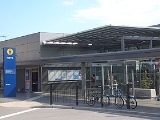
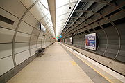
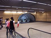
& pedestrian overpass, wider platforms, an underground transfer concourse and the addition of two underground platforms for the new line. The new aerial concourse was constructed to the north of the 1967 concourse, which was demolished. The above ground upgrades were completed on 14 April 2007, while the underground concourse and platforms were opened on 23 February 2009 in conjunction with the new line.
at Epping until its closure on 12 November 2006. The original miniature lever frame was replaced by an NX panel circa 1980. Control of the area was transferred to Strathfield signal box
, and then to the new Homebush Signal Box in October 2008.
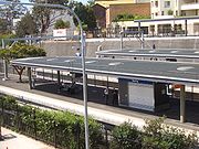
The station consists of three above ground platforms and two underground platforms. The above ground platforms are connected to the overhead concourse. The underground platforms are accessed from the above ground platforms via escalators through an underground transfer concourse and a lift for wheelchair access. Unusually for CityRail stations, Epping's above ground platforms are not aligned with each other. With the conversion of the centre terminating track to a bi-directional
main line in 1979, the platform face on the up (platform 1) side was fenced off. As part of the 2000s upgrading works, the fencing was switched to the opposite platform.
_trackplan.png)


 Epping Station does not have a Platform 4.
Services via Epping Road
Services to Parramatta
Other Services
Northern railway line, Sydney
The Northern Line is part of the metropolitan rail network in Sydney known as CityRail. It serves the northern suburbs of Sydney and the Lower North Shore, along with parts of the Inner West and the Hills District. The line utilises the Epping to Chatswood Line and parts of the Main Northern Line,...
of the CityRail
CityRail
CityRail is an operating brand of RailCorp, a corporation owned by the state government of New South Wales, Australia. It is responsible for providing commuter rail services, and some coach services, in and around Sydney, Newcastle and Wollongong, the three largest cities of New South Wales. It is...
network in Sydney
Sydney
Sydney is the most populous city in Australia and the state capital of New South Wales. Sydney is located on Australia's south-east coast of the Tasman Sea. As of June 2010, the greater metropolitan area had an approximate population of 4.6 million people...
, Australia
Australia
Australia , officially the Commonwealth of Australia, is a country in the Southern Hemisphere comprising the mainland of the Australian continent, the island of Tasmania, and numerous smaller islands in the Indian and Pacific Oceans. It is the world's sixth-largest country by total area...
. It serves the suburb of Epping
Epping, New South Wales
Epping is a suburb of Sydney, in the state of New South Wales, Australia. Epping is located 18 kilometres north-west of the Sydney central business district in the local government areas of the City of Ryde, the City of Parramatta and Hornsby Shire and is located in the Northern...
, a significant commercial
Commerce
While business refers to the value-creating activities of an organization for profit, commerce means the whole system of an economy that constitutes an environment for business. The system includes legal, economic, political, social, cultural, and technological systems that are in operation in any...
and residential area
Residential area
A residential area is a land use in which housing predominates, as opposed to industrial and commercial areas.Housing may vary significantly between, and through, residential areas. These include single family housing, multi-family residential, or mobile homes. Zoning for residential use may permit...
. Epping is a significant interchange station
Interchange station
An interchange station or a transfer station is a train station for more than one railway route in a public transport system, and allows passengers to change from one route to another. Transfer may occur within the same mode, or between rail modes, or to buses...
and is the western terminus of the Epping to Chatswood Line. Easy Access to all platforms is available via lifts.
History
When the Main Northern LineMain North railway line, New South Wales
The Main North Line is a major railway in New South Wales, Australia. It runs through the Central Coast, Hunter and the New England regions. The line was the original main line between Sydney and Brisbane, however this required a change of gauge at Wallangarra...
opened on 17 September 1886, a single platform
Railway platform
A railway platform is a section of pathway, alongside rail tracks at a train station, metro station or tram stop, at which passengers may board or alight from trains or trams. Almost all stations for rail transport have some form of platforms, with larger stations having multiple platforms...
known as Field of Mars was located on the western side of the line opposite Chester Street. The platform was renamed Carlingford on 5 April 1887.
The station was renamed Epping when it opened in its current location on 7 October 1899 as an island platform
Island platform
An island platform is a station layout arrangement where a single platform is positioned between two tracks within a railway station, tram stop or transitway interchange...
. An additional island platform was added in 1928. The centre track was originally a terminating road, and was served by platforms on each side between both island platforms. This was intended as part of Dr Bradfield's proposed Epping to St Leonards line. A new booking office on the footbridge
Footbridge
A footbridge or pedestrian bridge is a bridge designed for pedestrians and in some cases cyclists, animal traffic and horse riders, rather than vehicular traffic. Footbridges complement the landscape and can be used decoratively to visually link two distinct areas or to signal a transaction...
was added in 1967 after the original wooden structure was destroyed by fire.
Upgrade works began in 2004 to prepare the station for the Epping to Chatswood railway line. Works included a new concourse
Concourse
A concourse is a place where pathways or roads meet, such as in a hotel, a convention center, a railway station, an airport terminal, a hall, or other space.-Examples:Examples of concourses include:* Meeting halls* Universities* Railway stations...
& pedestrian overpass, wider platforms, an underground transfer concourse and the addition of two underground platforms for the new line. The new aerial concourse was constructed to the north of the 1967 concourse, which was demolished. The above ground upgrades were completed on 14 April 2007, while the underground concourse and platforms were opened on 23 February 2009 in conjunction with the new line.
Signal box
Epping signal box opened on 31 October 1928 and operated the interlockingInterlocking
In railway signalling, an interlocking is an arrangement of signal apparatus that prevents conflicting movements through an arrangement of tracks such as junctions or crossings. The signalling appliances and tracks are sometimes collectively referred to as an interlocking plant...
at Epping until its closure on 12 November 2006. The original miniature lever frame was replaced by an NX panel circa 1980. Control of the area was transferred to Strathfield signal box
Signal box
On a rail transport system, signalling control is the process by which control is exercised over train movements by way of railway signals and block systems to ensure that trains operate safely, over the correct route and to the proper timetable...
, and then to the new Homebush Signal Box in October 2008.
Station configuration
Epping station sits in the centre of the suburb's commercial district, between Langston Place and Beecroft Road. Access to the station is via an overhead concourse with ticketing facilities and ticket gates. The unpaid area of the concourse connects to a covered pedestrian footbridge over the busy Beecroft Road. As well as providing access to the station, this enables thoroughfare between the two sides of the railway line.The station consists of three above ground platforms and two underground platforms. The above ground platforms are connected to the overhead concourse. The underground platforms are accessed from the above ground platforms via escalators through an underground transfer concourse and a lift for wheelchair access. Unusually for CityRail stations, Epping's above ground platforms are not aligned with each other. With the conversion of the centre terminating track to a bi-directional
Bi-directional
Bi-directional may refer to:* Bi-directional text* Two-way communication* Bi-directional railway signalling* Controls at each end of a tram or railcar...
main line in 1979, the platform face on the up (platform 1) side was fenced off. As part of the 2000s upgrading works, the fencing was switched to the opposite platform.
Platforms and services
The station is served by eight trains per hour each way, with additional trains during weekday peak hours._trackplan.png)


Bus services
Epping station is a major interchange for bus services for the Northwest region of Sydney, due to its proximity to Epping Road (one of the major bus routes to the Sydney CBD). The new bus interchange at Cambridge Street commenced operations on 27 July 2007. Stops also exist on Beecroft Road, on the western side, for routes 541-549.Services via Epping Road
- metrobusMetrobus (Sydney)Metrobus is a high frequency, high capacity public transportation network in Sydney that links key employment and growth centres. Metrobuses run every 10 minutes during peak periods, 15 minutes during off-peak weekday periods, and 20 minutes on weekends, with the intention of making timetables...
M54 - Macquarie Park via Macquarie UniversityMacquarie UniversityMacquarie University is an Australian public teaching and research university located in Sydney, with its main campus situated in Macquarie Park. Founded in 1964 by the New South Wales Government, it was the third university to be established in the metropolitan area of Sydney... - 140 - ManlyManly, New South WalesManly is a suburb of northern Sydney, in the state of New South Wales, Australia. Manly is located 17 kilometres north-east of the Sydney central business district and is the administrative centre of the local government area of Manly Council, in the Northern Beaches region.-History:Manly was named...
via Macquarie CentreMacquarie CentreMacquarie Centre is a regional sized shopping centre located between Herring, Waterloo and Talevera Roads in the suburb of Macquarie Park in Sydney, New South Wales, Australia and opposite Macquarie University's main campus....
, Crows NestCrows Nest, New South WalesCrows Nest is a suburb on the lower North Shore of Sydney, New South Wales, Australia. Crows Nest is located 5 kilometres north of the Sydney central business district, in the local government area of North Sydney Council.-History:...
(weekdays Only) - 288 - SydneySydneySydney is the most populous city in Australia and the state capital of New South Wales. Sydney is located on Australia's south-east coast of the Tasman Sea. As of June 2010, the greater metropolitan area had an approximate population of 4.6 million people...
QVB via Macquarie UniversityMacquarie UniversityMacquarie University is an Australian public teaching and research university located in Sydney, with its main campus situated in Macquarie Park. Founded in 1964 by the New South Wales Government, it was the third university to be established in the metropolitan area of Sydney...
, Macquarie CentreMacquarie CentreMacquarie Centre is a regional sized shopping centre located between Herring, Waterloo and Talevera Roads in the suburb of Macquarie Park in Sydney, New South Wales, Australia and opposite Macquarie University's main campus....
, North RydeNorth Ryde, New South WalesNorth Ryde is a suburb of Sydney, in the state of New South Wales, Australia. North Ryde is located 15 kilometres north-west of the Sydney central business district, in the local government area of the City of Ryde...
, Lane Cove - 290 - SydneySydneySydney is the most populous city in Australia and the state capital of New South Wales. Sydney is located on Australia's south-east coast of the Tasman Sea. As of June 2010, the greater metropolitan area had an approximate population of 4.6 million people...
QVB via Macquarie UniversityMacquarie UniversityMacquarie University is an Australian public teaching and research university located in Sydney, with its main campus situated in Macquarie Park. Founded in 1964 by the New South Wales Government, it was the third university to be established in the metropolitan area of Sydney...
, Macquarie CentreMacquarie CentreMacquarie Centre is a regional sized shopping centre located between Herring, Waterloo and Talevera Roads in the suburb of Macquarie Park in Sydney, New South Wales, Australia and opposite Macquarie University's main campus....
, Lane Cove, St LeonardsSt Leonards, New South WalesSt Leonards is a suburb on the lower North Shore of Sydney, in the state of New South Wales, Australia. St Leonards is located 5 km north-west of the Sydney central business district and lies across the local government areas of Municipality of Lane Cove, North Sydney Council and the City of...
, Crows NestCrows Nest, New South WalesCrows Nest is a suburb on the lower North Shore of Sydney, New South Wales, Australia. Crows Nest is located 5 kilometres north of the Sydney central business district, in the local government area of North Sydney Council.-History:...
, North SydneyNorth Sydney, New South WalesNorth Sydney is a suburb and commercial district on the Lower North Shore of Sydney, in the state of New South Wales, Australia. North Sydney is located 3 kilometres north of the Sydney central business district and is the administrative centre for the local government area of North Sydney... - 294 - SydneySydneySydney is the most populous city in Australia and the state capital of New South Wales. Sydney is located on Australia's south-east coast of the Tasman Sea. As of June 2010, the greater metropolitan area had an approximate population of 4.6 million people...
QVB via Macquarie UniversityMacquarie UniversityMacquarie University is an Australian public teaching and research university located in Sydney, with its main campus situated in Macquarie Park. Founded in 1964 by the New South Wales Government, it was the third university to be established in the metropolitan area of Sydney...
, Macquarie CentreMacquarie CentreMacquarie Centre is a regional sized shopping centre located between Herring, Waterloo and Talevera Roads in the suburb of Macquarie Park in Sydney, New South Wales, Australia and opposite Macquarie University's main campus....
, Lane Cove - 295 - from North Epping, continues to Marsfield, Macquarie UniversityMacquarie UniversityMacquarie University is an Australian public teaching and research university located in Sydney, with its main campus situated in Macquarie Park. Founded in 1964 by the New South Wales Government, it was the third university to be established in the metropolitan area of Sydney...
, Macquarie CentreMacquarie CentreMacquarie Centre is a regional sized shopping centre located between Herring, Waterloo and Talevera Roads in the suburb of Macquarie Park in Sydney, New South Wales, Australia and opposite Macquarie University's main campus....
Services to Parramatta
- metrobusMetrobus (Sydney)Metrobus is a high frequency, high capacity public transportation network in Sydney that links key employment and growth centres. Metrobuses run every 10 minutes during peak periods, 15 minutes during off-peak weekday periods, and 20 minutes on weekends, with the intention of making timetables...
M54 - ParramattaParramatta, New South WalesParramatta is a suburb of Sydney, in the state of New South Wales, Australia. It is located in Greater Western Sydney west of the Sydney central business district on the banks of the Parramatta River. Parramatta is the administrative seat of the Local Government Area of the City of Parramatta...
via Carlingford Station - 546 - ParramattaParramatta, New South WalesParramatta is a suburb of Sydney, in the state of New South Wales, Australia. It is located in Greater Western Sydney west of the Sydney central business district on the banks of the Parramatta River. Parramatta is the administrative seat of the Local Government Area of the City of Parramatta...
via OatlandsOatlands, New South WalesOatlands is a suburb of Sydney, in the state of New South Wales, Australia. Oatlands is located 23 kilometres north-west of the Sydney central business district in the local government areas of the City of Parramatta and The Hills Shire...
, Westfield North RocksWestfield North RocksWestfield North Rocks is a shopping centre, located in North Rocks, a suburb of Sydney. The shopping centre is located 26 km from Sydney's central business district on North Rocks Road, which links to the Hills Motorway via Pennant Hills Road....
, Carlingford Station, Carlingford CourtCarlingford CourtCarlingford Court is a major shopping centre located in Carlingford, a north-western suburb of Sydney, New South Wales, Australia.Carlingford Court has been managed and fully owned by GPT since July 1996... - 549 - ParramattaParramatta, New South WalesParramatta is a suburb of Sydney, in the state of New South Wales, Australia. It is located in Greater Western Sydney west of the Sydney central business district on the banks of the Parramatta River. Parramatta is the administrative seat of the Local Government Area of the City of Parramatta...
via North ParramattaNorth Parramatta, New South WalesNorth Parramatta is a suburb of Sydney, in the state of New South Wales, Australia. North Parramatta is located 24 kilometres north-west of the Sydney central business district in the local government area of the City of Parramatta...
, Westfield North RocksWestfield North RocksWestfield North Rocks is a shopping centre, located in North Rocks, a suburb of Sydney. The shopping centre is located 26 km from Sydney's central business district on North Rocks Road, which links to the Hills Motorway via Pennant Hills Road....
Other Services
- 541 - EastwoodEastwood, New South WalesEastwood is a suburb of Sydney, in the state of New South Wales, Australia. Eastwood is located 17 kilometres north-west of the Sydney central business district in the local government areas of the City of Ryde and the City of Parramatta...
- 630 - from BlacktownBlacktown, New South WalesBlacktown is a suburb in the City of Blacktown, in Western Sydney, in the state of New South Wales, Australia. Blacktown is located 34 kilometres west of the Sydney central business district and is the administrative centre of the local government area of City of Blacktown.Blacktown is the largest...
via Baulkham Hills, continues to Macquarie UniversityMacquarie UniversityMacquarie University is an Australian public teaching and research university located in Sydney, with its main campus situated in Macquarie Park. Founded in 1964 by the New South Wales Government, it was the third university to be established in the metropolitan area of Sydney...
, Macquarie CentreMacquarie CentreMacquarie Centre is a regional sized shopping centre located between Herring, Waterloo and Talevera Roads in the suburb of Macquarie Park in Sydney, New South Wales, Australia and opposite Macquarie University's main campus.... - N80 - NightRideNightRideNightRide is a network of bus routes in operation between midnight and 5.00 am in Sydney, Australia. The eleven routes are run by private bus operators and allow for a nightly shutdown of the CityRail commuter rail network. Established by the New South Wales Ministry of Transport and monitored by...
Bus services to HornsbyHornsby- Places :* Hornsby, Cumbria, a place in Cumbria, Northern England* Hornsby, New South Wales, suburb of Sydney, Australia** Hornsby Shire, New South Wales, local government area of Sydney...
and Town HallSydney Town HallThe Sydney Town Hall is a landmark sandstone building located in the heart of Sydney. It stands opposite the Queen Victoria Building and alongside St Andrew's Cathedral...

