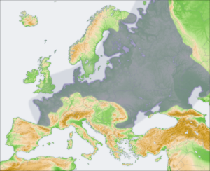
European Plain
Encyclopedia


Plain
In geography, a plain is land with relatively low relief, that is flat or gently rolling. Prairies and steppes are types of plains, and the archetype for a plain is often thought of as a grassland, but plains in their natural state may also be covered in shrublands, woodland and forest, or...
in Europe
Europe
Europe is, by convention, one of the world's seven continents. Comprising the westernmost peninsula of Eurasia, Europe is generally 'divided' from Asia to its east by the watershed divides of the Ural and Caucasus Mountains, the Ural River, the Caspian and Black Seas, and the waterways connecting...
. It is the largest mountain
Mountain
Image:Himalaya_annotated.jpg|thumb|right|The Himalayan mountain range with Mount Everestrect 58 14 160 49 Chomo Lonzorect 200 28 335 52 Makalurect 378 24 566 45 Mount Everestrect 188 581 920 656 Tibetan Plateaurect 250 406 340 427 Rong River...
-free landform
Landform
A landform or physical feature in the earth sciences and geology sub-fields, comprises a geomorphological unit, and is largely defined by its surface form and location in the landscape, as part of the terrain, and as such, is typically an element of topography...
in Europe, although a number of highlands
Highland (geography)
The term highland or upland is used to denote any mountainous region or elevated mountainous plateau. Generally speaking, the term upland tends to be used for ranges of hills, typically up to 500-600m, and highland for ranges of low mountains.The Scottish Highlands refers to the mountainous...
are identified within. It stretches from the Pyrenees Mountains and the Atlantic Ocean
Atlantic Ocean
The Atlantic Ocean is the second-largest of the world's oceanic divisions. With a total area of about , it covers approximately 20% of the Earth's surface and about 26% of its water surface area...
in the west to the Ural Mountains
Ural Mountains
The Ural Mountains , or simply the Urals, are a mountain range that runs approximately from north to south through western Russia, from the coast of the Arctic Ocean to the Ural River and northwestern Kazakhstan. Their eastern side is usually considered the natural boundary between Europe and Asia...
in the east.
It consists of the North European Plain and the East European Plain
East European Plain
The East European Plain is a plain comprising a series of river basins in Eastern Europe. Together with the Northern European Plain it constitutes the European Plain. It is the largest mountain-free part of the European landscape.The plain spans approximately and averages about in elevation...
. The subdivision is a historical one, rather than geomorphological: the East European Plain
East European Plain
The East European Plain is a plain comprising a series of river basins in Eastern Europe. Together with the Northern European Plain it constitutes the European Plain. It is the largest mountain-free part of the European landscape.The plain spans approximately and averages about in elevation...
was part of the European Plain within the Russian Empire
Russian Empire
The Russian Empire was a state that existed from 1721 until the Russian Revolution of 1917. It was the successor to the Tsardom of Russia and the predecessor of the Soviet Union...
and therefore was formerly known as the Russian Plain.
In Western Europe, the plain is relatively narrow (mostly within 200 miles) in the northern part of Europe, but it broadens significantly toward its eastern part in Western Russia.
The plains are cut by many important rivers like the Loire
Loire (river)
The Loire is the longest river in France. With a length of , it drains an area of , which represents more than a fifth of France's land area. It is the 170th longest river in the world...
, Rhine and Vistula
Vistula
The Vistula is the longest and the most important river in Poland, at 1,047 km in length. The watershed area of the Vistula is , of which lies within Poland ....
in the west; the Northern Dvina
Northern Dvina
The Northern Dvina is a river in Northern Russia flowing through the Vologda Oblast and Arkhangelsk Oblast into the Dvina Bay of the White Sea. Along with the Pechora River to the east, it drains most of Northwest Russia into the Arctic Ocean...
and Daugava flowing northwards in Eastern Europe and Russia and the Volga, the Don
Don River (Russia)
The Don River is one of the major rivers of Russia. It rises in the town of Novomoskovsk 60 kilometres southeast from Tula, southeast of Moscow, and flows for a distance of about 1,950 kilometres to the Sea of Azov....
and the Dnieper flowing southwards of the European Russia
European Russia
European Russia refers to the western areas of Russia that lie within Europe, comprising roughly 3,960,000 square kilometres , larger in area than India, and spanning across 40% of Europe. Its eastern border is defined by the Ural Mountains and in the south it is defined by the border with...
.

