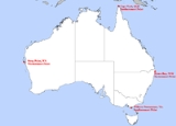
Extreme points of Australia
Overview
- Northernmost Point – Cape YorkCape York PeninsulaCape York Peninsula is a large remote peninsula located in Far North Queensland at the tip of the state of Queensland, Australia, the largest unspoilt wilderness in northern Australia and one of the last remaining wilderness areas on Earth...
, QueenslandQueenslandQueensland is a state of Australia, occupying the north-eastern section of the mainland continent. It is bordered by the Northern Territory, South Australia and New South Wales to the west, south-west and south respectively. To the east, Queensland is bordered by the Coral Sea and Pacific Ocean...
(10°41' S) - Southernmost Point – South PointSouth Point (Wilsons Promontory)South Point is the southernmost point of the Australian mainland located on the northern side of Bass Strait. It is also the southernmost point of the mainland of the Wilsons Promontory-Peninsula. South Point is located at . South Point is also part of the Wilsons Promontory National Park in...
, Wilsons PromontoryWilsons PromontoryWilsons Promontory is a peninsula that forms the southernmost part of the Australian mainland and is located at . South Point at is the southernmost tip of Wilsons Promontory and hence of mainland Australia...
, VictoriaVictoria (Australia)Victoria is the second most populous state in Australia. Geographically the smallest mainland state, Victoria is bordered by New South Wales, South Australia, and Tasmania on Boundary Islet to the north, west and south respectively....
(39°08' S) - South-westernmost Point - Cape LeeuwinCape LeeuwinCape Leeuwin is the most south-westerly mainland point of the Australian Continent, in the state of Western Australia.A few small islands and rocks, the St Alouarn Islands, extend further to the south. The nearest settlement, north of the cape, is Augusta. South-east of Cape Leeuwin, the coast...
, Western AustraliaWestern AustraliaWestern Australia is a state of Australia, occupying the entire western third of the Australian continent. It is bounded by the Indian Ocean to the north and west, the Great Australian Bight and Indian Ocean to the south, the Northern Territory to the north-east and South Australia to the south-east...
(34° 22′S. 115° 8′E)
- Westernmost Point – Steep PointSteep Point, Western AustraliaSteep Point is the westernmost point of the Australian mainland, located at . It is located within the Shark Bay World Heritage site in the Gascoyne region of Western Australia....
, Western AustraliaWestern AustraliaWestern Australia is a state of Australia, occupying the entire western third of the Australian continent. It is bounded by the Indian Ocean to the north and west, the Great Australian Bight and Indian Ocean to the south, the Northern Territory to the north-east and South Australia to the south-east...
(113°09' E) - Easternmost Point – Cape ByronCape ByronCape Byron is the easternmost point of the mainland of Australia. It is located about northeast of the town of Byron Bay and projects into the Pacific Ocean...
, New South WalesNew South WalesNew South Wales is a state of :Australia, located in the east of the country. It is bordered by Queensland, Victoria and South Australia to the north, south and west respectively. To the east, the state is bordered by the Tasman Sea, which forms part of the Pacific Ocean. New South Wales...
(153°38' E) - Lowest Point – Lake EyreLake EyreLake Eyre is the lowest point in Australia, at approximately below sea level, and, on the rare occasions that it fills, it is the largest lake in Australia and 18th largest in the world...
: -15 m - Highest Point – Mount KosciuszkoMount KosciuszkoMount Kosciuszko is a mountain located in the Snowy Mountains in Kosciuszko National Park. With a height of 2,228 metres above sea level, it is the highest mountain in Australia...
: 2228 metres (7,310 ft) - Planimetric Center of Gravity - Lambert Centre (25º 36' 36.4" S 134º 21' 17.33" E)
- Northernmost Point – Bramble CayBramble CayBramble Cay, also called Naizab Kaur, Massaramcoer or Baramaki, and located at the northeastern edge of the Torres Strait Islands of Queensland and at the same time at the northern end of the Great Barrier Reef, is the northernmost point of land of Australia...
, northeast Torres Strait IslandsTorres Strait IslandsThe Torres Strait Islands are a group of at least 274 small islands which lie in Torres Strait, the waterway separating far northern continental Australia's Cape York Peninsula and the island of New Guinea but Torres Strait Island known and Recognize as Nyumaria.The islands are mostly part of...
, QueenslandQueenslandQueensland is a state of Australia, occupying the north-eastern section of the mainland continent. It is bordered by the Northern Territory, South Australia and New South Wales to the west, south-west and south respectively. To the east, Queensland is bordered by the Coral Sea and Pacific Ocean...
(9°8'23"S, 143°52'54"E) - Southernmost Point – Bishop and Clerk IsletsBishop and Clerk IsletsThe Bishop and Clerk Islets lie approximately to the south of Macquarie Island. They are in area. The Bishop and Clerk Islets mark the southernmost point of Australia . These islets are mostly barren rock less than high and are geologically similar to Macquarie Island.Macquarie Shags have...
, 34 km south of Macquarie IslandMacquarie IslandMacquarie Island lies in the southwest corner of the Pacific Ocean, about half-way between New Zealand and Antarctica, at 54°30S, 158°57E. Politically, it has formed part of the Australian state of Tasmania since 1900 and became a Tasmanian State Reserve in 1978. In 1997 it became a world heritage...
, TasmaniaTasmaniaTasmania is an Australian island and state. It is south of the continent, separated by Bass Strait. The state includes the island of Tasmania—the 26th largest island in the world—and the surrounding islands. The state has a population of 507,626 , of whom almost half reside in the greater Hobart...
.

