

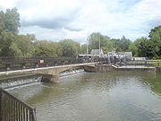
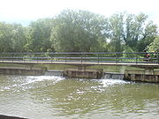
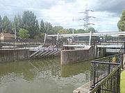
Feildes Weir
Encyclopedia
Weir
A weir is a small overflow dam used to alter the flow characteristics of a river or stream. In most cases weirs take the form of a barrier across the river that causes water to pool behind the structure , but allows water to flow over the top...
on the River Lea located near Hoddesdon
Hoddesdon
Hoddesdon is a town in the English county of Hertfordshire, situated in the Lea Valley. The town grew up as a coaching stop on the route between Cambridge and London. It is located southeast of Hertford, north of Waltham Cross and southwest of Bishop's Stortford. At its height during the 18th...
, Hertfordshire
Hertfordshire
Hertfordshire is a ceremonial and non-metropolitan county in the East region of England. The county town is Hertford.The county is one of the Home Counties and lies inland, bordered by Greater London , Buckinghamshire , Bedfordshire , Cambridgeshire and...
at the confluence of the River Lea and River Stort
River Stort
River Stort is a tributary of the River Lea which it joins at Hoddesdon, Hertfordshire at Feildes Weir-Overview:River Stort takes its name from Bishop's Stortford, a town through which it flows. It was given the name in the 16th century....
. The weir marks the start of the Lower Lee. A channel of the man-made River Lee Flood Relief Channel
River Lee Flood Relief Channel
The River Lee Flood Relief Channel is located in the Lea Valley and flows between Ware, Hertfordshire and Stratford, east London. Work started on the channel in 1947 following major flooding and was fully operational by 1976...
is incorporated into the weir.
History
The weir has had a complex history of changes to channel control and bypassing over the years. Control was originally exercised by a barrage of gates and sluices.In 1976 a 29 metre wide thin-plate weir was installed, with three vertical-lift sluices controlling a parallel flood relief channel. Flows average about 4.4 m3/s discharge over the weir; higher flows enter the flood channel .
Road
- From Hoddesdon via A10 road, A1170 road to Dinant Link Road to Rattys Lane.
- From NazeingNazeingNazeing is a parish of 3,952 lying about four miles north of Waltham Abbey, England and bounded on the west by the River Lea. Most of it is still rural, but during the past 40 years there has been a considerable development of market gardening, light industry, holiday fishing, and boating...
via Dobbs WeirDobbs WeirDobbs Weir is a both a weir near and an area of Hoddesdon, Hertfordshire in England on the River Lea. It is well known for angling, outdoor beauty and watersports. It is overlooked by the Fish and Eels pub.-Angling:...
Road.