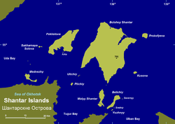
Feklistova Island
Encyclopedia

Shantar Islands
The Shantar Islands are a group of fifteen islands that lie in Uda Bay, in the southwestern zone of the Sea of Okhotsk. These islands are located close to the shores of the Siberian mainland...
in Sea of Okhotsk
Sea of Okhotsk
The Sea of Okhotsk is a marginal sea of the western Pacific Ocean, lying between the Kamchatka Peninsula on the east, the Kuril Islands on the southeast, the island of Hokkaidō to the far south, the island of Sakhalin along the west, and a long stretch of eastern Siberian coast along the west and...
. With an area of 372 km², it is the second largest in the archipelago.
Feklistova lies about 20 km to the west of Bolshoy Shantar Island
Bolshoy Shantar Island
Bolshoy Shantar is an island in the Sea of Okhotsk, Russia. It is the main island of the Shantar Islands. Its area is 1766 km².It is about 72 km in length and 49 km in width. It has a large brackish lake in its northern end which is connected to the sea through a narrow passage....
, the main island in the group. Feklistov Island is covered with taiga forest and has a 3 km long lake in its northern shore separated from the sea by a landspit.
Administratively this island belongs to the Khabarovsk Krai
Khabarovsk Krai
Khabarovsk Krai is a federal subject of Russia , located in the Russian Far East. It lies mostly in the basin of the lower Amur River, but also occupies a vast mountainous area along the coastline of the Sea of Okhotsk, an arm of the Pacific Ocean. The administrative center of the krai is the...
of the Russian Federation.
This island is part of the "Kondyor-Feklistov metallogenic
Metallogeny
Metallogeny is the study of the genesis and regional to global distribution of mineral deposits, with emphasis on their relationship in space and time to regional petrologic and tectonic features of the Earth's crust.-References:...
belt" (KD) owing to the presence of placer
Placer deposit
In geology, a placer deposit or placer is an accumulation of valuable minerals formed by gravity separation during sedimentary processes. The name is from the Spanish word placer, meaning "alluvial sand". Placer mining is an important source of gold, and was the main technique used in the early...
s which include minerals like "blacksand platinum
Platinum
Platinum is a chemical element with the chemical symbol Pt and an atomic number of 78. Its name is derived from the Spanish term platina del Pinto, which is literally translated into "little silver of the Pinto River." It is a dense, malleable, ductile, precious, gray-white transition metal...
".
The "Kondyor-Feklistov metallogenic belt" is one of the major metallogenic belts of Northeast Asia. It is assumed that it formed by an oblique subduction of the oceanic crust of the Mongol-Okhotsk paleoocean under the southern margin of the Siberian continent.

