Forbes County, New South Wales
Encyclopedia
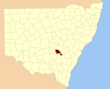
Forbes County is one of the 141 Cadastral divisions of New South Wales
.
Forbes County was named in honour of Chief Justice Sir Francis Forbes
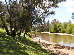
(1784-1841). It is located south of the Lachlan River
near Forbes
, down to Grenfell
. It includes the area along the Lachlan east to Cowra
and the Boorowa River
, and also south to Koorawatha

Cadastral divisions of New South Wales
Lands administrative divisions of New South Wales refers to the 141 counties within the Australian state of New South Wales, which are further subdivided into 7,459 parishes. There are also three Land Divisions, around 100 Land Districts, and several other types of districts as well as land boards...
.
Forbes County was named in honour of Chief Justice Sir Francis Forbes
Francis Forbes
Sir Francis Forbes was a Chief Justice of the Supreme Court of Newfoundland, and the first Chief Justice of the Supreme Court of New South Wales.-Early life:...
(1784-1841). It is located south of the Lachlan River
Lachlan River
- Course :The river rises in the central highland of New South Wales, part of the Great Dividing Range, 13 km east of Gunning. Its major headwaters, the Carcoar River, the Belubula River and the Abercrombie River converge near the town of Cowra. Minor tributaries include the Morongla Creek...
near Forbes
Forbes, New South Wales
-Notable residents:*Carolyn Simpson - Judge of the Supreme Court of New South Wales; Member of the first all-female bench to sit in an Australian court*NSW Deputy Premier Carmel Tebbutt was born and raised in Forbes....
, down to Grenfell
Grenfell, New South Wales
Grenfell is a country town in the Central West of New South Wales, Australia, in Weddin Shire. It is 370 kilometres west of Sydney and five hours' drive from the city. It is close to Forbes, Cowra and Young. At the 2006 census, Grenfell had a population of 1,994.-History:Prior to European...
. It includes the area along the Lachlan east to Cowra
Cowra, New South Wales
Cowra is a town in the Central West region of New South Wales, Australia in the Cowra Shire. It is located on the Mid-Western Highway, 317 kilometres west of Sydney on the banks of the Lachlan River at an altitude of 310 metres above sea level. At the 2006 census Cowra had a population of 8,430...
and the Boorowa River
Boorowa River
-References:...
, and also south to Koorawatha
Koorawatha, New South Wales
Koorawatha is a town in the Central West region of New South Wales, Australia, on the Olympic Highway between Cowra and Young. It was once a large and thriving centre of activity but now has only a hotel and a cafe. It is, nevertheless, a very fine old-style hotel, though not a fancy one, with a...

Parishes within this county
A full list of parishes found within this county; their current LGA and mapping coordinates to the approximate centre of each location is as follows:| Parish | LGA | Coordinates |
|---|---|---|
| Bandon | Forbes Shire | 33°31′54"S 148°15′04"E |
| Bang Bang | Cowra Shire | 34°01′54"S 148°38′04"E |
| Binda Binda, New South Wales Binda is a village in the Southern Tablelands region of New South Wales, Australia in Upper Lachlan Shire. In 2006, Binda had a population of 131 people.It is about 17 km north-north-west of Crookwell in the county of Georgiana... |
Weddin Shire Weddin Shire Weddin Shire is a Local Government Area in New South Wales, Australia. Its only significant town is Grenfell.... |
33°38′54"S 148°23′04"E |
| Birangan | Weddin Shire Weddin Shire Weddin Shire is a Local Government Area in New South Wales, Australia. Its only significant town is Grenfell.... |
33°42′54"S 148°07′04"E |
| Bogolong | Weddin Shire Weddin Shire Weddin Shire is a Local Government Area in New South Wales, Australia. Its only significant town is Grenfell.... |
33°48′54"S 148°05′04"E |
| Boyd | Forbes Shire | 33°54′54"S 147°36′04"E |
| Braulin | Forbes Shire | 33°30′54"S 148°01′04"E |
| Broula | Cowra Shire | 33°50′54"S 148°33′04"E |
| Bundaburrah | Forbes Shire | 33°30′54"S 147°53′04"E |
| Conimbla | Cowra Shire | 33°46′54"S 148°31′04"E |
| Cudgelong | Cowra Shire | 33°54′54"S 148°46′04"E |
| Cumbijowa | Forbes Shire | 33°25′54"S 148°08′04"E |
| Currowong | Forbes Shire | 33°40′54"S 147°50′04"E |
| Erasa | Forbes Shire | 33°15′54"S 148°12′04"E |
| Eualdrie | Weddin Shire Weddin Shire Weddin Shire is a Local Government Area in New South Wales, Australia. Its only significant town is Grenfell.... |
33°53′54"S 148°03′04"E |
| Gooloogong Gooloogong, New South Wales Gooloogong is a village located in central New South Wales, Australia. At the 2006 census, Gooloogong and the surrounding area had a population of 852.... |
Cowra Shire | 33°39′54"S 148°31′04"E |
| Goonigal | Forbes Shire | 33°37′54"S 148°17′04"E |
| Jemalong | Forbes Shire | 33°26′54"S 147°48′04"E |
| Kangarooby | Weddin Shire Weddin Shire Weddin Shire is a Local Government Area in New South Wales, Australia. Its only significant town is Grenfell.... |
33°42′54"S 148°20′04"E |
| Maudry | Forbes Shire | 33°41′54"S 148°03′04"E |
| Melyra | Weddin Shire Weddin Shire Weddin Shire is a Local Government Area in New South Wales, Australia. Its only significant town is Grenfell.... |
33°48′54"S 148°11′04"E |
| Merriganowry | Cowra Shire | 33°44′54"S 148°32′04"E |
| Morongla | Cowra Shire | 33°53′54"S 148°39′04"E |
| Mulyan | Cowra Shire | 33°48′54"S 148°35′04"E |
| Mulyandry | Forbes Shire | 33°31′54"S 148°07′04"E |
| Nanima | Forbes Shire | 33°31′54"S 148°20′04"E |
| Neila | Cowra Shire | 34°01′54"S 148°43′04"E |
| Ooma | Forbes Shire | 33°38′54"S 148°09′04"E |
| Tallabung | Forbes Shire | 33°33′54"S 147°49′04"E |
| Thurungle | Forbes Shire | 33°35′54"S 148°02′04"E |
| Waayourigong | Forbes Shire | 33°25′54"S 147°54′04"E |
| Wallah Wallah | Weddin Shire Weddin Shire Weddin Shire is a Local Government Area in New South Wales, Australia. Its only significant town is Grenfell.... |
33°44′54"S 148°15′04"E |
| Warraderry | Weddin Shire Weddin Shire Weddin Shire is a Local Government Area in New South Wales, Australia. Its only significant town is Grenfell.... |
33°41′54"S 148°13′04"E |
| Warrangong | Cowra Shire | 33°59′54"S 148°30′04"E |
| Warrumba | Cowra Shire | 33°48′54"S 148°22′04"E |
| Wattamondara | Cowra Shire | 33°54′54"S 148°37′04"E |
| Wheoga | Weddin Shire Weddin Shire Weddin Shire is a Local Government Area in New South Wales, Australia. Its only significant town is Grenfell.... |
33°45′54"S 147°56′04"E |
| Wongajong | Forbes Shire | 33°25′54"S 148°02′04"E |

