Forbidden Plateau
Encyclopedia


Plateau
In geology and earth science, a plateau , also called a high plain or tableland, is an area of highland, usually consisting of relatively flat terrain. A highly eroded plateau is called a dissected plateau...
in the east of the Vancouver Island
Vancouver Island
Vancouver Island is a large island in British Columbia, Canada. It is one of several North American locations named after George Vancouver, the British Royal Navy officer who explored the Pacific Northwest coast of North America between 1791 and 1794...
Ranges
Vancouver Island Ranges
The Vancouver Island Ranges, formerly called the Vancouver Island Mountains, is a mountain range extending along the length of Vancouver Island which has an area of 31,788 km² . The Vancouver Island Ranges comprise the central and largest part of the island...
in British Columbia
British Columbia
British Columbia is the westernmost of Canada's provinces and is known for its natural beauty, as reflected in its Latin motto, Splendor sine occasu . Its name was chosen by Queen Victoria in 1858...
, located northwest of Comox Lake roughly between Mount Albert Edward to the southwest and Mount Washington (site of the Mount Washington Alpine Resort
Mount Washington Alpine Resort
Mount Washington Alpine Resort is an alpine skiing ski resort located on Mount Washington on the eastern edge of the Vancouver Island Ranges in British Columbia, Canada...
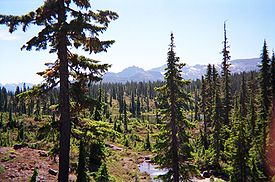
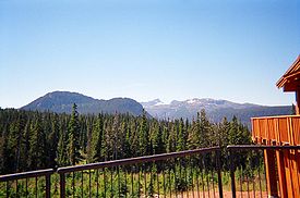
) to the northeast. The gently sloping sub-alpine terrain is broken by small, rugged hills and pitted with small lakes. Much of it is contained within Strathcona Provincial Park
Strathcona Provincial Park
Strathcona Provincial Park is the oldest provincial park in British Columbia, Canada, and the largest on Vancouver Island. Founded in 1911, the park was named for Donald Alexander Smith, 1st Baron Strathcona and Mount Royal, a wealthy philanthropist and railroad pioneer. It lies within the...
, and a network of trails facilitate hiking
Hiking
Hiking is an outdoor activity which consists of walking in natural environments, often in mountainous or other scenic terrain. People often hike on hiking trails. It is such a popular activity that there are numerous hiking organizations worldwide. The health benefits of different types of hiking...
, cross country skiing, and access to Mount Albert Edward. A sub-alpine meadow on Mount Beecher in the southwest corner of the plateau is the only site in Canada of the Olympic onion (Allium crenulatum).
In 1946, it was the epicentre of an earthquake
Earthquake
An earthquake is the result of a sudden release of energy in the Earth's crust that creates seismic waves. The seismicity, seismism or seismic activity of an area refers to the frequency, type and size of earthquakes experienced over a period of time...
that registered 7.3 on the Richter scale, the strongest ever recorded on land in Canada. See 1946 Vancouver Island earthquake
1946 Vancouver Island earthquake
The 1946 Vancouver Island earthquake was a 7.3 magnitude earthquake that struck Vancouver Island, on the Coast of British Columbia, Canada, at 10:15 a.m. on Sunday, June 23, 1946. The main shock epicenter occurred in the Forbidden Plateau area northwest of Courtenay...
.
The Legend
When the Comox peopleComox people
The Komox people, usually known in English as the Comox people and also spelled K'omoks, are an indigenous group of Coast Salishan-speaking people in Comox, British Columbia and in the Toba Inlet and Malaspina Peninsula areas of the British Columbia mainland across Georgia Strait...
faced raids from other coastal tribes, they took their women and children to the plateau for safekeeping. Once, during a raid by the Cowichan, the women and children vanished without a trace. When a member of the tribe went looking for the women and children within the Forbidden Plateau, he found red lichen covering the snow and nearby rocks and assumed the lichen to be blood from the family members. Since then, the plateau has become taboo for it was believed that it was inhabited by evil spirits who had consumed those they had sent. http://www.folklore.bc.ca/Locallegends.htm http://seattletimes.nwsource.com/html/sports/2002428510_nootkaside09.html http://books.google.com/books?vid=ISBN0774810556&id=LMzgxL7WhzAC&pg=PA164&lpg=PA164&dq=%22forbidden+plateau%22+legend&sig=xotONp7NZwbDC8J133FCPbrVpNg

