Fort Beversreede
Encyclopedia


Schuylkill River
The Schuylkill River is a river in Pennsylvania. It is a designated Pennsylvania Scenic River.The river is about long. Its watershed of about lies entirely within the state of Pennsylvania. The source of its eastern branch is in the Appalachian Mountains at Tuscarora Springs, near Tamaqua in...
and the Delaware River
Delaware River
The Delaware River is a major river on the Atlantic coast of the United States.A Dutch expedition led by Henry Hudson in 1609 first mapped the river. The river was christened the South River in the New Netherland colony that followed, in contrast to the North River, as the Hudson River was then...
. It was an outpost of the colony of New Netherland
New Netherland
New Netherland, or Nieuw-Nederland in Dutch, was the 17th-century colonial province of the Republic of the Seven United Netherlands on the East Coast of North America. The claimed territories were the lands from the Delmarva Peninsula to extreme southwestern Cape Cod...
, which was centered around its capital, New Amsterdam
New Amsterdam
New Amsterdam was a 17th-century Dutch colonial settlement that served as the capital of New Netherland. It later became New York City....
(Manhattan), on the North River (Hudson River).
Location
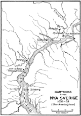
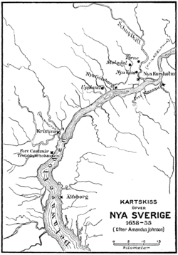
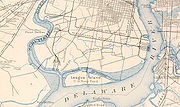
There is a dispute about the exact location of the fort. A 1655 Swedish map shows it on the west bank of the Schuylkill RiverSchuylkill River
The Schuylkill River is a river in Pennsylvania. It is a designated Pennsylvania Scenic River.The river is about long. Its watershed of about lies entirely within the state of Pennsylvania. The source of its eastern branch is in the Appalachian Mountains at Tuscarora Springs, near Tamaqua in...
, on Providence Island (now part of the mainland), just south of Minquas (also known as Eagle's Nest or Mingo) Creek. Scharf & Westcott put it on the east bank of the Schuylkill River
Schuylkill River
The Schuylkill River is a river in Pennsylvania. It is a designated Pennsylvania Scenic River.The river is about long. Its watershed of about lies entirely within the state of Pennsylvania. The source of its eastern branch is in the Appalachian Mountains at Tuscarora Springs, near Tamaqua in...
, opposite Minquas Creek. A 1770s map of Philadelphia's naval defenses shows a fort on the island, but it is unidentified.
Directly adjacent to (or opposite) the fort was the terminus of the Great Minquas Path
Great Minquas Path
Great Minquas Path was a 17th-century trade route that ran through southeastern Pennsylvania from the Susquehanna River, near Conestoga, to the Schuylkill River, opposite Philadelphia. The 80-mile east-west trail was the primary route for fur trading with the Minquas people...
, an 80-mile (130 km) trail from the Susquehanna River
Susquehanna River
The Susquehanna River is a river located in the northeastern United States. At long, it is the longest river on the American east coast that drains into the Atlantic Ocean, and with its watershed it is the 16th largest river in the United States, and the longest river in the continental United...
to the Schuylkill River
Schuylkill River
The Schuylkill River is a river in Pennsylvania. It is a designated Pennsylvania Scenic River.The river is about long. Its watershed of about lies entirely within the state of Pennsylvania. The source of its eastern branch is in the Appalachian Mountains at Tuscarora Springs, near Tamaqua in...
. This was the primary trade route for furs from the Susquehannock
Susquehannock
The Susquehannock people were Iroquoian-speaking Native Americans who lived in areas adjacent to the Susquehanna River and its tributaries from the southern part of what is now New York, through Pennsylvania, to the mouth of the Susquehanna in Maryland at the north end of the Chesapeake Bay...
people, and the Dutch named the trail "Beversreede" or "Beaver Road."
Swedes
Though never recognized by the DutchDutch people
The Dutch people are an ethnic group native to the Netherlands. They share a common culture and speak the Dutch language. Dutch people and their descendants are found in migrant communities worldwide, notably in Suriname, Chile, Brazil, Canada, Australia, South Africa, New Zealand, and the United...
, the Delaware Valley
Delaware Valley
The Delaware Valley is a term used to refer to the valley where the Delaware River flows, along with the surrounding communities. This includes the metropolitan area centered on the city of Philadelphia. Such educational institutions as Delaware Valley Regional High School in Alexandria Township...
region was effectively under control of the Swedish colony of New Sweden
New Sweden
New Sweden was a Swedish colony along the Delaware River on the Mid-Atlantic coast of North America from 1638 to 1655. Fort Christina, now in Wilmington, Delaware, was the first settlement. New Sweden included parts of the present-day American states of Delaware, New Jersey, and Pennsylvania....
, which was first settled in 1638 at Fort Christina
Fort Christina
Fort Christina was the first Swedish settlement in North America and the principal settlement of the New Sweden colony...
(now Wilmington, Delaware
Wilmington, Delaware
Wilmington is the largest city in the state of Delaware, United States, and is located at the confluence of the Christina River and Brandywine Creek, near where the Christina flows into the Delaware River. It is the county seat of New Castle County and one of the major cities in the Delaware Valley...
). Though the Swedes' colony included Dutch residents, the only official Dutch presence in the area was across the Delaware River
Delaware River
The Delaware River is a major river on the Atlantic coast of the United States.A Dutch expedition led by Henry Hudson in 1609 first mapped the river. The river was christened the South River in the New Netherland colony that followed, in contrast to the North River, as the Hudson River was then...
at Fort Nassau
Fort Nassau (South River)
Fort Nassau was a factorij in the colonial province of New Netherland from 1623-1651.The name Fort Nassau was used by the Dutch in the 17th century for several fortifications, mostly trading stations, named for the House of Orange-Nassau....
, at the mouth of Big Timber Creek
Big Timber Creek
Big Timber Creek is a stream in southwestern New Jersey, United States, and is also known by the name 'Tetamekanchz Kyl' by the Lenape tribes. It drains a watershed of . A tributary of the Delaware River, it enters the Delaware between the boroughs of Brooklawn and Westville, just south Gloucester...
(south of today's Gloucester City, New Jersey
Gloucester City, New Jersey
Gloucester City is a city in Camden County, New Jersey, United States. As of the United States 2010 Census, the city population was 11,456.-Geography:Gloucester City is located at ....
).
The Swedes had a competing claim for land at the mouth of the Schuylkill River, and they often vandalized Fort Beversreede. In 1648, they built a stockaded 30-by-20-foot blockhouse
Blockhouse
In military science, a blockhouse is a small, isolated fort in the form of a single building. It serves as a defensive strong point against any enemy that does not possess siege equipment or, in modern times, artillery...
directly in front of it. Their Fort Nya Korsholm was meant to intimidate the Dutch residents and intercept trade. In 1651, the Dutch abandoned Fort Beversreede and dismantled and relocated Fort Nassau to the Christina River
Christina River
The Christina River is a tributary of the Delaware River, approximately 35 miles long, in northern Delaware in the United States, also flowing through small areas of southeastern Pennsylvania and northeastern Maryland. Near its mouth the river flows past downtown Wilmington, Delaware,...
, downstream from the Swedes' Fort Christina
Fort Christina
Fort Christina was the first Swedish settlement in North America and the principal settlement of the New Sweden colony...
. The Dutch consolidated their forces at the rebuilt fort, renamed Fort Casimir
Fort Casimir
Fort Casimir was a Dutch settlement in 17th century colonial province of New Netherland. It was located on a no-longer existing barrier island at the end of Chestnut Street in what is now New Castle, Delaware...
. It was not until 1655 that control of the area was regained by the Dutch in a military expedition led by Director-General of New Netherland
Director-General of New Netherland
This is a list of Directors, appointed by the Dutch West India Company, of the 17th century Dutch province of New Netherland in North America...
Petrus Stuyvesant, establishing a regional capital at New Amstel.
Site
There is no remnant of either Fort Beversreede or Fort Nya Korsholm. Nearby Mud Island became the site of Fort MifflinFort Mifflin
Fort Mifflin, originally called Fort Island Battery and also known as Mud Island Fort, was commissioned in 1771 and sits on Mud Island on the Delaware River below Philadelphia, Pennsylvania near Philadelphia International Airport...
in 1771. Widening of the Schuylkill's channel, subsequent land reclamation
Land reclamation
Land reclamation, usually known as reclamation, is the process to create new land from sea or riverbeds. The land reclaimed is known as reclamation ground or landfill.- Habitation :...
, as well as other transportation and industrial infrastructure have dramatically changed the area. But the site of the forts (whether on the east or west bank of the Schuylkill) is probably south of the mouth of Mingo Creek and north of the George C. Platt Bridge
George C. Platt Bridge
The George C. Platt Memorial Bridge is a through truss bridge that carries PA 291 over the Schuylkill River in Philadelphia, Pennsylvania. It was opened to traffic in 1951, replacing a swing bridge to the south which carried Penrose Ferry Road across the river...
.
See also
- Pidgen Delaware
- Fort WilhelmusFort WilhelmusFort Wilhelmus was a factorij in the 17th century colonial province of New Netherland, located on what had been named Verhulsten Island on the Zuyd Rivier, today's Delaware River....
- Peach Tree WarPeach Tree WarThe Peach Tree War, also known as the "Peach War," is the name given to a large scale attack on the New Netherland colony of Pavonia, across from New Amsterdam, and surrounding settlements along the North River by the Susquehannock Nation and allied Native Americans on September 15,...
- Fortifications of New NetherlandFortifications of New NetherlandNew Netherland, or Nieuw-Nederland in Dutch, was the seventeenth century colonial province of the Republic of the Seven United Netherlands on northeastern coast of North America. The claimed territory were the lands from the Delmarva Peninsula to southern Cape Cod. Settled areas are now part of...
- New Netherland settlementsNew Netherland settlementsNew Netherland, or Nieuw-Nederland in Dutch, was the 17th century colonial province of the Republic of the Seven United Netherlands on northeastern coast of North America. The claimed territory were the lands from the Delmarva Peninsula to southern Cape Cod. Settled areas are now part of...
External links
- http://www.rootsweb.ancestry.com/~nycoloni/nswamap.htmlAmandus Johnson detailed map of Delaware ValleyDelaware ValleyThe Delaware Valley is a term used to refer to the valley where the Delaware River flows, along with the surrounding communities. This includes the metropolitan area centered on the city of Philadelphia. Such educational institutions as Delaware Valley Regional High School in Alexandria Township...
1638-1655] - Current map of Province Island

