Fowler Ice Rise
Encyclopedia

Ice rise
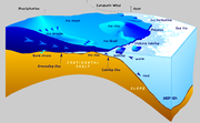
An ice rise is a clearly defined elevation of the otherwise totally flat ice shelf, typically dome-shaped and rising 100 to 200 meters above the surrounding ice shelf. An ice rise forms where the ice shelf touches the rocky seabed because of an elevation in the seabed that remains below sea level...
between Evans Ice Stream
Evans Ice Stream
Evans Ice Stream is a large ice stream draining from Ellsworth Land, between Cape Zumberge and Fowler Ice Rise, into the western part of Ronne Ice Shelf. The feature was recorded on February 5, 1974 in Landsat imagery...
and Carlson Inlet
Carlson Inlet
Carlson Inlet is an ice-filled inlet, long and wide, lying between Fletcher Ice Rise and Fowler Ice Rise in the southwest part of the Ronne Ice Shelf. It was named by the Advisory Committee on Antarctic Names for Lieutenant Ronald F. Carlson, U.S...
, in the southwest part of Ronne Ice Shelf. The feature appears to be completely ice covered except for Haag Nunataks
Haag Nunataks
Haag Nunataks are a group of three low elevations aligned nearly north-south. The dominant central nunatak and the southern elevation have definite rock exposures; the minor northern elevation may be entirely snow covered...
, which protrude above the surface in the northwest portion. It was mapped by the United States Geological Survey
United States Geological Survey
The United States Geological Survey is a scientific agency of the United States government. The scientists of the USGS study the landscape of the United States, its natural resources, and the natural hazards that threaten it. The organization has four major science disciplines, concerning biology,...
(USGS) Landsat imagery taken 1973-74, and named by the Advisory Committee on Antarctic Names
Advisory Committee on Antarctic Names
The Advisory Committee on Antarctic Names is an advisory committee of the United States Board on Geographic Names responsible for recommending names for features in Antarctica...
(US-ACAN) for Capt. Alfred N. Fowler, USN (Ret.), Commander, U.S. Naval Support Force, Antarctica, 1972-74.
An ice rise is a clearly defined elevation of the otherwise totally flat ice shelf
Ice shelf
An ice shelf is a thick, floating platform of ice that forms where a glacier or ice sheet flows down to a coastline and onto the ocean surface. Ice shelves are only found in Antarctica, Greenland and Canada. The boundary between the floating ice shelf and the grounded ice that feeds it is called...
, typically dome-shaped and rising 100 to 200 meters above the surrounding ice shelf. An ice rise forms where the ice shelf touches the rocky seabed
Seabed
The seabed is the bottom of the ocean.- Ocean structure :Most of the oceans have a common structure, created by common physical phenomena, mainly from tectonic movement, and sediment from various sources...
because of an elevation in the seabed that remains below sea level. (In contrast, an elevation in the seabed that extends above sea level is defined as an island
Island
An island or isle is any piece of sub-continental land that is surrounded by water. Very small islands such as emergent land features on atolls can be called islets, cays or keys. An island in a river or lake may be called an eyot , or holm...
). The ice shelf flows over the seabed elevation, completely covering it with ice, thereby forming an ice rise. The resulting tension forms crevasse
Crevasse
A crevasse is a deep crack in an ice sheet rhys glacier . Crevasses form as a result of the movement and resulting stress associated with the sheer stress generated when two semi-rigid pieces above a plastic substrate have different rates of movement...
s around the ice rise.
An island within and totally covered by the ice shelf, may appear the exactly the same as an ice rise. Elaborate measurements may be required to distinguish between these two geographic features.
Although ice rises are typically located within the ice shelf area, they can partially face the open sea. Ice rises are found only on the ice shelves of Antarctica, mostly on Ronne Ice Shelf.

