
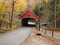
Franconia Notch State Park
Encyclopedia

White Mountains (New Hampshire)
The White Mountains are a mountain range covering about a quarter of the state of New Hampshire and a small portion of western Maine in the United States. Part of the Appalachian Mountains, they are considered the most rugged mountains in New England...
in northern New Hampshire
New Hampshire
New Hampshire is a state in the New England region of the northeastern United States of America. The state was named after the southern English county of Hampshire. It is bordered by Massachusetts to the south, Vermont to the west, Maine and the Atlantic Ocean to the east, and the Canadian...
and straddles 8 miles (12.9 km) of Interstate 93
Interstate 93
Interstate 93 is an Interstate Highway in the New England section of the United States. Its southern terminus is in Canton, Massachusetts, in the Boston metropolitan area, at Interstate 95; its northern terminus is near St. Johnsbury, Vermont, at Interstate 91...
as it passes through Franconia Notch
Franconia Notch
Franconia Notch is a major mountain pass through the White Mountains of New Hampshire. Dominated by Cannon Mountain, it lies principally within Franconia Notch State Park and is traversed by the Franconia Notch Parkway Franconia Notch (el. 1950 ft. / 590 m.) is a major mountain pass through...
, a mountain pass
Mountain pass
A mountain pass is a route through a mountain range or over a ridge. If following the lowest possible route, a pass is locally the highest point on that route...
between the Kinsman Range
Mountain range
A mountain range is a single, large mass consisting of a succession of mountains or narrowly spaced mountain ridges, with or without peaks, closely related in position, direction, formation, and age; a component part of a mountain system or of a mountain chain...
and Franconia Range
Franconia Range
The Franconia Range is a mountain range located in the White Mountains of the U.S. state of New Hampshire. It is the second-highest range of peaks in the White Mountains....
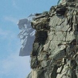
. Attractions in the state park include the Flume Gorge and visitor center, the Old Man of the Mountain
Old Man of the Mountain
The Old Man of the Mountain, also known as the Great Stone Face or the Profile, was a series of five granite cliff ledges on Cannon Mountain in the White Mountains of New Hampshire, USA that, when viewed from the north, appeared to be the jagged profile of a face. The rock formation was above...
historical site, fishing in Echo Lake
Echo Lake (Franconia Notch)
Echo Lake is a water body located in Franconia Notch in the White Mountains of New Hampshire, at the foot of Cannon Mountain. The lake is in the Connecticut River watershed, near the height of land in Franconia Notch; water from the lake's outlet flows north via Lafayette Brook to the Gale River,...
and Profile Lake
Profile Lake
Profile Lake is a water body located in Franconia Notch in the White Mountains of New Hampshire, at the foot of Cannon Mountain. The lake was given its name due to its location directly beneath the Old Man of the Mountain, a famous rock formation which collapsed in 2003...
, and miles of hiking, biking and ski trails. The northern part of the park, including Cannon Mountain and Echo and Profile lakes, is in the town of Franconia
Franconia, New Hampshire
Franconia is a town in Grafton County, New Hampshire, United States. The population was 1,104 at the 2010 census. Set in the White Mountains, Franconia is home to the northern half of Franconia Notch State Park. Parts of the White Mountain National Forest are in the eastern and southern portions...
, and the southern part, including Lonesome Lake and the Flume, is in Lincoln
Lincoln, New Hampshire
Lincoln is a town in Grafton County, New Hampshire, United States. It is the second-largest town by area in New Hampshire. The population was 1,662 at the 2010 census. The town is home to the New Hampshire Highland Games and to a portion of Franconia Notch State Park. Set in the White Mountains,...
.
The park is home to Cannon Mountain, a state-owned ski resort
Cannon Mountain Ski Area
Cannon Mountain Ski Area, located on Cannon Mountain in the White Mountains of New Hampshire, is a state-owned resort that offers nine lifts servicing of skiing . Cannon Mountain has the most vertical of any ski area in New Hampshire, and the seventh largest in New England.It also has the only...
started in the 1930s. The mountain is named for a rock formation in the shape of a cannon found on the summit, but the "Old Man of the Mountain" formation was by far the more famous; it collapsed in May of 2003. Cannon is also famous for being one of the most challenging hills in New England. It boasts an aerial tram, which runs year-round, ferrying sightseers to the summit in the summer time and skiers in the winter. At the base of the tramway is the New England Ski Museum, with exhibits on the history of alpine skiing in New England and America.
On the west side of the notch, halfway up the side of Cannon Mountain, is Lonesome Lake
Lonesome Lake (New Hampshire)
Lonesome Lake is a water body located in Franconia Notch in the White Mountains of New Hampshire, south of Cannon Mountain. The lake is reachable by hiking trails from the Franconia Notch Parkway and features an Appalachian Mountain Club hut on its southwest shore.The lake lies in the Merrimack...
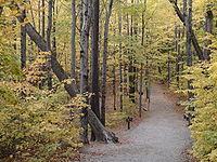
, an easy day hike up the Lonesome Lake Trail from the state park's Lafayette Place campground. The Lonesome Lake Hut, one of numerous well-kept huts throughout the White Mountains that are maintained by the Appalachian Mountain Club
Appalachian Mountain Club
The Appalachian Mountain Club is one of the United States' oldest outdoor groups. Created in 1876 to explore and preserve the White Mountains in New Hampshire, it has expanded throughout the northeastern U.S., with 12 chapters stretching from Maine to Washington, D.C...
, is found at the southwest end of the lake, near its outlet. Huts offer meals and lodging (reservations are recommended).
Opposite Cannon Mountain, on the east side of the notch, are the Eagle Cliffs, so named for the eagles that sometimes roost there. The Greenleaf Trail, a hiking trail, winds around the south side of the cliff and up to Greenleaf Hut, another AMC hut. East of Greenleaf Hut and outside of the state park is the 5249 feet (1,599.9 m) summit of Mount Lafayette and the Franconia Ridge Trail (also the Appalachian Trail
Appalachian Trail
The Appalachian National Scenic Trail, generally known as the Appalachian Trail or simply the AT, is a marked hiking trail in the eastern United States extending between Springer Mountain in Georgia and Mount Katahdin in Maine. It is approximately long...
). The Appalachian Trail continues north to Mount Washington
Mount Washington (New Hampshire)
Mount Washington is the highest peak in the Northeastern United States at , famous for dangerously erratic weather. For 76 years, a weather observatory on the summit held the record for the highest wind gust directly measured at the Earth's surface, , on the afternoon of April 12, 1934...
and eventually to Mount Katahdin
Mount Katahdin
Mount Katahdin is the highest mountain in Maine at . Named Katahdin by the Penobscot Indians, the term means "The Greatest Mountain". Katahdin is the centerpiece of Baxter State Park: a steep, tall mountain formed from underground magma. The flora and fauna on the mountain are typical of those...
in Maine.
Beneath a waterfall
Waterfall
A waterfall is a place where flowing water rapidly drops in elevation as it flows over a steep region or a cliff.-Formation:Waterfalls are commonly formed when a river is young. At these times the channel is often narrow and deep. When the river courses over resistant bedrock, erosion happens...
in the Pemigewasset River
Pemigewasset River
The Pemigewasset River , known locally as "The Pemi", is a river in the state of New Hampshire, the United States. It is in length and drains approximately...
is a granite
Granite
Granite is a common and widely occurring type of intrusive, felsic, igneous rock. Granite usually has a medium- to coarse-grained texture. Occasionally some individual crystals are larger than the groundmass, in which case the texture is known as porphyritic. A granitic rock with a porphyritic...
pothole about 20 feet (6 m) across known simply as "the Basin". It was scrubbed out by stones dragged (and eventually deposited) by the retreating North American ice sheet
Laurentide ice sheet
The Laurentide Ice Sheet was a massive sheet of ice that covered hundreds of thousands of square miles, including most of Canada and a large portion of the northern United States, multiple times during Quaternary glacial epochs. It last covered most of northern North America between c. 95,000 and...
, and since made smooth by 15 millennia of rapidly whirling pebbles and grit. Below the Basin is "Old Man's Foot", a distinctively shaped rock formation
Rock formation
This is a list of rock formations that include isolated, scenic, or spectacular surface rock outcrops. These formations are usually the result of weathering and erosion sculpting the existing rock...
, also the natural result of Pemigewasset's erosive energy.