Frontera, Santa Cruz de Tenerife
Encyclopedia
La Frontera is the westernmost municipality in El Hierro
, Santa Cruz de Tenerife
and the Canary Islands
, Spain
. It is situated on the western coast of El Hierro
. Until 2007, Frontera was one of the two municipalities in population that was larger than the island capital. Since 2007, the Southern part of the territory of Frontera has formed the new municipality of El Pinar
. Frontera is linked with the highway that encircles the whole island. The nearest small airport is around the area. The port is located downhill from the municipal seat.
Farmlands dominate the valley areas as well as the coastline, forests dominate the central parts part as well as grasslands and bushes in the highlands, a volcanic cone is located to the east.


s.
El Hierro
El Hierro, nicknamed Isla del Meridiano , is the smallest and farthest south and west of the Canary Islands , in the Atlantic Ocean off the coast of Africa, with a population of 10,162 .- Name :The name El Hierro, although phonetically identical to the Spanish word for 'iron', is generally thought...
, Santa Cruz de Tenerife
Santa Cruz de Tenerife (province)
Province of Santa Cruz de Tenerife also Province of Santa Cruz is a province of Spain, consisting of the western part of the autonomous community of the Canary Islands. It consists of about half of the Atlantic archipelago, including the islands of Tenerife, La Gomera, El Hierro, and La Palma, and...
and the Canary Islands
Canary Islands
The Canary Islands , also known as the Canaries , is a Spanish archipelago located just off the northwest coast of mainland Africa, 100 km west of the border between Morocco and the Western Sahara. The Canaries are a Spanish autonomous community and an outermost region of the European Union...
, Spain
Spain
Spain , officially the Kingdom of Spain languages]] under the European Charter for Regional or Minority Languages. In each of these, Spain's official name is as follows:;;;;;;), is a country and member state of the European Union located in southwestern Europe on the Iberian Peninsula...
. It is situated on the western coast of El Hierro
El Hierro
El Hierro, nicknamed Isla del Meridiano , is the smallest and farthest south and west of the Canary Islands , in the Atlantic Ocean off the coast of Africa, with a population of 10,162 .- Name :The name El Hierro, although phonetically identical to the Spanish word for 'iron', is generally thought...
. Until 2007, Frontera was one of the two municipalities in population that was larger than the island capital. Since 2007, the Southern part of the territory of Frontera has formed the new municipality of El Pinar
El Pinar
El Pinar is a Spanish municipality on the island of El Hierro. It was created in 2007.- References :...
. Frontera is linked with the highway that encircles the whole island. The nearest small airport is around the area. The port is located downhill from the municipal seat.
Farmlands dominate the valley areas as well as the coastline, forests dominate the central parts part as well as grasslands and bushes in the highlands, a volcanic cone is located to the east.
Sites of interest
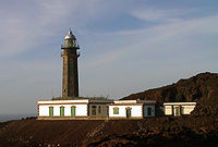
- Punta de la Orchilla - a lighthouse situated near the municipality. The lighthouse was first constructed to represent the old meridian. It used to mark the meridian line or the 0 degree-line at the lighthouse which was put by the FrenchFranceThe French Republic , The French Republic , The French Republic , (commonly known as France , is a unitary semi-presidential republic in Western Europe with several overseas territories and islands located on other continents and in the Indian, Pacific, and Atlantic oceans. Metropolitan France...
in 1634. Many 16th and 17th century maps had the meridian facing at Punta de la Orchilla until 1885 when the meridianMeridian (geography)A meridian is an imaginary line on the Earth's surface from the North Pole to the South Pole that connects all locations along it with a given longitude. The position of a point along the meridian is given by its latitude. Each meridian is perpendicular to all circles of latitude...
since that time moved east to GreenwichGreenwichGreenwich is a district of south London, England, located in the London Borough of Greenwich.Greenwich is best known for its maritime history and for giving its name to the Greenwich Meridian and Greenwich Mean Time...
during the conference in Washington D.C.. Before the meridian change, El Hierro was known as Isla del Meridiano (Meridian Island).
Historical population


| Year | Population | Change | Density |
|---|---|---|---|
| 1991 | 3,612 | - | - |
| 1996 | 4,409 | - | - |
| 2001 | 4,455 | - | 27/km² |
| 2002 | 5,359 | - | - |
| 2003 | 5,435 | - | 32.93/km² |
| 2004 | 5,231 | - | 31.65/km² |
Other
Frontera has a few schools, a few lyceums, a gymnasium, churches, a small beach, a small port, a post office and a few squares plazaPlaza
Plaza is a Spanish word related to "field" which describes an open urban public space, such as a city square. All through Spanish America, the plaza mayor of each center of administration held three closely related institutions: the cathedral, the cabildo or administrative center, which might be...
s.
External links
- Map and aerial photos
- Street map: Street map from Mapquest, MapPoint or Google
- Satellite images: Google
- Basic Information: (Spanish, English, German
| North: Atlantic Ocean Atlantic Ocean The Atlantic Ocean is the second-largest of the world's oceanic divisions. With a total area of about , it covers approximately 20% of the Earth's surface and about 26% of its water surface area... |
||
| West: Atlantic Ocean | Frontera | East: Valverde Valverde, Santa Cruz de Tenerife Valverde is a municipality in the Canary Islands in the province of Santa Cruz de Tenerife. It is located on the north-east part of El Hierro . The town of the same name serves as the island's official capital... |
| South: Atlantic Ocean |

