Gaberoun
Encyclopedia

Oasis
In geography, an oasis or cienega is an isolated area of vegetation in a desert, typically surrounding a spring or similar water source...
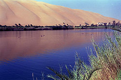
with a large lake located in the Wadi Al Hayaa District and Sabha District in the Fezzan
Fezzan
Fezzan is a south western region of modern Libya. It is largely desert but broken by mountains, uplands, and dry river valleys in the north, where oases enable ancient towns and villages to survive deep in the otherwise inhospitable Sahara.-Name:...
region of the Libyan Sahara Desert, in southwestern Libya
Libya
Libya is an African country in the Maghreb region of North Africa bordered by the Mediterranean Sea to the north, Egypt to the east, Sudan to the southeast, Chad and Niger to the south, and Algeria and Tunisia to the west....
.
A rudimentary tourist camp is located on the northeastern shore, including an open patio, sleeping huts, and a souvenir shop (attended by a Tuareg in full costume) in the winter. The lake is very salty; swimming can be pleasant despite the salt water crustacean
Crustacean
Crustaceans form a very large group of arthropods, usually treated as a subphylum, which includes such familiar animals as crabs, lobsters, crayfish, shrimp, krill and barnacles. The 50,000 described species range in size from Stygotantulus stocki at , to the Japanese spider crab with a leg span...
s. Mosquito
Mosquito
Mosquitoes are members of a family of nematocerid flies: the Culicidae . The word Mosquito is from the Spanish and Portuguese for little fly...
es are abundant, especially in the summer. October to May is considered the best time to visit as the climate is milder.
History
A small tribe inhabited the oasis; the ruins of their settlement are scattered between the palms at the north-western shore of the lake. It is said that one of their sources of subsistence were the worm-like crustaceanCrustacean
Crustaceans form a very large group of arthropods, usually treated as a subphylum, which includes such familiar animals as crabs, lobsters, crayfish, shrimp, krill and barnacles. The 50,000 described species range in size from Stygotantulus stocki at , to the Japanese spider crab with a leg span...
s they fished from the salty lake. They were moved in the 1980s to a new location outside the sand dunes, in the Wadi Bashir, south of the erg
Erg (landform)
An erg is a broad, flat area of desert covered with wind-swept sand with little or no vegetative cover. The term takes its name from the Arabic word ʿarq , meaning "dune field"...
, a settlement of concrete apartments built specifically for the resettlement of this tribe.
The old Bedouin
Bedouin
The Bedouin are a part of a predominantly desert-dwelling Arab ethnic group traditionally divided into tribes or clans, known in Arabic as ..-Etymology:...
settlement by the western shore of the lake has been abandoned, and now lies in ruins.
Access
The oasis is accessible from the Sabha-UbariUbari
Ubari is an oasis town and the capital of the Wadi al Hayaa District, in the Fezzan region of southwestern Libya. It is in the Libyan section of the Sahara Desert...
road (150km west of Sabha and north in the sand dunes at the settlement of Qasr Larocu), by a 36 km 4WD ride through the dune
Dune
In physical geography, a dune is a hill of sand built by wind. Dunes occur in different forms and sizes, formed by interaction with the wind. Most kinds of dunes are longer on the windward side where the sand is pushed up the dune and have a shorter "slip face" in the lee of the wind...
s of the Ubari
Ubari
Ubari is an oasis town and the capital of the Wadi al Hayaa District, in the Fezzan region of southwestern Libya. It is in the Libyan section of the Sahara Desert...
sand sea (also called Ramlat al Dauada).
Nearby attractions
Other nearby attractions are the El Mandara oasis (26.68972°N 13.31260°E), the Un Almaa oasis (26.70973°N 13.33208°E), Mafo Lake in the same sand erg (Ramlat al Dauada) and the museum in GermaGerma
Germa, known in ancient times as Garama, is an archaeological site in Libya and was the capital of the Garamantes.The Garamantes were a Berber people living in the Fezzan in the northeastern Sahara, originating from the Sahara's Tibesti region. Garamantian power climaxed during the 2nd and the 3rd...
.
External links
- Gaberoun, El Mandara and Un Almaa oasis seen in GoogleLocal
- German Travel Network LTI Tours - tours including visit of the Gaberoun oasis
- Libya photo album - with photos of the Gaberoun oasis

