
Gaithersburg Latitude Observatory
Encyclopedia
The Gaithersburg Latitude Observatory, in Gaithersburg, Maryland
is one of the system of six International Latitude Observatories
and (as of 2007) the only National Historic Landmark
in Gaithersburg, Maryland. The building is in the National Register of Historic Places
. The GLO was constructed by Edwin Smith, chief of the Instrument Division of the U.S. Coast and Geodetic Survey.
The Gaithersburg Latitude Observatory was one of six observatories — and one of the four original observatories built by 1899 — tracking the degree of "wobble"
occurring on the earth’s north-south axis and resultant variation of latitude. The Observatory — along with observatories in Cincinnati, Ohio; Ukiah, California; Mizusawa
, Japan; Charjui in Russian Turkestan; and Carloforte, Sardina, Italy — performed in concert to carry out a coordinated program of star observation designed to investigate and calculate the degree of earth “wobble” or latitude variation.
On the grounds of the Gaithersburg Latitude Observatory stands a plaque that reads:
A second portion of the observatory was constructed to house the Photographic Zenith Tube. The observers used the Photographic Zenith Tube to capture picture data using the Zenith telescope as a guide of alignment and star track. Unfortunately, time has not been very kind to this addition of the Gaithersburg Latitude Observatory as it no longer stands at the site.
. During it's operation twelve groups of stars were studied in the program, each group containing six pairs of stars. Each night, the station observed two of the star groups along a preset schedule and later compared the data against the measurements taken by the five sister stations. The station operated on this schedule until 1915, when it was temporarily closed as a result of economy measures. Operations resumed in 1932 and continued until 1982 when advances in computer technology and satellite observations rendered it obsolete, although data collected by the observatory over the years still has use to scientists, and has been applied to studies of polar motion, the physical properties of the Earth, climatology and satellite tracking and navigation.
.
foundation. Each gable features a decorative wood five-pointed star. A metal ventilator is mounted over each half-section's roof, topped with similar metal star. A system of metal-capped wood rails allows the building to be pulled apart in the middle using ropes and pulleys. The halves operate independently. The structure is double-walled, with an inner frame of 4×4s sheathed with tongue-and-groove boards, separated by 9 inches (22.9 cm) from the outer, louvered wall, also framed with 4×4s.
On the interior, a double floor surrounds a pyramidal concrete pier that supported the observing instruments. A 1½ story brick caretaker's house, built in 1947, is located 70 feet (21.3 m) to the south; it is excluded from the landmark designation.
The site was extensively surveyed and documented to support its mission. The Meridian Mark Pier, about 200 feet (61 m) to the south, was used to align the zenith telescope. Five Coast and Geodetic Survey
monuments are on the property. The RM-1 monument has been used by NOAA
for testing associated with the Global Positioning Satellite system.
Gaithersburg, Maryland
Gaithersburg is a city in Montgomery County, Maryland, United States. The city had a population of 59,933 at the 2010 census, making it the fourth largest incorporated city in the state, behind Baltimore, Frederick, and Rockville...
is one of the system of six International Latitude Observatories
International Latitude Observatory
The International Latitude Observatories were a system of six observatories located near the parallel of 39° 08' north latitude. They were used to measure the variation in latitude that occurs as a result of the "wobble" of the Earth on its polar axis.The original six observatories were located...
and (as of 2007) the only National Historic Landmark
National Historic Landmark
A National Historic Landmark is a building, site, structure, object, or district, that is officially recognized by the United States government for its historical significance...
in Gaithersburg, Maryland. The building is in the National Register of Historic Places
National Register of Historic Places
The National Register of Historic Places is the United States government's official list of districts, sites, buildings, structures, and objects deemed worthy of preservation...
. The GLO was constructed by Edwin Smith, chief of the Instrument Division of the U.S. Coast and Geodetic Survey.
The Gaithersburg Latitude Observatory was one of six observatories — and one of the four original observatories built by 1899 — tracking the degree of "wobble"
Chandler wobble
The Chandler wobble is a small motion in the Earth's axis of rotation relative to the Earth's surface, which was discovered by American astronomer Seth Carlo Chandler in 1891. It amounts to on the Earth's surface and has a period of 433 days...
occurring on the earth’s north-south axis and resultant variation of latitude. The Observatory — along with observatories in Cincinnati, Ohio; Ukiah, California; Mizusawa
Mizusawa, Iwate
Mizusawa was a city located in Iwate Prefecture, Japan.As of 2003, the city had an estimated population of 60,979 and a population density of 629.17 persons per km². The total area was 96.92 km².The city was founded on April 1, 1954....
, Japan; Charjui in Russian Turkestan; and Carloforte, Sardina, Italy — performed in concert to carry out a coordinated program of star observation designed to investigate and calculate the degree of earth “wobble” or latitude variation.
On the grounds of the Gaithersburg Latitude Observatory stands a plaque that reads:
- “This small framed structure played a key role in the scientific investigation of the Earth’s rotation. In 1898, the International Geodetic Association established a network of observatories to measure the wobble of the planet on its axis by plotting the locations of specific stars. This hilltop in Gaithersburg was chosen together with sites in California, Italy, Japan, and the Soviet Union. All five lay along the same latitude (39° 8’ N). The American Stations were supervised by the U.S. Coast and Geodetic Survey. The observatory’s roof was designed to part in the middle on two sets of tracks to expose the reflecting telescope inside to the night sky. Its slatted exterior walls stabilize the inside air to limit the effects of the temperatures on the accuracy of the telescope. The building’s white paint minimizes heat retention that creates air turbulence around the telescope at night, distorting the stars. Knowledge gained from the observations recorded here nightly until 1982 assisted scientists in the study of the Earth’s geophysical make-up and aided spacecraft orbiting the planer and navigating the universe.”
A second portion of the observatory was constructed to house the Photographic Zenith Tube. The observers used the Photographic Zenith Tube to capture picture data using the Zenith telescope as a guide of alignment and star track. Unfortunately, time has not been very kind to this addition of the Gaithersburg Latitude Observatory as it no longer stands at the site.
History
The Gaithersburg observatory was established as part of the International Polar Motion Service in 1899. The Gaithersburg observatory was built by Edwin Smith, chief of the Instrument Division of the U.S. Coast and Geodetic Survey, who had conducted similar measurements as a volunteer in 1891-92 from his home in Rockville, MarylandRockville, Maryland
Rockville is the county seat of Montgomery County, Maryland, United States. It is a major incorporated city in the central part of Montgomery County and forms part of the Baltimore-Washington Metropolitan Area. The 2010 U.S...
. During it's operation twelve groups of stars were studied in the program, each group containing six pairs of stars. Each night, the station observed two of the star groups along a preset schedule and later compared the data against the measurements taken by the five sister stations. The station operated on this schedule until 1915, when it was temporarily closed as a result of economy measures. Operations resumed in 1932 and continued until 1982 when advances in computer technology and satellite observations rendered it obsolete, although data collected by the observatory over the years still has use to scientists, and has been applied to studies of polar motion, the physical properties of the Earth, climatology and satellite tracking and navigation.
.
Description
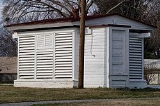
The building measures 13 feet (4 m) square with a small gable-roofed louvered entrance porch on the west side. There is a small shed-roofed addition on the east side. The structure rests on a mortar and fieldstoneFieldstone
Fieldstone is a building construction material. Strictly speaking, it is stone collected from the surface of fields where it occurs naturally...
foundation. Each gable features a decorative wood five-pointed star. A metal ventilator is mounted over each half-section's roof, topped with similar metal star. A system of metal-capped wood rails allows the building to be pulled apart in the middle using ropes and pulleys. The halves operate independently. The structure is double-walled, with an inner frame of 4×4s sheathed with tongue-and-groove boards, separated by 9 inches (22.9 cm) from the outer, louvered wall, also framed with 4×4s.
On the interior, a double floor surrounds a pyramidal concrete pier that supported the observing instruments. A 1½ story brick caretaker's house, built in 1947, is located 70 feet (21.3 m) to the south; it is excluded from the landmark designation.
The site was extensively surveyed and documented to support its mission. The Meridian Mark Pier, about 200 feet (61 m) to the south, was used to align the zenith telescope. Five Coast and Geodetic Survey
U.S. National Geodetic Survey
National Geodetic Survey, formerly called the U.S. Coast and Geodetic Survey , is a United States federal agency that defines and manages a national coordinate system, providing the foundation for transportation and communication; mapping and charting; and a large number of applications of science...
monuments are on the property. The RM-1 monument has been used by NOAA
National Oceanic and Atmospheric Administration
The National Oceanic and Atmospheric Administration , pronounced , like "noah", is a scientific agency within the United States Department of Commerce focused on the conditions of the oceans and the atmosphere...
for testing associated with the Global Positioning Satellite system.
External links
- 1989 Drawings of the Gaithersburg Latitude Observatory at the Library of CongressLibrary of CongressThe Library of Congress is the research library of the United States Congress, de facto national library of the United States, and the oldest federal cultural institution in the United States. Located in three buildings in Washington, D.C., it is the largest library in the world by shelf space and...
External links
- Gaithersburg Latitude Observatory, Montgomery County, including photo in 1991, at Maryland Historical Trust