Garabogazköl
Encyclopedia


Turkmenistan
Turkmenistan , formerly also known as Turkmenia is one of the Turkic states in Central Asia. Until 1991, it was a constituent republic of the Soviet Union, the Turkmen Soviet Socialist Republic . Turkmenistan is one of the six independent Turkic states...
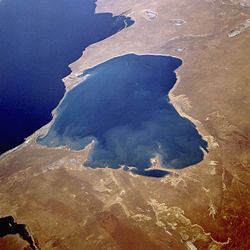
. It forms a lagoon
Lagoon
A lagoon is a body of shallow sea water or brackish water separated from the sea by some form of barrier. The EU's habitat directive defines lagoons as "expanses of shallow coastal salt water, of varying salinity or water volume, wholly or partially separated from the sea by sand banks or shingle,...
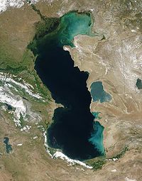
of the Caspian Sea
Caspian Sea
The Caspian Sea is the largest enclosed body of water on Earth by area, variously classed as the world's largest lake or a full-fledged sea. The sea has a surface area of and a volume of...
with a surface area
Surface area
Surface area is the measure of how much exposed area a solid object has, expressed in square units. Mathematical description of the surface area is considerably more involved than the definition of arc length of a curve. For polyhedra the surface area is the sum of the areas of its faces...
of about 18000 square kilometre. It is separated from the Caspian, which lies immediately to the west, by a narrow, rocky ridge
Ridge
A ridge is a geological feature consisting of a chain of mountains or hills that form a continuous elevated crest for some distance. Ridges are usually termed hills or mountains as well, depending on size. There are several main types of ridges:...
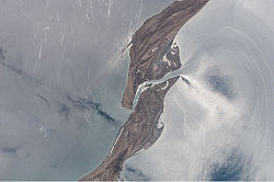
having a very narrow opening in the rock through which the Caspian waters flow, cascading down into Garabogazköl (whence the name of the bay—"Mighty Strait Lake" in the Turkmen language—comes). The water
Water
Water is a chemical substance with the chemical formula H2O. A water molecule contains one oxygen and two hydrogen atoms connected by covalent bonds. Water is a liquid at ambient conditions, but it often co-exists on Earth with its solid state, ice, and gaseous state . Water also exists in a...
volume
Volume
Volume is the quantity of three-dimensional space enclosed by some closed boundary, for example, the space that a substance or shape occupies or contains....
of the bay
Bay
A bay is an area of water mostly surrounded by land. Bays generally have calmer waters than the surrounding sea, due to the surrounding land blocking some waves and often reducing winds. Bays also exist as an inlet in a lake or pond. A large bay may be called a gulf, a sea, a sound, or a bight...
fluctuates seasonally with the Caspian Sea; at times it becomes a large bay of the Caspian Sea, while at other times its water level
Water level
Water level or gage height or stage is the elevation of the free surface of a stream, lake or reservoir relative to a specified datum ....
drops drastically.
The city of Garabogaz (formerly Bekdaş) lies on the ridge, about 50 km (31 mi) north of the channel between the main Caspian basin and the Garabogazköl lagoon. The town has a population of about 10,000.
Salt
The salinitySalinity
Salinity is the saltiness or dissolved salt content of a body of water. It is a general term used to describe the levels of different salts such as sodium chloride, magnesium and calcium sulfates, and bicarbonates...
of the bay is about 35%, compared to the Caspian Sea's 1.2% and 3.5% for the world's ocean
Ocean
An ocean is a major body of saline water, and a principal component of the hydrosphere. Approximately 71% of the Earth's surface is covered by ocean, a continuous body of water that is customarily divided into several principal oceans and smaller seas.More than half of this area is over 3,000...
s. Because of the exceptionally high salinity it has practically no marine vegetation. Large evaporite
Evaporite
Evaporite is a name for a water-soluble mineral sediment that result from concentration and crystallization by evaporation from an aqueous solution. There are two types of evaporate deposits, marine which can also be described as ocean deposits, and non-marine which are found in standing bodies of...
, mostly salt deposits accumulated at the south shore were harvested by the local population since the 1920s, but in the 1930s manual collection stopped and the industry shifted northwest to its present center near Garabogaz. From the 1950s on, ground water was pumped from levels lower than the bay itself, yielding more valuable types of salts. In 1963 construction began at Bekdash on a modern plant for increased production of salines, all the year round and independently of natural evaporation. This plant was completed in 1973.
In March 1980, the barrier to the Caspian was blocked, due to concerns evaporation was accelerating a fall in Caspian Sea level, reducing water levels, and the resulting "salt bowl" caused widespread problems of blowing salt, reportedly poisoning the soil and causing health problems for hundreds of kilometers downwind to the east. In 1984 the lake was completely dry, as can be seen in NASA photos. In June 1992, when Caspian Sea levels were rising again, the barrier was breached, allowing Caspian water to again refill Garabogazköl. The remnants of the breached dam can be seen in the satellite photo to the right near the Caspian Sea entrance.
Miscellaneous
The bay is also the subject of Konstantin Georgiyevich Paustovsky's 1932 book Kara-Bogaz.External links
- Google Maps Detail showing the current in the strait
- http://www.caspianenvironment.org/caspian.htm

