
Garber, Oklahoma
Encyclopedia
Garber is a city in Garfield County
, Oklahoma
, United States
. The population was 845 at the 2000 census
. The city is named after Martin Garber, father of Milton C. Garber
, former U.S. Congressman, Enid Mayor, newspaper editor, and Judge. The Garber family participated in the Land Run of 1893
, claiming the land that is now Garber, Oklahoma. In October 1899, the Garber Town Company, owned by brothers Milton C. and Burton A. Garber, platted the town.
According to the United States Census Bureau
, the city has a total area of 0.5 square miles (1.3 km²), all of it land.
of 2000, there were 845 people, 360 households, and 244 families residing in the city. The population density
was 1,721.2 people per square mile (665.8/km²). There were 447 housing units at an average density of 910.5 per square mile (352.2/km²). The racial makeup of the city was 94.32% White, 0.24% African American, 3.20% Native American, 0.12% Asian, 0.12% from other races
, and 2.01% from two or more races. Hispanic or Latino of any race were 0.24% of the population.
There were 360 households out of which 28.3% had children under the age of 18 living with them, 53.1% were married couples
living together, 10.8% had a female householder with no husband present, and 32.2% were non-families. 31.1% of all households were made up of individuals and 16.7% had someone living alone who was 65 years of age or older. The average household size was 2.35 and the average family size was 2.93.
In the city the population was spread out with 25.8% under the age of 18, 7.8% from 18 to 24, 23.7% from 25 to 44, 23.2% from 45 to 64, and 19.5% who were 65 years of age or older. The median age was 39 years. For every 100 females there were 92.5 males. For every 100 females age 18 and over, there were 88.9 males.
The median income for a household in the city was $25,000, and the median income for a family was $32,778. Males had a median income of $27,417 versus $18,750 for females. The per capita income
for the city was $13,284. About 8.5% of families and 12.4% of the population were below the poverty line, including 19.5% of those under age 18 and 13.5% of those age 65 or over.
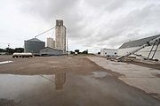
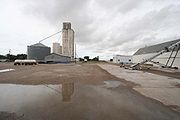 Agriculture, oil, and cattle are Garber's primary industries. Petroleum drilling began as early as 1904-05. The Garber Oil and Gas Company (partly owned by Burton A. Garber) installed Garber's first gas well in 1905. The Garber Field was opened in 1916 when the Hoy well
came in at two hundred barrels per day. Peak production came in November 1925, and by 1940 a well in Section 18, T22N, R3W still held a state record for initial production, 27000 oilbbl/d. Booms happened again in 1925 and 1927 continuing through the 1930s. Three refineries operated by 1929. By 1920 the boom had grown Garber to an unofficial population count of 2,200 (the U.S. Census registered 1,446).
Garfield County, Oklahoma
Garfield County is a county located in the U.S. state of Oklahoma named after President James A. Garfield. As of 2010, the population was 60,580. Enid is the county seat and largest city within Garfield County...
, Oklahoma
Oklahoma
Oklahoma is a state located in the South Central region of the United States of America. With an estimated 3,751,351 residents as of the 2010 census and a land area of 68,667 square miles , Oklahoma is the 28th most populous and 20th-largest state...
, United States
United States
The United States of America is a federal constitutional republic comprising fifty states and a federal district...
. The population was 845 at the 2000 census
United States Census, 2000
The Twenty-second United States Census, known as Census 2000 and conducted by the Census Bureau, determined the resident population of the United States on April 1, 2000, to be 281,421,906, an increase of 13.2% over the 248,709,873 persons enumerated during the 1990 Census...
. The city is named after Martin Garber, father of Milton C. Garber
Milton C. Garber
Milton Cline Garber was a U.S. Representative from Oklahoma. In 1942, he was inducted into the Oklahoma Hall of Fame.-Personal life:...
, former U.S. Congressman, Enid Mayor, newspaper editor, and Judge. The Garber family participated in the Land Run of 1893
Land Run of 1893
The Land Run of 1893, also known as the Cherokee Strip Land Run, marked the opening of the Cherokee Outlet to the public. The run happened on September 16, 1893 at noon with more than 100,000 participants hoping to claim land. The land offices for the run were set up in Perry, Enid, Woodward, and...
, claiming the land that is now Garber, Oklahoma. In October 1899, the Garber Town Company, owned by brothers Milton C. and Burton A. Garber, platted the town.
Geography
Garber is located at 36°26′12"N 97°34′55"W (36.436576, -97.581987).According to the United States Census Bureau
United States Census Bureau
The United States Census Bureau is the government agency that is responsible for the United States Census. It also gathers other national demographic and economic data...
, the city has a total area of 0.5 square miles (1.3 km²), all of it land.
Demographics
As of the censusCensus
A census is the procedure of systematically acquiring and recording information about the members of a given population. It is a regularly occurring and official count of a particular population. The term is used mostly in connection with national population and housing censuses; other common...
of 2000, there were 845 people, 360 households, and 244 families residing in the city. The population density
Population density
Population density is a measurement of population per unit area or unit volume. It is frequently applied to living organisms, and particularly to humans...
was 1,721.2 people per square mile (665.8/km²). There were 447 housing units at an average density of 910.5 per square mile (352.2/km²). The racial makeup of the city was 94.32% White, 0.24% African American, 3.20% Native American, 0.12% Asian, 0.12% from other races
Race (United States Census)
Race and ethnicity in the United States Census, as defined by the Federal Office of Management and Budget and the United States Census Bureau, are self-identification data items in which residents choose the race or races with which they most closely identify, and indicate whether or not they are...
, and 2.01% from two or more races. Hispanic or Latino of any race were 0.24% of the population.
There were 360 households out of which 28.3% had children under the age of 18 living with them, 53.1% were married couples
Marriage
Marriage is a social union or legal contract between people that creates kinship. It is an institution in which interpersonal relationships, usually intimate and sexual, are acknowledged in a variety of ways, depending on the culture or subculture in which it is found...
living together, 10.8% had a female householder with no husband present, and 32.2% were non-families. 31.1% of all households were made up of individuals and 16.7% had someone living alone who was 65 years of age or older. The average household size was 2.35 and the average family size was 2.93.
In the city the population was spread out with 25.8% under the age of 18, 7.8% from 18 to 24, 23.7% from 25 to 44, 23.2% from 45 to 64, and 19.5% who were 65 years of age or older. The median age was 39 years. For every 100 females there were 92.5 males. For every 100 females age 18 and over, there were 88.9 males.
The median income for a household in the city was $25,000, and the median income for a family was $32,778. Males had a median income of $27,417 versus $18,750 for females. The per capita income
Per capita income
Per capita income or income per person is a measure of mean income within an economic aggregate, such as a country or city. It is calculated by taking a measure of all sources of income in the aggregate and dividing it by the total population...
for the city was $13,284. About 8.5% of families and 12.4% of the population were below the poverty line, including 19.5% of those under age 18 and 13.5% of those age 65 or over.
Industry
R. E. Hoy No. 1 Oil Well
The R.E. Hoy No. 1 Oil Well was constructed by the Sinclair Oil & Refining Corporation in September 1916. It has been listed on the National Register of Historic Places since 1986. Milton C. Garber and his brother Bert Garber hired geologist Dorsey Hager to determine potential drilling locations on...
came in at two hundred barrels per day. Peak production came in November 1925, and by 1940 a well in Section 18, T22N, R3W still held a state record for initial production, 27000 oilbbl/d. Booms happened again in 1925 and 1927 continuing through the 1930s. Three refineries operated by 1929. By 1920 the boom had grown Garber to an unofficial population count of 2,200 (the U.S. Census registered 1,446).