Gaua
Encyclopedia
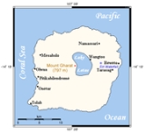
Gaua is the largest of the Banks Islands
in Torba Province
of northern Vanuatu
. It covers 342 km².
(797 m), the peak of the active stratovolcano
at the center of the island. The most recent eruption was in 2011. The volcano has a 6 x 9 km caldera
, within which lies a crater lake
known as Lake Letas
, the largest lake in Vanuatu. To the east of the lake is Siri Waterfall
(120 m drop).
This population is scattered in various coastal villages on the western, southern and northeastern sides of the island. The eastern side has a few hamlets with an immigrant population coming mainly from the two smaller islands Merig
and Merelava
, southeast of Gaua. The largest village is Jolap, on the west coast.
Besides the language of this immigrant population (Mwerlap), there are five languages traditionally spoken on Gaua: Lakon
or Vuré; Olrat; Koro
; Dorig
and Nume.
, combining fishing and horticulture.
The principal exports are copra
and cacao. Gaua has an airport
(code ZGU).
Banks Islands
The Banks Islands are a group of islands in northern Vanuatu.Together with the Torres Islands to the northwest, they make up the northernmost province of Torba. The group lies about north of Maewo, and includes Gaua and Vanua Lava, two of the 13 largest islands in Vanuatu...
in Torba Province
Torba Province
Torba is the northernmost province of Vanuatu, including the Banks Islands and the Torres Islands. Its capital is Sola.The modern name Torba is derived from the initial letters of Torres and Banks.-Facts:...
of northern Vanuatu
Vanuatu
Vanuatu , officially the Republic of Vanuatu , is an island nation located in the South Pacific Ocean. The archipelago, which is of volcanic origin, is some east of northern Australia, northeast of New Caledonia, west of Fiji, and southeast of the Solomon Islands, near New Guinea.Vanuatu was...
. It covers 342 km².
Physical geography
It has rugged terrain, reaching up to Mount GharatMount Gharat
Mount Gharat or Mount Garet is the highest peak on the volcanic island of Gaua of the Banks Islands in northern Vanuatu. The peak is located at the centre of the island, is volcanically active and is surrounded by Lake Letas on all sides except southwest.- References :*...
(797 m), the peak of the active stratovolcano
Stratovolcano
A stratovolcano, also known as a composite volcano, is a tall, conical volcano built up by many layers of hardened lava, tephra, pumice, and volcanic ash. Unlike shield volcanoes, stratovolcanoes are characterized by a steep profile and periodic, explosive eruptions...
at the center of the island. The most recent eruption was in 2011. The volcano has a 6 x 9 km caldera
Caldera
A caldera is a cauldron-like volcanic feature usually formed by the collapse of land following a volcanic eruption, such as the one at Yellowstone National Park in the US. They are sometimes confused with volcanic craters...
, within which lies a crater lake
Crater lake
A crater lake is a lake that forms in a volcanic crater or caldera, such as a maar; less commonly and with lower association to the term a lake may form in an impact crater caused by a meteorite. Sometimes lakes which form inside calderas are called caldera lakes, but often this distinction is not...
known as Lake Letas
Lake Letas
Lake Letas is the largest lake in Vanuatu, located in the center of the volcanic island of Gaua of the Banks Islands in northern Vanuatu. The place submitted an application to be considered an UNESCO World Heritage Site in 2004....
, the largest lake in Vanuatu. To the east of the lake is Siri Waterfall
Siri Waterfall
Siri Waterfall, formerly called Santa Maria Waterfall, is a 120 metre high waterfall located about 3 km inland from the eastern coast of the island of Gaua in northern Vanuatu....
(120 m drop).
Population and languages
The island has a population of 2491 (in 2009), with an annual growth rate of 2.0 percent.This population is scattered in various coastal villages on the western, southern and northeastern sides of the island. The eastern side has a few hamlets with an immigrant population coming mainly from the two smaller islands Merig
Merig
Merig is a small island located 20 km east of Gaua, in the Banks Islands of northern Vanuatu.The island is about 800 meters wide, and has a circumference of 2.2 km....
and Merelava
Merelava
Merelava is an island in the Banks Islands of northern Vanuatu. It is situated in the southeastern part of the archipelago near Mota and Merig. The island is administratively part of Torba Province. Merelava has also been known as Star Island. It is located about 50 km east of Gaua.-Population and...
, southeast of Gaua. The largest village is Jolap, on the west coast.
Besides the language of this immigrant population (Mwerlap), there are five languages traditionally spoken on Gaua: Lakon
Lakon language
External links=* in Lakon from Project Canterbury* *...
or Vuré; Olrat; Koro
Koro language (Vanuatu)
-External links:* ....
; Dorig
Dorig language
-External links:* .* ....
and Nume.
Economy
The population of Gaua lives of the traditional agricultural economy of MelanesiaMelanesia
Melanesia is a subregion of Oceania extending from the western end of the Pacific Ocean to the Arafura Sea, and eastward to Fiji. The region comprises most of the islands immediately north and northeast of Australia...
, combining fishing and horticulture.
The principal exports are copra
Copra
Copra is the dried meat, or kernel, of the coconut. Coconut oil extracted from it has made copra an important agricultural commodity for many coconut-producing countries. It also yields coconut cake which is mainly used as feed for livestock.-Production:...
and cacao. Gaua has an airport
Gaua Airport
Gaua Airport is an airport on the island of Gaua, one of the Banks Islands in the Torba province in Vanuatu....
(code ZGU).

