Gehn
Encyclopedia

Bramsche
Bramsche is a town in the district of Osnabrück, Lower Saxony, Germany. It is about 20 km north of Osnabrück, at . Population is 30858 .In 1971/72 12 previously independent municipalities were included into the town.*Achmer*Balkum...
and Ueffeln in Germany's Central Uplands
Central Uplands
The Central Uplands is one of the three major natural regions of Germany and covers most of the land area of the country. To the north lies the North German Plain or Northern Lowland; to the south, the Alps and the Alpine Foreland.- Formation :...
, that are an extension of the Wiehen Hills .
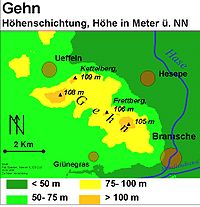
The ridge runs from northwest to southeast and is about 5 kilometres (3.1 mi) long and an average of 2 kilometres (1.2 mi) wide. The highest point is the Kettelberg which is high. The Gehn forms a link between the Wiehen Hills and the Ankum Heights
Ankum Heights
The Ankum Heights , also called the Fürstenau Hills , are a ridge of hills up to 140 m high in the western part of the state of Lower Saxony on the North German Plain.- Geography :...
(Ankumer Höhe). It is largely forested and is not - like the Ankum Heights- part of a series of ice age
Ice age
An ice age or, more precisely, glacial age, is a generic geological period of long-term reduction in the temperature of the Earth's surface and atmosphere, resulting in the presence or expansion of continental ice sheets, polar ice sheets and alpine glaciers...
terminal moraine
Terminal moraine
A terminal moraine, also called end moraine, is a moraine that forms at the end of the glacier called the snout.Terminal moraines mark the maximum advance of the glacier. An end moraine is at the present boundary of the glacier....
s from the latest event of the Saalian glaciation, the so-called Drenthe I stage, but is a ridge of Jurassic rock that was pushed up during the folding towards the end of the Cretaceous
Cretaceous
The Cretaceous , derived from the Latin "creta" , usually abbreviated K for its German translation Kreide , is a geologic period and system from circa to million years ago. In the geologic timescale, the Cretaceous follows the Jurassic period and is followed by the Paleogene period of the...
period.
Like the Wiehen Hills and the Ankum Heights, the Gehn belongs to the North Teutoburg Forest-Wiehen Hills Nature Park (Naturpark Nördlicher Teutoburger Wald-Wiehengebirge).
Elevations
Amongst the main elevations on the Gehn are the:- Kettelsberg
- Gehnberg (108.1 m)
- Heseper Berg (107.9 m)
- Frettberg (105.9 m)

