

Geography of Botswana
Encyclopedia
Botswana
Botswana, officially the Republic of Botswana , is a landlocked country located in Southern Africa. The citizens are referred to as "Batswana" . Formerly the British protectorate of Bechuanaland, Botswana adopted its new name after becoming independent within the Commonwealth on 30 September 1966...
is a landlocked country located in Southern Africa
Africa
Africa is the world's second largest and second most populous continent, after Asia. At about 30.2 million km² including adjacent islands, it covers 6% of the Earth's total surface area and 20.4% of the total land area...
, north of South Africa
South Africa
The Republic of South Africa is a country in southern Africa. Located at the southern tip of Africa, it is divided into nine provinces, with of coastline on the Atlantic and Indian oceans...
. Botswana
Botswana
Botswana, officially the Republic of Botswana , is a landlocked country located in Southern Africa. The citizens are referred to as "Batswana" . Formerly the British protectorate of Bechuanaland, Botswana adopted its new name after becoming independent within the Commonwealth on 30 September 1966...
occupies an area of 600,370 square kilometres, of which 585,000 km² are land. Botswana has land boundaries of combined length 4,013 kilometres, of which the constituent boundaries are shared with Namibia
Namibia
Namibia, officially the Republic of Namibia , is a country in southern Africa whose western border is the Atlantic Ocean. It shares land borders with Angola and Zambia to the north, Botswana to the east and South Africa to the south and east. It gained independence from South Africa on 21 March...
, for 1,360 km; South Africa
South Africa
The Republic of South Africa is a country in southern Africa. Located at the southern tip of Africa, it is divided into nine provinces, with of coastline on the Atlantic and Indian oceans...
1,840 km; Zimbabwe
Zimbabwe
Zimbabwe is a landlocked country located in the southern part of the African continent, between the Zambezi and Limpopo rivers. It is bordered by South Africa to the south, Botswana to the southwest, Zambia and a tip of Namibia to the northwest and Mozambique to the east. Zimbabwe has three...
, 813 km and Zambia
Zambia
Zambia , officially the Republic of Zambia, is a landlocked country in Southern Africa. The neighbouring countries are the Democratic Republic of the Congo to the north, Tanzania to the north-east, Malawi to the east, Mozambique, Zimbabwe, Botswana and Namibia to the south, and Angola to the west....
, less than 1 km. Much of the population of Botswana is concentrated in the eastern part of the country.
|1}}. Sunshine totals are high all year round although winter is the sunniest period. The whole country is windy and dusty during the dry season.
Climate
Botswana is semi-arid, due to the short rain season. However, the relatively high altitude of the country and its continental situation gives it a subtropical climate. The country is remote from moisture-laden air flows for most of the year. The dry season lasts from April to October in the south and to November in the north where, however, rainfall totals are higher. The south of the country is most exposed to cold winds during the winter period (early May to late August) when average temperatures are around 14 °C (57.2 °F). The whole country has hot summers with average temperatures around 26 °C (78.8 °F). Sunshine totals are high all year round although winter is the sunniest period. The whole country is windy and dusty during the dry season.
Orography
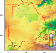
The land is predominantly flat to gently undulating tableland, although there is some hilly country, where mining is carried out. The Kalahari DesertKalahari Desert
The Kalahari Desert is a large semi-arid sandy savannah in Southern Africa extending , covering much of Botswana and parts of Namibia and South Africa, as semi-desert, with huge tracts of excellent grazing after good rains. The Kalahari supports more animals and plants than a true desert...
is in the central and the southwest. The Okavango Delta
Okavango Delta
The Okavango Delta , in Botswana, is the world's largest inland delta. It is formed where the Okavango River empties onto a swamp in an endorheic basin in the Kalahari Desert, where most of the water is lost to evaporation and transpiration instead of draining into the sea...
, the world's largest inland delta, is in the northwest and the Makgadikgadi Pans, a large salt pan
Salt pan (geology)
Natural salt pans are flat expanses of ground covered with salt and other minerals, usually shining white under the sun. They are found in deserts, and should not be confused with salt evaporation ponds.A salt pan is formed where water pools...
lies in the north-central area. The Makgadikgadi has been established as an early habitation area for primitive man; This large seasonal wetland
Wetland
A wetland is an area of land whose soil is saturated with water either permanently or seasonally. Wetlands are categorised by their characteristic vegetation, which is adapted to these unique soil conditions....
is composed of several large component pans, the largest being Nwetwe Pan
Nwetwe Pan
The Nwetwe Pan is a large salt pan within the Makgadikgadi region of Botswana. The Nwetwe is one of three large pans within the Makgadikgadi, the other two being Nxai Pan and Sua Pan. In the present day Nwetwe Pan is a seasonal lake with filling occurring in the rainy season. Nwetwe was first...
, Sua Pan
Sua Pan
The Sua Pan or Sowa Pan is a large natural topographic depression within the Makgadikgadi region of Botswana. It is located near the village of Sowa, whose name means salt in the language of the San...
and Nxai Pan
Nxai Pan
Nxai Pan is a large salt pan topographic depression which is part of the larger Makgadikgadi Pans in northeastern Botswana. This landform is a major part of the Nxai Pan National Park, and is a seasonal home to large herds of zebra...
. Botswana's lowest elevation point is at the junction of the Limpopo
Limpopo River
The Limpopo River rises in central southern Africa, and flows generally eastwards to the Indian Ocean. It is around long, with a drainage basin in size. Its mean annual discharge is 170 m³/s at its mouth...
and Shashe Rivers, at a height of 513 m. The highest point is Monalanong Hill
Monalanong Hill
Monalanong Hill is a mountain often considered the highest point of Botswana, with a questioned altitude of 1,494 metres .The Otse Hill or the Tsodilo Hills are also often given as the highest point in Botswana....
, at 1,494 m.
The country is divided into four drainage regions, which are sometimes indistinct due to the arid nature of the climate:
- the Chobe River on the border with the Caprivi StripCaprivi StripCaprivi, sometimes called the Caprivi Strip , Caprivi Panhandle or the Okavango Strip and formally known as Itenge, is a narrow protrusion of Namibia eastwards about , between Botswana to the south, Angola and Zambia to the north, and Okavango Region to the west. Caprivi is bordered by the...
of Namibia together with a small adjacent swampy area is part of the ZambeziZambeziThe Zambezi is the fourth-longest river in Africa, and the largest flowing into the Indian Ocean from Africa. The area of its basin is , slightly less than half that of the Nile...
basin; - most of the north and central region of the country is part of the OkavangoOkavangoOkavango may refer to:* Okavango River, in southwest Africa, which drains into the Okavango Delta* Okavango Basin, an endorheic basin that includes the Okavango River and Okavango Delta.* Okavango Region, a region of Namibia...
inland drainage basin; - the easternmost part of the country falls into the LimpopoLimpopoLimpopo is the northernmost province of South Africa. The capital is Polokwane, formerly named Pietersburg. The province was formed from the northern region of Transvaal Province in 1994, and initially named Northern Transvaal...
drainage basin; - the southern and southwestern regions, which are the driest of all, are drained by the Molopo river along the South African border and the Nossob riverNossob RiverThe Nossob River is a dry river bed in eastern Namibia and the Kalahari region of South Africa and Botswana. It covers a distance of 740km and last flooded in 1989...
through the Kalahari Gemsbok National ParkKgalagadi Transfrontier ParkKgalagadi Transfrontier Park is a large wildlife preserve and conservation area in southern Africa. The park straddles the border between South Africa and Botswana and comprises two adjoining national parks: Kalahari Gemsbok National Park in South Africa and Gemsbok National Park in Botswana. The...
, and are technically part of the basin of the Orange riverOrange RiverThe Orange River , Gariep River, Groote River or Senqu River is the longest river in South Africa. It rises in the Drakensberg mountains in Lesotho, flowing westwards through South Africa to the Atlantic Ocean...
. None of these rivers normally flows as far as the Orange, however. (The last recorded confluence was in the 1880s.)
Except for the Chobe, Okavango, Boteti and Limpopo river
Limpopo River
The Limpopo River rises in central southern Africa, and flows generally eastwards to the Indian Ocean. It is around long, with a drainage basin in size. Its mean annual discharge is 170 m³/s at its mouth...
s, most of Botswana's rivers cease to flow during the dry and early rainy seasons.
Natural hazards
Botswana is affected by periodic droughts, and seasonal August winds blow from the west, carrying sand and dust, which can obscure visibility.Environment
Current environmental issues in Botswana are overgrazing, desertification and the existence of only limited fresh water resources.Research from the University of Botswana
University of Botswana
The University of Botswana, or UB was established in 1982 as the first institution of higher education in Botswana. The university has four campuses: two in the capital city Gaborone, one in Francistown, and another in Maun. The university is divided into six faculties: Business, Education,...
has found that the common practice of overstocking cattle to cope with drought losses actually depletes scarce biomass
Biomass
Biomass, as a renewable energy source, is biological material from living, or recently living organisms. As an energy source, biomass can either be used directly, or converted into other energy products such as biofuel....
, making ecosystems more vulnerable. The study of the Kgatleng district predicts that by 2050 the cycle of mild drought is likely to become shorter —18 months instead of two years—due to climate change
Climate change
Climate change is a significant and lasting change in the statistical distribution of weather patterns over periods ranging from decades to millions of years. It may be a change in average weather conditions or the distribution of events around that average...
.
International agreements
Botswana is a party to the following international agreements: Diamond Industry, Biodiversity, Climate Change, Desertification, Endangered Species, Hazardous Wastes, Law of the Sea, Nuclear Test Ban, Ozone Layer Protection and Wetlands.Extreme points
This is a list of the extreme points of BotswanaBotswana
Botswana, officially the Republic of Botswana , is a landlocked country located in Southern Africa. The citizens are referred to as "Batswana" . Formerly the British protectorate of Bechuanaland, Botswana adopted its new name after becoming independent within the Commonwealth on 30 September 1966...
, the points that are farther north, south, east or west than any other location.
- Northernmost point - the tripointTripointA tripoint, or trijunction , is a geographical point at which the borders of three countries or subnational entities meet....
with ZambiaZambiaZambia , officially the Republic of Zambia, is a landlocked country in Southern Africa. The neighbouring countries are the Democratic Republic of the Congo to the north, Tanzania to the north-east, Malawi to the east, Mozambique, Zimbabwe, Botswana and Namibia to the south, and Angola to the west....
and NamibiaNamibiaNamibia, officially the Republic of Namibia , is a country in southern Africa whose western border is the Atlantic Ocean. It shares land borders with Angola and Zambia to the north, Botswana to the east and South Africa to the south and east. It gained independence from South Africa on 21 March...
, Ngamiland District - Easternmost point - the tripointTripointA tripoint, or trijunction , is a geographical point at which the borders of three countries or subnational entities meet....
with South AfricaSouth AfricaThe Republic of South Africa is a country in southern Africa. Located at the southern tip of Africa, it is divided into nine provinces, with of coastline on the Atlantic and Indian oceans...
and ZimbabweZimbabweZimbabwe is a landlocked country located in the southern part of the African continent, between the Zambezi and Limpopo rivers. It is bordered by South Africa to the south, Botswana to the southwest, Zambia and a tip of Namibia to the northwest and Mozambique to the east. Zimbabwe has three...
, Central DistrictCentral District (Botswana)Central is the largest of Botswana's districts in terms of area and population. It encompasses the traditional homeland of the Bamangwato people. Some of the most politically connected Batswana have come from the Central District, including former President Sir Seretse Khama, former President... - Southernmost point - BokspitsBokspitsBokspits is a village in Kgalagadi District of Botswana. It is the southernmost village in Botswana and is located close to the border with South Africa. Bokspits has a primary school and a clinic. The population was 499 in 2001 census.-References:...
, Kgalagadi District - Westernmost point - the western section of the border with NamibiaNamibiaNamibia, officially the Republic of Namibia , is a country in southern Africa whose western border is the Atlantic Ocean. It shares land borders with Angola and Zambia to the north, Botswana to the east and South Africa to the south and east. It gained independence from South Africa on 21 March...
*
- Note: Botswana does not have a westernmost point as the western section is formed by the 22nd meridian of longitude east of Greenwich.