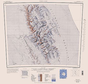
Gildea Glacier
Encyclopedia

Craddock Massif
Craddock Massif is a mountain massif in the Sentinel Range of the Ellsworth Mountains, in the Chilean claim of West Antarctica.-Location and highest point:...
between Mount Slaughter
Mount Slaughter
Mount Slaughter is an ice-free peak, rising to 3,600 m on a spur trending southwest from Opalchenie Peak on Vinson Plateau, Sentinel Range, in the Ellsworth Mountains, Antarctica. It is surmounting the head of Donnellan Glacier to the northwest and Gildea Glacier to the south. Mapped by United...
and Mount Atkinson into Nimitz Glacier
Nimitz Glacier
The Nimitz Glacier is an Antarctic glacier, 64 km long and 8 km wide, draining the area about 16 km west of the Vinson Massif and flowing southeast between the Sentinel Range and Bastien Range to enter Minnesota Glacier, in the central Ellsworth Mountains.Discovered by USN...
, Sentinel Range
Sentinel Range
The Sentinel Range is a major mountain range situated northward of Minnesota Glacier and forming the northern half of the Ellsworth Mountains in Antarctica. The range trends NNW-SSE for about and is 24 to 48 km wide...
, Ellsworth Mountains
Ellsworth Mountains
The Ellsworth Mountains are the highest mountain ranges in Antarctica, forming a long and wide chain of mountains in a north to south configuration on the western margin of the Ronne Ice Shelf. They are bisected by Minnesota Glacier to form the northern Sentinel Range and the southern Heritage...
. The upper portion of the glacier also receives ice from Hammer Col
Hammer Col
Hammer Col is a broad ice-covered col at 3800 m elevation between the south part of Vinson Massif and the Craddock Massif in the Sentinel Range, Ellsworth Mountains...
and southern Vinson Massif
Vinson Massif
Vinson Massif is the highest mountain of Antarctica, lying in the Sentinel Range of the Ellsworth Mountains, which stand above the Ronne Ice Shelf near the base of the Antarctic Peninsula. The massif is located about from the South Pole and is about long and wide. At the highest point is Mount...
.
Named by the US Advisory Committee on Antarctic Names
Advisory Committee on Antarctic Names
The Advisory Committee on Antarctic Names is an advisory committee of the United States Board on Geographic Names responsible for recommending names for features in Antarctica...
after Damien Gildea
Damien Gildea
Damien Gildea is an Australian mountaineer and Antarctic explorer who climbed extensively in Antarctica, Nepal, Tibet, Pakistan, Bolivia, Alaska, New Zealand and elsewhere...
, Australia
Australia
Australia , officially the Commonwealth of Australia, is a country in the Southern Hemisphere comprising the mainland of the Australian continent, the island of Tasmania, and numerous smaller islands in the Indian and Pacific Oceans. It is the world's sixth-largest country by total area...
n leader of several Omega Foundation expeditions to Sentinel Range
Sentinel Range
The Sentinel Range is a major mountain range situated northward of Minnesota Glacier and forming the northern half of the Ellsworth Mountains in Antarctica. The range trends NNW-SSE for about and is 24 to 48 km wide...
and Livingston Island in 2000-2007. He made an ascent of Mount Craddock
Mount Craddock
Mount Craddock is a large, bold mountain forming the south extremity of Craddock Massif in Sentinel Range, the highest mountain in Antarctica. It is linked by Karnare Col to Mount Strybing in the southern Sentinel Range...
via this glacier in 2005, and directed the preparation of a 1:50,000-scale map of the Vinson Massif area for publication by the Omega Foundation in 2006.
Reference
- Gildea Glacier. Geographic Names Information SystemGeographic Names Information SystemThe Geographic Names Information System is a database that contains name and locative information about more than two million physical and cultural features located throughout the United States of America and its territories. It is a type of gazetteer...
, USGS.

