Glacier mass balance
Encyclopedia

Glacier
A glacier is a large persistent body of ice that forms where the accumulation of snow exceeds its ablation over many years, often centuries. At least 0.1 km² in area and 50 m thick, but often much larger, a glacier slowly deforms and flows due to stresses induced by its weight...
is its mass balance, the difference between accumulation
Glacier ice accumulation
Glacier ice accumulation occurs through accumulation of snow and other frozen precipitation, as well as through other means including rime ice , avalanching from hanging glaciers on cliffs and mountainsides above, and re-freezing of glacier meltwater as superimposed ice...
and ablation
Ablation zone
Ablation zone refers to the low altitude area of a glacier or ice sheet where there is a net loss in ice mass due to melting, sublimation, evaporation, or calving. The ablation zone is delineated by the equilibrium line altitude , or snow line, which separates the ablation zone and the high...
(melting and sublimation). Climate change
Climate change
Climate change is a significant and lasting change in the statistical distribution of weather patterns over periods ranging from decades to millions of years. It may be a change in average weather conditions or the distribution of events around that average...
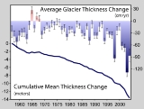
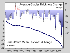
may cause variations in both temperature and snowfall, causing changes in mass balance. Changes in mass balance control a glacier's long term behavior and is the most sensitive climate indicator on a glacier. From 1980-2008 the mean cumulative mass loss of glaciers reporting mass balance to the World Glacier Monitoring Service is -12 m. This includes 19 consecutive years of negative mass balances.
A glacier with a sustained negative balance is out of equilibrium and will retreat, while one with a sustained positive balance is out of equilibrium and will advance. Glacier retreat results in the loss of the low elevation region of the glacier. Since higher elevations are cooler than lower ones, the disappearance of the lowest portion of the glacier reduces overall ablation, thereby increasing mass balance and potentially reestablishing equilibrium. However, if the mass balance of a significant portion of the accumulation zone of the glacier is negative, it is in disequilibrium with the local climate. Such a glacier will melt away with a continuation of this local climate.
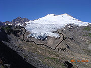
The key symptom of a glacier in disequilibrium is thinning along the entire length of the glacier. For example, Easton Glacier (pictured below) will likely shrink to half its size, but at a slowing rate of reduction, and stabilize at that size, despite the warmer temperature, over a few decades. However, the Grinnell Glacier
Grinnell Glacier
Grinnell Glacier is located in the heart of Glacier National Park in the U.S. state of Montana. The glacier is named for George Bird Grinnell, an early American conservationist and explorer, who was also a strong advocate of ensuring the creation of Glacier National Park...
(pictured below) will shrink at an increasing rate until it disappears. The difference is that the upper section of Easton Glacier remains healthy and snow-covered, while even the upper section of the Grinnell Glacier is bare, melting and has thinned. Small glaciers with shallow slopes such as Grinnell Glacier are most likely to fall into disequilibrium if there is a change in the local climate.
In the case of positive mass balance, the glacier will continue to advance expanding its low elevation area, resulting in more melting. If this still does not create an equilibrium balance the glacier will continue to advance. If a glacier is near a large body of water, especially an ocean, the glacier may advance until iceberg calving
Ice calving
Ice calving, also known as glacier calving or iceberg calving, is a form of ice ablation or ice disruption. It is the sudden release and breaking away of a mass of ice from a glacier, iceberg, ice front, ice shelf, or crevasse...
losses bring about equilibrium.
Measurement methods

Mass balance
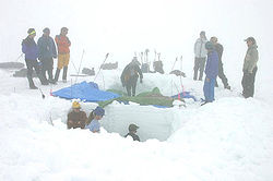
Mass balance is measured by determining the amount of snow accumulated during winter, and later measuring the amount of snow and ice removed by melting in the summer. The difference between these two parameters is the mass balance. If the amount of snow accumulated during the winter is larger than the amount of melted snow and ice during the summer, the mass balance is positive and the glacier has increased in volume. On the other hand, if the melting of snow and ice during the summer is larger than the supply of snow in the winter, the mass balance is negative and the glacier volume decreases. Mass balance is reported in meters of water equivalent. This represents the average thickness gained (positive balance) or lost (negative balance) from the glacier during that particular year.To determine mass balance in the accumulation zone, snowpack depth is measured using probing, snowpits or crevasse
Crevasse
A crevasse is a deep crack in an ice sheet rhys glacier . Crevasses form as a result of the movement and resulting stress associated with the sheer stress generated when two semi-rigid pieces above a plastic substrate have different rates of movement...
stratigraphy. Crevasse stratigraphy makes use of annual layers revealed on the wall of a crevasse. Akin to tree rings, these layers are due to summer dust deposition and other seasonal effects. The advantage of crevasse stratigraphy
Stratigraphy
Stratigraphy, a branch of geology, studies rock layers and layering . It is primarily used in the study of sedimentary and layered volcanic rocks....
is that it provides a two-dimensional measurement of the snowpack layer, not a point measurement. It is also usable in depths where probing or snowpits are not feasible. In temperate glaciers, the insertion resistance of a probe increases abruptly when its tip reaches ice that was formed the previous year. The probe depth is a measure of the net accumulation above that layer. Snowpits dug through the past winters residual snowpack are used to determine the snowpack depth and density. The snowpack's mass balance is the product of density and depth. Regardless of depth measurement technique the observed depth is multiplied by the snowpack density to determine the accumulation in water equivalent. It is necessary to measure the density in the spring as snowpack density varies. Measurement of snowpack density completed at the end of the ablation season yield consistent values for a particular area on temperate alpine glaciers and need not be measured every year. In the ablation zone, ablation measurements are made using stakes inserted vertically into the glacier either at the end of the previous melt season or the beginning of the current one. The length of stake exposed by melting ice is measured at the end of the melt (ablation) season. Most stakes must be replaced each year or even mid-way through the summer.

Net balance
Net balance is the mass balance determined between successive mass balance minimums. This is the stratigraphic method focusing on the minima representing a stratigraphic horizon. In the northern mid-latitudes, a glacier's year follows the hydrologic year, starting and ending near the beginning of October. The mass balance minimum is the end of the melt season. The net balance is then the sum of the observed winter balance (bw) normally measured in April or May and summer balance (bs) measured in September or early October.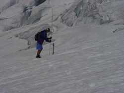
Annual balance
Annual balance is the mass balance measured between specific dates. The mass balance is measured on the fixed date each year, again sometime near the start of October in the mid northern latitudes.Geodetic methods
Geodetic methods are an indirect method for the determination of mass balance of glacier. Maps of a glacier made at two different points in time can be compared and the difference in glacier thickness observed used to determine the mass balance over a span of years. This is best accomplished today using Differential Global Positioning SystemGlobal Positioning System
The Global Positioning System is a space-based global navigation satellite system that provides location and time information in all weather, anywhere on or near the Earth, where there is an unobstructed line of sight to four or more GPS satellites...
. Sometimes the earliest data for the glacier surface profiles is from images that are used to make topographical maps and digital elevation model
Digital elevation model
A digital elevation model is a digital model or 3-D representation of a terrain's surface — commonly for a planet , moon, or asteroid — created from terrain elevation data....
s. Aerial mapping or photogrammetry
Photogrammetry
Photogrammetry is the practice of determining the geometric properties of objects from photographic images. Photogrammetry is as old as modern photography and can be dated to the mid-nineteenth century....
is now used to cover larger glaciers and icecaps such found in Antarctica and Greenland
Greenland
Greenland is an autonomous country within the Kingdom of Denmark, located between the Arctic and Atlantic Oceans, east of the Canadian Arctic Archipelago. Though physiographically a part of the continent of North America, Greenland has been politically and culturally associated with Europe for...
, however, because of the problems of establishing accurate ground control points in mountainous terrain, and correlating features in snow and where shading is common, elevation errors are typically not less than 10 m (32 ft). Laser altimetry provides a measurement of the elevation of a glacier along a specific path, e.g., the glacier centerline. The difference of two such measurements is the change in thickness, which provides mass balance over the time interval between the measurements. Again a good method over a span of time but not for annual change detection. The value of geodetic programs is providing an independent check of traditional mass balance work, by comparing the cumulative changes over ten or more years.
Mass balance research worldwide
Mass balance studies have been carried out in various countries worldwide, but have mostly conducted in the Northern HemisphereNorthern Hemisphere
The Northern Hemisphere is the half of a planet that is north of its equator—the word hemisphere literally means “half sphere”. It is also that half of the celestial sphere north of the celestial equator...
due to there being more mid-latitude glaciers in that hemisphere. The World Glacier Monitoring Service annually compiles the mass balance measurements from around the world. From 2002-2006, continuous data is available for only 7 glaciers in the southern hemisphere and 76 glaciers in the Northern Hemisphere. The mean balance of these glaciers was its most negative in any year for 2005/06. The similarity of response of glaciers in western North America indicates the large scale nature of the driving climate change.
Alaska
The Taku GlacierTaku Glacier
Taku Glacier is a tidewater glacier located in Taku Inlet in the U.S. state of Alaska, just southeast of the city of Juneau. Recognized as the deepest and thickest glacier known in the world, the Taku Glacier is measured at ....
near Juneau, Alaska
Juneau, Alaska
The City and Borough of Juneau is a unified municipality located on the Gastineau Channel in the panhandle of the U.S. state of Alaska. It has been the capital of Alaska since 1906, when the government of the then-District of Alaska was moved from Sitka as dictated by the U.S. Congress in 1900...
has been studied by the Juneau Icefield Research Program since 1946, and is the longest continuous mass balance study of any glacier in North America
North America
North America is a continent wholly within the Northern Hemisphere and almost wholly within the Western Hemisphere. It is also considered a northern subcontinent of the Americas...
. Taku is the world's thickest known temperate alpine glacier, and experienced positive mass balance between the years 1946 and 1988, resulting in a huge advance. The glacier has since been in a negative mass balance state, which may result in a retreat if the current trends continue. The Juneau Icefield Research Program also has studied the mass balance of the Lemon Creek Glacier since 1953. The glacier has had an average annual balance of -0.44 m per year from 1953–2006, resulting in a mean loss of over 27 m of ice thickness. This loss has been confirmed by laser altimetry.
Austrian Glacier Mass Balance
The mass balance of Hintereisferner and Kesselwandferner glaciers in AustriaAustria
Austria , officially the Republic of Austria , is a landlocked country of roughly 8.4 million people in Central Europe. It is bordered by the Czech Republic and Germany to the north, Slovakia and Hungary to the east, Slovenia and Italy to the south, and Switzerland and Liechtenstein to the...
have been continuously monitored since 1952 and 1965 respectively. Having been continuously measured for 55 years, Hintereisferner has one of the longest periods of continuous study of any glacier in the world, based on measured data and a consistent method of evaluation. Currently this measurement network comprises about 10 snow pits and about 50 ablation stakes distributed across the glacier. In terms of the cumulative specific balances, Hintereisferner experienced a net loss of mass between 1952 and 1964, followed by a period of recovery till 1968. Hintereisferner reached an intermittent minimum in 1976, briefly recovered in 1977 and 1978 and has continuously lost mass in the 30 years since then. Total mass loss has been 26 m since 1952 Sonnblickkees Glacier has been measured since 1957 and the glacier has lost 12 m of mass, an average annual loss of -0.23 m per year.
New Zealand
Glacier mass balance studies have been ongoing in New ZealandNew Zealand
New Zealand is an island country in the south-western Pacific Ocean comprising two main landmasses and numerous smaller islands. The country is situated some east of Australia across the Tasman Sea, and roughly south of the Pacific island nations of New Caledonia, Fiji, and Tonga...
since 1957. Tasman Glacier
Tasman Glacier
The Tasman Glacier is the largest of several glaciers which flow south and east towards the Mackenzie Basin from the Southern Alps in New Zealand's South Island. It is New Zealand's longest glacier.-Geography:...
has been studied since then by the New Zealand Geological Survey and later by the Ministry of Works, measuring the ice stratigraphy and overall movement. However, even earlier fluctuation patterns were documented on Franz Josef
Franz Josef Glacier
The Franz Josef is a long glacier located in Westland Tai Poutini National Park on the West Coast of New Zealand's South Island...
and Fox Glacier
Fox Glacier
The Fox Glacier is a long glacier located in Westland Tai Poutini National Park on the West Coast of New Zealand's South Island...
s in 1950. Other glaciers on the South Island
South Island
The South Island is the larger of the two major islands of New Zealand, the other being the more populous North Island. It is bordered to the north by Cook Strait, to the west by the Tasman Sea, to the south and east by the Pacific Ocean...
studied include Ivory Glacier since 1968, while on the North Island
North Island
The North Island is one of the two main islands of New Zealand, separated from the much less populous South Island by Cook Strait. The island is in area, making it the world's 14th-largest island...
, glacier retreat and mass balance research has been conducted on the glaciers on Mount Ruapehu
Mount Ruapehu
Mount Ruapehu, or just Ruapehu, is an active stratovolcano at the southern end of the Taupo Volcanic Zone in New Zealand. It is 23 kilometres northeast of Ohakune and 40 kilometres southwest of the southern shore of Lake Taupo, within Tongariro National Park...
since 1955. On Mount Ruapehu, permanent photographic stations allow repeat photography to be used to provide photographic evidence of changes to the glaciers on the mountain over time.
An aerial photographic survey of 50 glaciers in the South Island has been carried out for most years since 1977. The data was used to show that between 1976 and 2005 there was a 10% loss in glacier volume.
North Cascade glacier mass balance program
The North Cascade Glacier Climate Project measures the annual balance of 10 glaciers, more than any other program in North America. These records extend from 1984–2008 and represent the only set of records documenting the mass balance changes of an entire glacier clad range. To monitor an entire glaciated mountain range in North America, which was listed as a high priority of the National Academy of Sciences in 1983. North Cascade glaciers annual balance has averaged −0.48 m/a from 1984–2008, a cumulative thickness loss of over 13 m or 20–40% of their total volume since 1984 due to negative mass balances. The trend in mass balance is becoming more negative which is fueling more glacier retreat and thinning.Norway mass balance program
NorwayNorway
Norway , officially the Kingdom of Norway, is a Nordic unitary constitutional monarchy whose territory comprises the western portion of the Scandinavian Peninsula, Jan Mayen, and the Arctic archipelago of Svalbard and Bouvet Island. Norway has a total area of and a population of about 4.9 million...
maintains the most extensive mass balance program in the world and is largely funded by the hydropower industry. Mass balance measurements are currently performed on twelve glaciers in Norway. In southern Norway six of the glaciers have been measured for 42 consecutive years or more, and they constitute a west-east profile reaching from the very maritime Ålfotbreen Glacier, close to the western coast, to the very continental Gråsubreen Glacier, in the eastern part of Jotunheimen
Jotunheimen
Jotunheimen is a mountainous area of roughly 3,500 km² in Southern Norway and is part of the long range known as the Scandinavian Mountains. The 29 highest mountains in Norway are all in Jotunheimen, including the very highest - Galdhøpiggen...
. Storbreen Glacier in Jotunheimen has been measured for a longer period of time than any other glacier in Norway, a total of over 55 years, while Engabreen Glacier has the longest series (35 years) in northern Norway. The Norwegian program is where the traditional methods of mass balance measurement were largely derived.
Sweden Storglaciären
The Tarfala Research Station in the KebnekaiseKebnekaise
Kebnekaise is the highest mountain in Sweden and Sápmi. The Kebnekaise massif, which is part of the Scandinavian Mountains, has two peaks, of which the southern, glaciated one is highest at above sea level at the latest time of measurement. The north top is free of ice...
region of northern Sweden
Sweden
Sweden , officially the Kingdom of Sweden , is a Nordic country on the Scandinavian Peninsula in Northern Europe. Sweden borders with Norway and Finland and is connected to Denmark by a bridge-tunnel across the Öresund....
is operated by Stockholm University
Stockholm University
Stockholm University is a state university in Stockholm, Sweden. It has over 28,000 students at four faculties, making it one of the largest universities in Scandinavia. The institution is also frequently regarded as one of the top 100 universities in the world...
. It was here that the first mass balance program was initiated immediately after World War II
World War II
World War II, or the Second World War , was a global conflict lasting from 1939 to 1945, involving most of the world's nations—including all of the great powers—eventually forming two opposing military alliances: the Allies and the Axis...
, and continues to the present day. This survey was the initiation of the mass balance record of Storglaciären Glacier, and constitutes the longest continuous study of this type in the world. Storglaciären has had a cumulative negative mass balance from 1946-2006 of -17 m. The program began monitoring the Rabots Glaciär in 1982, Riukojietna in 1985, and Mårmaglaciären in 1988. All three of these glaciers have had a strong negative mass balance since initiation.
Iceland Glacier mass balance
Glacier mass balance is measured once or twice annually on numerous stakes on the several ice caps in Iceland by the National Energy Authority. Regular pit and stake mass-balance measurements have been carried out on the northern side of Hofsjökull since 1988 and likewise on the Þrándarjökull since 1991. Profiles of mass balance (pit and stake) have been established on the eastern and south-western side of Hofsjökull since 1989. Similar profiles have been assessed on the Tungnaárjökull, Dyngjujökull, Köldukvíslarjökull and Brúarjökull outlet glaciers of Vatnajökull since 1992 and the Eyjabakkajökull outlet glacier since 1991.Swiss mass balance program
Temporal changes in the spatial distribution of the mass balance result primarily from changes in accumulation and melt along the surface. As a consequence, variations in the mass of glaciers reflect changes in climate and the energy fluxes at the Earth's surface. The SwissSwitzerland
Switzerland name of one of the Swiss cantons. ; ; ; or ), in its full name the Swiss Confederation , is a federal republic consisting of 26 cantons, with Bern as the seat of the federal authorities. The country is situated in Western Europe,Or Central Europe depending on the definition....
glaciers Gries in the central Alps
Alps
The Alps is one of the great mountain range systems of Europe, stretching from Austria and Slovenia in the east through Italy, Switzerland, Liechtenstein and Germany to France in the west....
and Silvretta in the eastern Alps, have been measured for many years. The distribution of seasonal accumulation and ablation rates are measured in-situ. Traditional field methods are combined with remote sensing techniques to track changes in mass, geometry and the flow behaviour of the two glaciers. These investigations contribute to the Swiss Glacier Monitoring Network and the International network of the World Glacier Monitoring Service
World Glacier Monitoring Service
The World Glacier Monitoring Service was started in 1986, combining the two former services PSFG and TTS/WGI ....
(WGMS).
United States Geological Survey (USGS)
The USGS operates a long-term "benchmark" glacier monitoring program which is used to examine climate change, glacier mass balance, glacier motion, and stream runoff. This program has been ongoing since 1965 and has been examining three glaciers in particular. Gulkana Glacier in the Alaska RangeAlaska Range
The Alaska Range is a relatively narrow, 650-km-long mountain range in the southcentral region of the U.S. state of Alaska, from Lake Clark at its southwest end to the White River in Canada's Yukon Territory in the southeast...
and Wolverine Glacier in the Coast Ranges
Pacific Coast Ranges
The Pacific Coast Ranges and the Pacific Mountain System are the series of mountain ranges that stretch along the West Coast of North America from Alaska south to Northern and Central Mexico...
of Alaska
Alaska
Alaska is the largest state in the United States by area. It is situated in the northwest extremity of the North American continent, with Canada to the east, the Arctic Ocean to the north, and the Pacific Ocean to the west and south, with Russia further west across the Bering Strait...
have both been monitored since 1965, while the South Cascade Glacier in Washington State has been continuously monitored since the International Geophysical Year
International Geophysical Year
The International Geophysical Year was an international scientific project that lasted from July 1, 1957, to December 31, 1958. It marked the end of a long period during the Cold War when scientific interchange between East and West was seriously interrupted...
of 1957. This program monitors one glacier in each of these mountain ranges, collecting detailed data to understand glacier hydrology and glacier climate interactions.
Geological Survey of Canada-Glaciology Section (GSC)
The GSC operates Canada's Glacier-Climate Observing System as part of its Climate Change Geoscience Program. With its University partners, it conducts monitoring and research on glacier-climate changes, water resources and sea level change using a network of reference observing sites located in the Cordillera and the Canadian Arctic Archipelago. This network is augmented with remote sensing assessments of regional glacier changes. Sites in the Cordillera include the Helm, Place, Andrei, Kaskakwulsh, Haig, Peyto, Ram River, Castle Creek, Kwadacha and Bologna Creek Glaciers; in the Arctic Archipelago include the White, Baby and Grise Glaciers and the Devon, Meighen, Melville and Agassiz Ice Caps. GSC reference sites are monitored using the standard stake based glaciological method (stratigraphic) and periodic geodetic assessments using airborne lidar. Detailed information, contact information and database available here: Helm Glacier (-33 m) and Place Glacier (-27 m) have lost more than 20% of their entire volume, since 1980, Peyto Glacier (-20 m) is close to this amount. The Canadian Arctic White Glacier has not been as negative at (-6 m) since 1980.Bolivia mass balance network
The glacier monitoring network in BoliviaBolivia
Bolivia officially known as Plurinational State of Bolivia , is a landlocked country in central South America. It is the poorest country in South America...
, a branch of the glacio-hydrological system of observation installed throughout the tropical Andes mountains by IRD and partners since 1991, has monitored mass balance on Zongo (6000 m asl), Chacaltaya
Chacaltaya
Chacaltaya is a mountain in the Cordillera Real, one of the mountain ranges of the Cordillera Oriental, itself a range of the Bolivian Andes. Its elevation is . Chacaltaya's glacier - which was as old as 18,000 years – had in 1940 an area of , reduced to in 2007 and was completely gone by 2009....
(5400 m asl) and Charquini glaciers (5380 m asl). A system of stakes has been used, with frequent field observations, as often as monthly. These measurements have been made in concert with energy balance to identify the cause of the rapid retreat and mass balance loss of these tropical glaciers.

