.gif)
Golden Ears (mountain)
Encyclopedia
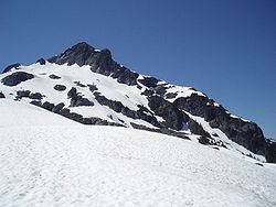
Golden Ears is the name of the summit that lies north of Maple Ridge
, British Columbia
and is visible from most of Metro Vancouver. The mountain is in Golden Ears Provincial Park
, and was originally referred to as Golden Eyries, possibly for Golden Eagles that were observed near the summit. There is much confusion about the name, however, because of the twin summits the peak exhibits many people believe the mountain is named because they look like ears which become golden in the sunset light.
 The area encompassing Golden Ears, Edge Peak
and Blanshard Peak
(Blanshard Needle) was originally called The Golden Eyries, and the name was corrupted to Golden Ears. The similarity of the 1716 m (5,630 ft) peak with the double summit to ears led people to believe that this mountain had the name Golden Ears. In the 1930s or 1940s the government of the day renamed the entire area to Mount Blanshard, and gave Edge Peak
its name, named the southernmost summit Blanshard Peak
, and conferred the official name Golden Ears to the 1716 m (5,630 ft) peak with the twin summit.
Current editions of the NTC
map 92G/07 and 92G/08 have the label Mount Blanchard since the Golden Ears group lies on the border between these two maps.
People in Metro Vancouver now refer to the area, the park and the peak as Golden Ears.

Maple Ridge, British Columbia
Maple Ridge is a District Municipality in British Columbia, located in the northeastern section of Metro Vancouver. Maple Ridge has a population of approximately 68,949.-History:...
, British Columbia
British Columbia
British Columbia is the westernmost of Canada's provinces and is known for its natural beauty, as reflected in its Latin motto, Splendor sine occasu . Its name was chosen by Queen Victoria in 1858...
and is visible from most of Metro Vancouver. The mountain is in Golden Ears Provincial Park
Golden Ears Provincial Park
Golden Ears Provincial Park is a Provincial Park in British Columbia, Canada at 555.9 km². It is named after the prominent twin peaks which are commonly referred to as Golden Ears...
, and was originally referred to as Golden Eyries, possibly for Golden Eagles that were observed near the summit. There is much confusion about the name, however, because of the twin summits the peak exhibits many people believe the mountain is named because they look like ears which become golden in the sunset light.

Edge Peak
Edge Peak is a summit in the Golden Ears Group, located in Golden Ears Provincial Park north of Maple Ridge, British Columbia. The peak is not named for its shape but rather for Sam Edge who climbed it in 1876...
and Blanshard Peak
Blanshard Peak
Blanshard Peak also known as The Blanshard Needle by local climbers is a distinctive rock pinnacle in Golden Ears Provincial Park that is visible from many places in the Lower Mainland...
(Blanshard Needle) was originally called The Golden Eyries, and the name was corrupted to Golden Ears. The similarity of the 1716 m (5,630 ft) peak with the double summit to ears led people to believe that this mountain had the name Golden Ears. In the 1930s or 1940s the government of the day renamed the entire area to Mount Blanshard, and gave Edge Peak
Edge Peak
Edge Peak is a summit in the Golden Ears Group, located in Golden Ears Provincial Park north of Maple Ridge, British Columbia. The peak is not named for its shape but rather for Sam Edge who climbed it in 1876...
its name, named the southernmost summit Blanshard Peak
Blanshard Peak
Blanshard Peak also known as The Blanshard Needle by local climbers is a distinctive rock pinnacle in Golden Ears Provincial Park that is visible from many places in the Lower Mainland...
, and conferred the official name Golden Ears to the 1716 m (5,630 ft) peak with the twin summit.
Current editions of the NTC
National Topographic System
The National Topographic System or NTS is the topographic system used by Canada for providing general purpose maps of the country. NTS maps are available in 1/50,000 and 1/250,000 scales. The maps provide details on landforms and terrain, lakes and rivers, forested areas, administrative zones,...
map 92G/07 and 92G/08 have the label Mount Blanchard since the Golden Ears group lies on the border between these two maps.
People in Metro Vancouver now refer to the area, the park and the peak as Golden Ears.
See also
- Golden Ears GroupGolden Ears GroupThe Golden Ears is the name of a group of mountains in the southern portion of Golden Ears Provincial Park, and visible to most of the Lower Mainland of British Columbia. It is a part of the Garibaldi Ranges, and is located in Golden Ears Provincial Park....
- Golden Ears Provincial ParkGolden Ears Provincial ParkGolden Ears Provincial Park is a Provincial Park in British Columbia, Canada at 555.9 km². It is named after the prominent twin peaks which are commonly referred to as Golden Ears...


