Government Cut
Encyclopedia


Miami Beach, Florida
Miami Beach is a coastal resort city in Miami-Dade County, Florida, United States, incorporated on March 26, 1915. The municipality is located on a barrier island between the Atlantic Ocean and Biscayne Bay, the latter which separates the Beach from Miami city proper...
and Fisher Island
Fisher Island, Florida
Fisher Island is a neighborhood of metropolitan Miami, Florida, located on a barrier island of the same name. As of the 2000 census, Fisher Island had the highest per capita income of any place in the United States in 2000. The CDP had only 218 households and a total population of 467 persons...
, which allows better access to the Port of Miami
Port of Miami
The Dante B. Fascell Port of Miami is a seaport located in Biscayne Bay in Miami, Florida, United States. It is connected to Downtown Miami by Port Boulevard, a bridge over the Intracoastal Waterway. The port is located on Dodge Island, which is the combination of three historic islands that have...
in Miami, Florida
Florida
Florida is a state in the southeastern United States, located on the nation's Atlantic and Gulf coasts. It is bordered to the west by the Gulf of Mexico, to the north by Alabama and Georgia and to the east by the Atlantic Ocean. With a population of 18,801,310 as measured by the 2010 census, it...
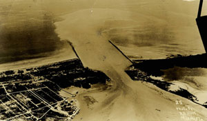
. Before the cut was established, a single peninsula of dry land stretched from what is now Miami Beach to what is now Fisher Island, and boats destined for the port at the mouth of the Miami River
Miami River (Florida)
The Miami River is a river in the United States state of Florida that drains out of the Everglades and runs through the Downtown and the city of Miami. The long river flows from the terminus of the Miami Canal at Miami International Airport to Biscayne Bay...
had to pass around Cape Florida, to the south of Key Biscayne.
Opened in 1905, the cut across the peninsula that is now Miami Beach
Miami Beach, Florida
Miami Beach is a coastal resort city in Miami-Dade County, Florida, United States, incorporated on March 26, 1915. The municipality is located on a barrier island between the Atlantic Ocean and Biscayne Bay, the latter which separates the Beach from Miami city proper...
was authorized by the U.S. Government (hence the name), in order to provide a direct route
Thoroughfare
A thoroughfare is a place of transportation intended to connect one location to another. Highways, roads, and trails are examples of thoroughfares used by a variety of general traffic. On land a thoroughfare may refer to anything from a rough trail to multi-lane highway with grade separated...
from the Atlantic Ocean
Atlantic Ocean
The Atlantic Ocean is the second-largest of the world's oceanic divisions. With a total area of about , it covers approximately 20% of the Earth's surface and about 26% of its water surface area...
on the east to the seaport on Biscayne Bay
Biscayne Bay
Biscayne Bay is a lagoon that is approximately 35 miles long and up to 8 miles wide located on the Atlantic coast of South Florida, United States. It is usually divided for purposes of discussion and analysis into three parts: North Bay, Central Bay, and South Bay. Its area is...
to the west, without having to detour
Detour (road)
A detour or diversion route is a route around a planned area of prohibited or reduced access, such as a construction site.Standard operating procedure for many road departments is to route any detour over roads within the same jurisdiction as the road with the obstructed area.On multi-lane highways...
southward. The cut across the mangrove
Mangrove
Mangroves are various kinds of trees up to medium height and shrubs that grow in saline coastal sediment habitats in the tropics and subtropics – mainly between latitudes N and S...
s and beach at the southern end of the peninsula created Fisher Island, which except for the extreme northeast corner, is part of unincorporated Miami-Dade County, Florida. The now-famous South Beach
South Beach
South Beach, also nicknamed SoBe, is a neighborhood in the city of Miami Beach, Florida, United States. It is the area south of Indian Creek and encompasses roughly the southernmost 23 blocks of the main barrier island that separates the Atlantic Ocean and Biscayne Bay.This area was the first...
is to the north of the cut.
Establishment
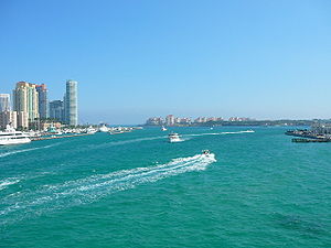
Government Cut was authorized by the U.S. Congress in 1902, after the Committee on Rivers and Harbors of the U.S. House of Representatives approved it on June 13 of that year. Dredging began in 1903, and finished in the summer of 1905. FillFill dirt
Fill dirt is earthy material which is used to fill in a depression or hole in the ground or create mounds or otherwise artificially change the grade or elevation of real property....
from the dreging was used to add to the privately-owned Fisher Island. Later dredging to widen and deepen the cut also added land area to the Port of Miami, and created the foundation
Foundation (architecture)
A foundation is the lowest and supporting layer of a structure. Foundations are generally divided into two categories: shallow foundations and deep foundations.-Shallow foundations:...
for the MacArthur Causeway
MacArthur Causeway
The General Douglas MacArthur Causeway is a six-lane causeway which connects Downtown, Miami, Florida and South Beach, Miami Beach via Biscayne Bay....
(east of Interstate 395
Interstate 395 (Florida)
Interstate 395 is a long, elevated Interstate Highway that connects Interstate 95 in the west with the MacArthur Causeway in the east in the Miami area via the Midtown Interchange...
).
Operation
Operation of the cut falls upon three government agencies. The Port of Miami is responsibleMoral responsibility
Moral responsibility usually refers to the idea that a person has moral obligations in certain situations. Disobeying moral obligations, then, becomes grounds for justified punishment. Deciding what justifies punishment, if anything, is a principle concern of ethics.People who have moral...
for navigation
Navigation
Navigation is the process of monitoring and controlling the movement of a craft or vehicle from one place to another. It is also the term of art used for the specialized knowledge used by navigators to perform navigation tasks...
, while the United States Coast Guard
United States Coast Guard
The United States Coast Guard is a branch of the United States Armed Forces and one of the seven U.S. uniformed services. The Coast Guard is a maritime, military, multi-mission service unique among the military branches for having a maritime law enforcement mission and a federal regulatory agency...
is responsible for safety
Safety
Safety is the state of being "safe" , the condition of being protected against physical, social, spiritual, financial, political, emotional, occupational, psychological, educational or other types or consequences of failure, damage, error, accidents, harm or any other event which could be...
and security
Security
Security is the degree of protection against danger, damage, loss, and crime. Security as a form of protection are structures and processes that provide or improve security as a condition. The Institute for Security and Open Methodologies in the OSSTMM 3 defines security as "a form of protection...
, and the U.S. Army Corps of Engineers for the channel itself, including dredging.
Notoriety
Local oceanOcean
An ocean is a major body of saline water, and a principal component of the hydrosphere. Approximately 71% of the Earth's surface is covered by ocean, a continuous body of water that is customarily divided into several principal oceans and smaller seas.More than half of this area is over 3,000...
tide
Tide
Tides are the rise and fall of sea levels caused by the combined effects of the gravitational forces exerted by the moon and the sun and the rotation of the Earth....
s for Miami are reported for the entrance to Government Cut. The next-closest point on the mainland
Mainland
Mainland is a name given to a large landmass in a region , or to the largest of a group of islands in an archipelago. Sometimes its residents are called "Mainlanders"...
for tide information is Jupiter Inlet, to the north.
In December 2005, the vintage Grumman G-73 Mallard seaplane
Seaplane
A seaplane is a fixed-wing aircraft capable of taking off and landing on water. Seaplanes that can also take off and land on airfields are a subclass called amphibian aircraft...
providing Chalk's Ocean Airways Flight 101
Chalk's Ocean Airways flight 101
Chalk's Ocean Airways Flight 101 was an aircraft crash that occurred off Miami Beach, Florida, in the United States on December 19, 2005. All 20 passengers and crew on board the 1947 Grumman G-73T Turbine Mallard died in the crash, which was attributed to metal fatigue on the starboard wing...
crashed
Aviation accidents and incidents
An aviation accident is defined in the Convention on International Civil Aviation Annex 13 as an occurrence associated with the operation of an aircraft which takes place between the time any person boards the aircraft with the intention of flight and all such persons have disembarked, in which a...
immediately offshore Government Cut, temporarily closing the channel to all traffic and trapping freighters
Cargo ship
A cargo ship or freighter is any sort of ship or vessel that carries cargo, goods, and materials from one port to another. Thousands of cargo carriers ply the world's seas and oceans each year; they handle the bulk of international trade...
and cruise ship
Cruise ship
A cruise ship or cruise liner is a passenger ship used for pleasure voyages, where the voyage itself and the ship's amenities are part of the experience, as well as the different destinations along the way...
s on both sides.

