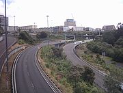
Grafton Gully
Encyclopedia


Gully
A gully is a landform created by running water, eroding sharply into soil, typically on a hillside. Gullies resemble large ditches or small valleys, but are metres to tens of metres in depth and width...
cutting northwards (towards the sea) through the volcanic hills of the Auckland Volcanic Field
Auckland Volcanic Field
The Auckland volcanic field is a monogenetic volcanic field in the North Island of New Zealand. Basaltic in nature, it underlies much of the metropolitan area of Auckland....
in Auckland
Auckland
The Auckland metropolitan area , in the North Island of New Zealand, is the largest and most populous urban area in the country with residents, percent of the country's population. Auckland also has the largest Polynesian population of any city in the world...
, New Zealand
New Zealand
New Zealand is an island country in the south-western Pacific Ocean comprising two main landmasses and numerous smaller islands. The country is situated some east of Australia across the Tasman Sea, and roughly south of the Pacific island nations of New Caledonia, Fiji, and Tonga...
. It divides the CBD
Central business district
A central business district is the commercial and often geographic heart of a city. In North America this part of a city is commonly referred to as "downtown" or "city center"...
of the city from the suburbs of Grafton
Grafton, New Zealand
Grafton is a suburb of Auckland City, New Zealand. The suburb is named for the Duke of Grafton, a patron of the first Governor of New Zealand, William Hobson, and was once known as 'Grafton Heights', denoting it's history as a well-off suburb in Auckland's earliest decades...
and Parnell
Parnell, New Zealand
Parnell is a suburb of Auckland, New Zealand. It is often billed as Auckland's "oldest suburb" since it dates from the earliest days of the European settlement of Auckland in 1841...
in the east.
Grafton Gully is crossed by Grafton Bridge
Grafton Bridge
Grafton Bridge is a road bridge spanning Grafton Gully in Auckland City, New Zealand. Built of reinforced concrete in 1910, it connects the Auckland CBD with the Grafton suburb...
near its south end. Symonds Street Cemetery
Symonds Street Cemetery
Symonds Street Cemetery is a historic cemetery and park in central Auckland, New Zealand. It is in 5.8 hectares of deciduous forest on the western slope of Grafton Gully, by the corner of Symonds Street and Karangahape Road, and is crossed by the Grafton Bridge...
lies on its western slope.
Usage
The gully is of the few areas in Auckland proper which has not been claimed by either buildings nor for recreation (mostly due to the steepness of its sides), though prior to the construction of the motorway, part of the gully was occupied by the Blandford ParkBlandford Park
Blandford Park, in Auckland, New Zealand, was the home of association football in Auckland for much of the 20th century, and one of the country's main football grounds...
sports facility until the mid 1960s.
Large extents of the gully are still mostly covered with bush, though the bottom of the gully carries multiple motorway lanes of the State Highways 1, 16 and 16A into the city further north (such as to Ports of Auckland
Ports of Auckland
Ports of Auckland Limited , the successor to the Auckland Harbour Board, is the company administering Auckland's commercial freight and cruise ship harbour facilities...
). SH16 (Stanley Street) carried an average of 34,000 vehicles per day in 2003.
The Grafton Gully motorway project included two stages (with a third planned for when future traffic reaches trigger levels) and was built for NZ$ 68 million during 2001-2003.
It is hoped that by 2012, the Northwestern Cycleway
Northwestern Cycleway
The Northwestern Cycleway is a 12 km mostly off-road cycle route connecting the Auckland CBD in Auckland City with Henderson, Waitakere City in New Zealand...
could be extended through the gully, as far as the University of Auckland
University of Auckland
The University of Auckland is a university located in Auckland, New Zealand. It is the largest university in the country and the highest ranked in the 2011 QS World University Rankings, having been ranked worldwide...
campus areas in the eastern Auckland CBD
Auckland CBD
The Auckland CBD is the geographical and economic heart of the Auckland metropolitan area. Bounded by several major motorways and by the harbour coastline in the north, it is surrounded further out by mostly suburban areas...
.

