
Grampians National Park
Encyclopedia
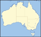
The Grampians National Park (also Gariwerd) is a national park
in Victoria
, Australia
, 235 kilometres west of Melbourne. The Park was listed on the Australian National Heritage List
on 15 December 2006 for its outstanding natural beauty and being one of the richest indigenous rock art sites in south-eastern Australia.
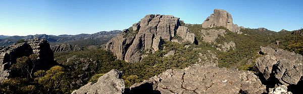
The Grampians feature a striking series of sandstone
mountain range
s. The ranges were named in 1836 by Surveyor General of New South Wales
Sir Thomas Mitchell after the Grampian Mountains in his native Scotland
, but are also known by the name Gariwerd, from one of the local Australian Aboriginal languages
, either the Jardwadjali
or Djab Wurrung
language. After a two-year consultation process, the park was renamed Grampians (Gariwerd) National Park in 1991, however this controversial formality was reversed after a change of state government in 1992. The Geographic Place Names Act 1998 reinstated dual naming for geographical features, and this has been subsequently adopted in the Park based on Jardwadjali and Djab Wurrung names for rock art sites and landscape features with the National Heritage List referring to Grampians National Park (Gariwerd).
 This area is a distinct physiographic section of the larger Western Victorian Highlands province, which in turn is part of the larger East Australian Cordillera physiographic division.
In spring the Grampians wildflowers are a major attraction. The area is a noted rock climbing
destination, and it is popular with campers and bushwalkers for its many spectacular views and unspoilt nature. However this may be under increasing threat from increasing development of the area.
Mount William is known within the gliding community as the epicentre of the 'Grampians Wave', a weather phenomenon enabling glider pilots to reach extreme altitudes above 28000 ft (8,534.4 m). This predominantly occurs during the months of May, June, September and October when strong westerly winds flow at right angles to the ridge, and produce a large-scale standing wave (Mountain Lee Wave).
era 380 million years ago. This sediment slowly accumulated to a depth of 7 km; this was later raised and tilted for its present form. Forty million years ago the Southern Ocean
reached the base of the northern and western base of the mountain range, the deposition from the range forming the sea floor which is now Little Desert National Park
.
The highest peak is Mount William
at 1167 metres. Numerous waterfalls are found in the park and are easily accessible via a well-developed road network.
and Djab wurrung
peoples Gariwerd was central to the dreaming of the creator, Bunjil
, and buledji Brambimbula, the two brothers Bram, who were responsible for the creation and naming of many landscape features in western Victoria.
Grampians National Park (Gariwerd) is one of the richest Indigenous rock art sites in south-eastern Australia and was listed on the National Heritage for its natural beauty and its past and continuing aboriginal cultural associations. Motifs painted in numerous caves include depictions of humans, human hands, animal tracks and birds. Notable rock art sites include:
The rock art was created by Jardwadjali
and Djab Wurrung
peoples, and while Aboriginal communities continue to pass on knowledge and cultural traditions, much indigenous knowledge has also been lost since European settlement of the area from 1840. The significance of the right hand prints at Gulgurn Manja is now unknown.
Dual naming of features has been adopted in the Park based on Jardwadjali and Djab Wurrung names for rock art sites and landscape features, including:
/ Budja Budja is the largest service town in the area and is located at a point roughly equidistant between the towns of Ararat and Stawell
. The town is located towards the eastern side of the park and offers accommodation to the many tourists who visit the area.
The Brambuk National Park and Cultural Centre in Halls Gap
is owned and managed by Jardwadjali
and Djab Wurrung
people from five Aboriginal communities with historic links to the Gariwerd-Grampians ranges and the surrounding plains.
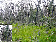 A major bushfire
burned out about 50 per cent of the Grampians National Park in January 2006. Major flooding
followed 5 years later in January 2011, forcing the closure of some parts of the Grampians National Park for several months, and an 3.8 earthquake followed 6 months after that, although it failed to create any damage. Soon after the 2006 bushfire, the first signs of regeneration were already visible, with regrowth of the eucalyptus
trees is quite typical. Many trees re-sprout with a mass of young shoots along the whole length of the trunk to the base of the tree - called epicormic growth.
The Grampians National Park was featured on The Mole
; the assignment in that show was that the contestants had to search and rescue two of their teammates. This assignment was failed and Hal Pritchard and Shane Jolley couldn't be found in time, therefore they had to spend a night out in the dark at the park.
National park
A national park is a reserve of natural, semi-natural, or developed land that a sovereign state declares or owns. Although individual nations designate their own national parks differently A national park is a reserve of natural, semi-natural, or developed land that a sovereign state declares or...
in Victoria
Victoria (Australia)
Victoria is the second most populous state in Australia. Geographically the smallest mainland state, Victoria is bordered by New South Wales, South Australia, and Tasmania on Boundary Islet to the north, west and south respectively....
, Australia
Australia
Australia , officially the Commonwealth of Australia, is a country in the Southern Hemisphere comprising the mainland of the Australian continent, the island of Tasmania, and numerous smaller islands in the Indian and Pacific Oceans. It is the world's sixth-largest country by total area...
, 235 kilometres west of Melbourne. The Park was listed on the Australian National Heritage List
Australian National Heritage List
The Australian National Heritage List is a list of places deemed to be of outstanding heritage significance to Australia. The list includes natural, historic and indigenous places...
on 15 December 2006 for its outstanding natural beauty and being one of the richest indigenous rock art sites in south-eastern Australia.
The Grampians feature a striking series of sandstone
Sandstone
Sandstone is a sedimentary rock composed mainly of sand-sized minerals or rock grains.Most sandstone is composed of quartz and/or feldspar because these are the most common minerals in the Earth's crust. Like sand, sandstone may be any colour, but the most common colours are tan, brown, yellow,...
mountain range
Mountain range
A mountain range is a single, large mass consisting of a succession of mountains or narrowly spaced mountain ridges, with or without peaks, closely related in position, direction, formation, and age; a component part of a mountain system or of a mountain chain...
s. The ranges were named in 1836 by Surveyor General of New South Wales
Surveyor General of New South Wales
The Surveyor General of New South Wales is the person nominally responsible for government surveying in New South Wales. The original duties for the Surveyor General was to measure and determine land grants for settlers in New South Wales...
Sir Thomas Mitchell after the Grampian Mountains in his native Scotland
Scotland
Scotland is a country that is part of the United Kingdom. Occupying the northern third of the island of Great Britain, it shares a border with England to the south and is bounded by the North Sea to the east, the Atlantic Ocean to the north and west, and the North Channel and Irish Sea to the...
, but are also known by the name Gariwerd, from one of the local Australian Aboriginal languages
Australian Aboriginal languages
The Australian Aboriginal languages comprise several language families and isolates native to the Australian Aborigines of Australia and a few nearby islands, but by convention excluding the languages of Tasmania and the Torres Strait Islanders...
, either the Jardwadjali
Jardwadjali
The Jardwadjali people are Indigenous Australians who occupy the lands in the upper Wimmera River watershed east to Gariwerd and west to Lake Bringalbert. The towns of Horsham, Cavendish, Coleraine, Asply, Minyip and Donald are within their territory...
or Djab Wurrung
Djab Wurrung
The Djab wurrung people are Indigenous Australians who occupy the volcanic plains of central Victoria from the Mount William Range of Gariwerd in the west to the Pyrenees range in the east encompassing the Wimmera River flowing north and the headwaters of the Hopkins River flowing south. The towns...
language. After a two-year consultation process, the park was renamed Grampians (Gariwerd) National Park in 1991, however this controversial formality was reversed after a change of state government in 1992. The Geographic Place Names Act 1998 reinstated dual naming for geographical features, and this has been subsequently adopted in the Park based on Jardwadjali and Djab Wurrung names for rock art sites and landscape features with the National Heritage List referring to Grampians National Park (Gariwerd).
Physiography
Geography
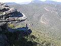
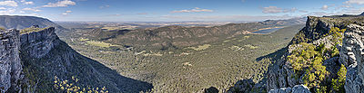
The general form that the ranges take is, from the west, a series of low-angled sandstone ridges running roughly north-south. The eastern sides of the ridges, where the sedimentary layers have faulted, are steep and spectacular, beyond the vertical in places - notably at Hollow Mountain near Dadswell's Bridge at the northern end of the ranges. The most popular walking area for day trippers is the Wonderland area near Halls Gap. In summer the ranges can get very hot and dry. Winter and spring are the best times for walking. The Wonderland area is also host to "The Grand Canyon" on the "Wonderland Loop" on one of the tracks to the "Pinnacle".In spring the Grampians wildflowers are a major attraction. The area is a noted rock climbing
Rock climbing
Rock climbing also lightly called 'The Gravity Game', is a sport in which participants climb up, down or across natural rock formations or artificial rock walls. The goal is to reach the summit of a formation or the endpoint of a pre-defined route without falling...
destination, and it is popular with campers and bushwalkers for its many spectacular views and unspoilt nature. However this may be under increasing threat from increasing development of the area.
Mount William is known within the gliding community as the epicentre of the 'Grampians Wave', a weather phenomenon enabling glider pilots to reach extreme altitudes above 28000 ft (8,534.4 m). This predominantly occurs during the months of May, June, September and October when strong westerly winds flow at right angles to the ridge, and produce a large-scale standing wave (Mountain Lee Wave).
Geology
The rock material that composes the high peaks is sandstone which was laid down from rivers during the DevonianDevonian
The Devonian is a geologic period and system of the Paleozoic Era spanning from the end of the Silurian Period, about 416.0 ± 2.8 Mya , to the beginning of the Carboniferous Period, about 359.2 ± 2.5 Mya...
era 380 million years ago. This sediment slowly accumulated to a depth of 7 km; this was later raised and tilted for its present form. Forty million years ago the Southern Ocean
Southern Ocean
The Southern Ocean comprises the southernmost waters of the World Ocean, generally taken to be south of 60°S latitude and encircling Antarctica. It is usually regarded as the fourth-largest of the five principal oceanic divisions...
reached the base of the northern and western base of the mountain range, the deposition from the range forming the sea floor which is now Little Desert National Park
Little Desert National Park
The Little Desert National Park is in Victoria, Australia, 375 kilometres west of Melbourne. It extends from the Wimmera River in the east to near Naracoorte over the South Australian border in the west.-History:...
.
The highest peak is Mount William
Mount William (Victoria)
Mount William is located within the Grampians National Park, approximately 250 kilometres west-north-west of Melbourne. It is situated on the eastern edge of the national park, approximately 22 kilometres drive from Halls Gap....
at 1167 metres. Numerous waterfalls are found in the park and are easily accessible via a well-developed road network.
Cultural heritage
To the JardwadjaliJardwadjali
The Jardwadjali people are Indigenous Australians who occupy the lands in the upper Wimmera River watershed east to Gariwerd and west to Lake Bringalbert. The towns of Horsham, Cavendish, Coleraine, Asply, Minyip and Donald are within their territory...
and Djab wurrung
Djab Wurrung
The Djab wurrung people are Indigenous Australians who occupy the volcanic plains of central Victoria from the Mount William Range of Gariwerd in the west to the Pyrenees range in the east encompassing the Wimmera River flowing north and the headwaters of the Hopkins River flowing south. The towns...
peoples Gariwerd was central to the dreaming of the creator, Bunjil
Bunjil
In Australian Aboriginal mythology, Bunjil the eagle is a creator deity, culture hero and ancestral being. In the Kulin nation in central Victoria he was regarded as one of two moiety ancestors, the other being the trickster Crow. Bunjil has two wives and a son, Binbeal the rainbow. His brother...
, and buledji Brambimbula, the two brothers Bram, who were responsible for the creation and naming of many landscape features in western Victoria.
Grampians National Park (Gariwerd) is one of the richest Indigenous rock art sites in south-eastern Australia and was listed on the National Heritage for its natural beauty and its past and continuing aboriginal cultural associations. Motifs painted in numerous caves include depictions of humans, human hands, animal tracks and birds. Notable rock art sites include:
- Billimina (Glenisla shelter)
- Jananginj Njani (Camp of the Emu's Foot)
- Manja (Cave of Hands)
- Larngibunja (Cave of Fishes)
- Ngamadjidj (Cave of Ghosts)
- Gulgurn Manja (Flat Rock).
The rock art was created by Jardwadjali
Jardwadjali
The Jardwadjali people are Indigenous Australians who occupy the lands in the upper Wimmera River watershed east to Gariwerd and west to Lake Bringalbert. The towns of Horsham, Cavendish, Coleraine, Asply, Minyip and Donald are within their territory...
and Djab Wurrung
Djab Wurrung
The Djab wurrung people are Indigenous Australians who occupy the volcanic plains of central Victoria from the Mount William Range of Gariwerd in the west to the Pyrenees range in the east encompassing the Wimmera River flowing north and the headwaters of the Hopkins River flowing south. The towns...
peoples, and while Aboriginal communities continue to pass on knowledge and cultural traditions, much indigenous knowledge has also been lost since European settlement of the area from 1840. The significance of the right hand prints at Gulgurn Manja is now unknown.
Dual naming of features has been adopted in the Park based on Jardwadjali and Djab Wurrung names for rock art sites and landscape features, including:
- Grampians / Gariwerd (mountain range)
- Mount Zero / Mura Mura (little hill)
- Halls Gap / Budja Budja
Tourism
Halls GapHalls Gap, Victoria
Halls Gap is a town in Victoria, Australia. It is located on Grampians Road, adjacent to the Grampians National Park, in the Shire of Northern Grampians local government area. The town is set in the Fyans Valley at the foot of the of Wonderland and Mount William ranges . At the 2006 census Halls...
/ Budja Budja is the largest service town in the area and is located at a point roughly equidistant between the towns of Ararat and Stawell
Stawell, Victoria
Stawell , is a town in the Wimmera region of Victoria, Australia. The town is located in Shire of Northern Grampians Local Government Area, west-north-west of the state capital, Melbourne. At the 2006 census, Stawell had a population of 6,035....
. The town is located towards the eastern side of the park and offers accommodation to the many tourists who visit the area.
The Brambuk National Park and Cultural Centre in Halls Gap
Halls Gap, Victoria
Halls Gap is a town in Victoria, Australia. It is located on Grampians Road, adjacent to the Grampians National Park, in the Shire of Northern Grampians local government area. The town is set in the Fyans Valley at the foot of the of Wonderland and Mount William ranges . At the 2006 census Halls...
is owned and managed by Jardwadjali
Jardwadjali
The Jardwadjali people are Indigenous Australians who occupy the lands in the upper Wimmera River watershed east to Gariwerd and west to Lake Bringalbert. The towns of Horsham, Cavendish, Coleraine, Asply, Minyip and Donald are within their territory...
and Djab Wurrung
Djab Wurrung
The Djab wurrung people are Indigenous Australians who occupy the volcanic plains of central Victoria from the Mount William Range of Gariwerd in the west to the Pyrenees range in the east encompassing the Wimmera River flowing north and the headwaters of the Hopkins River flowing south. The towns...
people from five Aboriginal communities with historic links to the Gariwerd-Grampians ranges and the surrounding plains.
History
Mount Lubra bushfire
The Mount Lubra bushfire was started by a lightning strike in January 2006 near The Grampians in Australia. The fire began late on the 19th of January, 2006. By the time it was extinguished it had burned for approximately two weeks and covered approximately 130,000 hectares of land.The fire burned...
burned out about 50 per cent of the Grampians National Park in January 2006. Major flooding
2011 Victorian floods
High intensity rainfall between 12–14 January 2011 caused major flooding across much of the western and central parts of the Australian state of Victoria...
followed 5 years later in January 2011, forcing the closure of some parts of the Grampians National Park for several months, and an 3.8 earthquake followed 6 months after that, although it failed to create any damage. Soon after the 2006 bushfire, the first signs of regeneration were already visible, with regrowth of the eucalyptus
Eucalyptus
Eucalyptus is a diverse genus of flowering trees in the myrtle family, Myrtaceae. Members of the genus dominate the tree flora of Australia...
trees is quite typical. Many trees re-sprout with a mass of young shoots along the whole length of the trunk to the base of the tree - called epicormic growth.
The Grampians National Park was featured on The Mole
The Mole (Australia season 2)
The second season of the Australian version of The Mole originally aired from 21 February 2001 to 25 April 2001. It took place in Victoria and was hosted by Grant Bowler.-Show Details:...
; the assignment in that show was that the contestants had to search and rescue two of their teammates. This assignment was failed and Hal Pritchard and Shane Jolley couldn't be found in time, therefore they had to spend a night out in the dark at the park.