Granville, Indiana
Encyclopedia

Wayne Township, Tippecanoe County, Indiana
Wayne Township is one of thirteen townships in Tippecanoe County, Indiana, USA. As of the 2000 census, its population was 1,306.-Geography:According to the United States Census Bureau, Wayne Township covers an area of ; of this, or 1.02 percent is water....
, Tippecanoe County
Tippecanoe County, Indiana
Tippecanoe County is a county located in the northwest quadrant of the U.S. state of Indiana. It was created in 1826 from Wabash County. It is part of the Lafayette, Indiana, Metropolitan Statistical Area....
, Indiana
Indiana
Indiana is a US state, admitted to the United States as the 19th on December 11, 1816. It is located in the Midwestern United States and Great Lakes Region. With 6,483,802 residents, the state is ranked 15th in population and 16th in population density. Indiana is ranked 38th in land area and is...
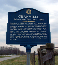
. It was founded in 1834 by Thomas W. Treckett and Thomas Concannon on the south side of the Wabash and Erie Canal
Wabash and Erie Canal
The Wabash and Erie Canal was a shipping canal that linked the Great Lakes to the Ohio River via an artificial waterway. The canal provided traders with access from the Great Lakes all the way to the Gulf of Mexico...
, just south of the Wabash River
Wabash River
The Wabash River is a river in the Midwestern United States that flows southwest from northwest Ohio near Fort Recovery across northern Indiana to southern Illinois, where it forms the Illinois-Indiana border before draining into the Ohio River, of which it is the largest northern tributary...
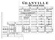
. The town was platted
Plat
A plat in the U.S. is a map, drawn to scale, showing the divisions of a piece of land. Other English-speaking countries generally call such documents a cadastral map or plan....
to contain 153 lots, a public square and several streets, with such names as Lafayette, Cherry, Wabash and Washington. This plat is still in effect, with the lots and streets still visible in the county's GIS http://gis.tippecanoe.in.gov/public/.
In 1850 the town's name changed to Weaton, after the local Wea
Wea
The Wea were a Miami-Illinois-speaking tribe originally located in western Indiana, closely related to the Miami. The name Wea is used today as the a shortened version of their many recorded names...
Indians (some maps incorrectly labeled it as "Wheaton"), but the name later reverted again to Granville. The town flourished as a shipping center on the canal until the mid 1850s, when railroad competition caused both the town and the canal to decline. By 1878 Granville had virtually ceased to exist.
The cemetery east of the town and the nearby bridge across the Wabash River still bear the name of Granville.

Geography
Granville is located at 40°24'25" North, 87°01'53" West (40.406944, -87.031389) in Wayne TownshipWayne Township, Tippecanoe County, Indiana
Wayne Township is one of thirteen townships in Tippecanoe County, Indiana, USA. As of the 2000 census, its population was 1,306.-Geography:According to the United States Census Bureau, Wayne Township covers an area of ; of this, or 1.02 percent is water....
, and has an elevation of approximately 550 feet.

