Grassy Cove
Encyclopedia

Cove (Appalachian Mountains)
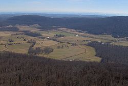
In the central and southern Appalachian Mountains of Eastern North America, a cove is a small valley between two ridge lines that is closed at one or both ends....
in Cumberland County, Tennessee, in the southeastern United States. The valley is notable for its karst
KARST
Kilometer-square Area Radio Synthesis Telescope is a Chinese telescope project to which FAST is a forerunner. KARST is a set of large spherical reflectors on karst landforms, which are bowlshaped limestone sinkholes named after the Kras region in Slovenia and Northern Italy. It will consist of...
formations, which have been designated a National Natural Landmark
National Natural Landmark
The National Natural Landmark program recognizes and encourages the conservation of outstanding examples of the natural history of the United States. It is the only natural areas program of national scope that identifies and recognizes the best examples of biological and geological features in...
. Grassy Cove is also home to a small unincorporated community.
Grassy Cove is located atop the Cumberland Plateau
Cumberland Plateau
The Cumberland Plateau is the southern part of the Appalachian Plateau. It includes much of eastern Kentucky and western West Virginia, part of Tennessee, and a small portion of northern Alabama and northwest Georgia . The terms "Allegheny Plateau" and the "Cumberland Plateau" both refer to the...
approximately 5 miles (8 km) east of Crossville
Crossville, Tennessee
Crossville is a city in and the county seat of Cumberland County, Tennessee, United States. The population was 10,795 at the 2010 Census.-Geography:Crossville is located at...
and 5 miles (8 km) west of the plateau's Walden Ridge
Walden Ridge
Walden Ridge is a mountain ridge and escarpment located in Tennessee, in the United States. It marks the eastern edge of the Cumberland Plateau and is generally considered part of it. Walden Ridge is about long, running generally north-south...
escarpment. The mountains that surround the cove are part of the southern fringe of the Cumberland Mountains
Cumberland Mountains
The Cumberland Mountains are a mountain range in the southeastern section of the Appalachian Mountains. They are located in southern West Virginia, western Virginia, eastern edges of Kentucky, and eastern middle Tennessee, including the Crab Orchard Mountains...
. The cove is geologically related to the Sequatchie Valley
Sequatchie Valley
Sequatchie Valley is a relatively long and narrow valley in the U.S. state of Tennessee and, in some definitions, Alabama. It is generally considered to be part of the Cumberland Plateau region of the Appalachian Mountains; it was probably formed by erosion of a compression anticline, rather than...
, a large narrow valley stretching just opposite the mountains to the south. Tennessee State Route 68 passes through the northern part of Grassy Cove, providing the valley's only major road access.
Geology

Both the Sequatchie Valley and Grassy Cove were part of an anticline
Anticline
In structural geology, an anticline is a fold that is convex up and has its oldest beds at its core. The term is not to be confused with antiform, which is a purely descriptive term for any fold that is convex up. Therefore if age relationships In structural geology, an anticline is a fold that is...
that formed as rock strata were bent upward by thrust faulting to form a large ridge during the Paleozoic era (appx. 250 million years ago). During the Mesozoic era, continued erosion along this ridge exposed its younger, more soluble limestone
Limestone
Limestone is a sedimentary rock composed largely of the minerals calcite and aragonite, which are different crystal forms of calcium carbonate . Many limestones are composed from skeletal fragments of marine organisms such as coral or foraminifera....
layers. Over subsequent millennia, the limestone dissolved, forming a series of sinkhole
Sinkhole
A sinkhole, also known as a sink, shake hole, swallow hole, swallet, doline or cenote, is a natural depression or hole in the Earth's surface caused by karst processes — the chemical dissolution of carbonate rocks or suffosion processes for example in sandstone...
s that eventually coalesced to create the Sequatchie Valley. Grassy Cove is one such sinkhole that has yet to coalesce with the rest of the Sequatchie Valley.
Grassy Cove is drained entirely by underground streams. The valley's main stream, Grassy Cove Creek, flows northward across the cove before dropping into Mill Cave on the slopes of Brady Mountain. It then winds its way southward through a series of caves before reemerging in the Sequatchie Valley to the south, where it forms the headwaters of the Sequatchie River
Sequatchie River
The Sequatchie River is a waterway that drains the Sequatchie Valley, a large valley in the Cumberland Plateau in Middle Tennessee.-Hydrography:The Sequatchie River's source is a massive spring which flows out of Head of Sequatchie Spring...
. Grassy Cove Saltpeter Cave, located on the eastern slope of Brady Mountain, is the eleventh-longest cave in Tennessee and one of the 100 longest caves in the United States. Other caves in the cove include Windlass Cave, Bristow Cave, Mill Cave, and Milksick Cave.
History

Native Americans in the United States
Native Americans in the United States are the indigenous peoples in North America within the boundaries of the present-day continental United States, parts of Alaska, and the island state of Hawaii. They are composed of numerous, distinct tribes, states, and ethnic groups, many of which survive as...
were living in the cove during prehistoric times. Also, early 19th-century settlers reportedly found the cove bottom cleared and containing only high grass upon their arrival.
The first Euro-American settlers arrived in Grassy Cove in 1801. This early caravan consisted primarily of families from Fluvanna County, Virginia
Fluvanna County, Virginia
As of 2002, Fluvanna County's population was 20,047. There are 7,387 households, and 5,702 families residing in the county. The population density was 70 people per square mile . There were 8,018 housing units at an average density of 28 per square mile...
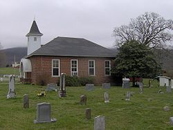
. In 1803, they completed a log church and formed the Grassy Cove United Methodist Church, one of the first congregations in the Cumberland Plateau region. Prominent early settlers included John Ford, the community's founder, Conrad Kemmer, a Revolutionary War
American Revolutionary War
The American Revolutionary War , the American War of Independence, or simply the Revolutionary War, began as a war between the Kingdom of Great Britain and thirteen British colonies in North America, and ended in a global war between several European great powers.The war was the result of the...
veteran who arrived in 1808, and Weatherston Greer, who arrived around 1830. Greer set up the first post office in the cove, operated a sawmill and gristmill, and owned large tracts of land in the cove until the American Civil War
American Civil War
The American Civil War was a civil war fought in the United States of America. In response to the election of Abraham Lincoln as President of the United States, 11 southern slave states declared their secession from the United States and formed the Confederate States of America ; the other 25...
. Kemmer's descendants own much of the land in Grassy Cove today.
During the American Civil War
American Civil War
The American Civil War was a civil war fought in the United States of America. In response to the election of Abraham Lincoln as President of the United States, 11 southern slave states declared their secession from the United States and formed the Confederate States of America ; the other 25...
(1861-1865), Grassy Cove's caves were an invaluable source of saltpeter
Potassium nitrate
Potassium nitrate is a chemical compound with the formula KNO3. It is an ionic salt of potassium ions K+ and nitrate ions NO3−.It occurs as a mineral niter and is a natural solid source of nitrogen. Its common names include saltpetre , from medieval Latin sal petræ: "stone salt" or possibly "Salt...
, which was used in the manufacture of gunpowder. According to a local legend, the body of a Confederate
Confederate States of America
The Confederate States of America was a government set up from 1861 to 1865 by 11 Southern slave states of the United States of America that had declared their secession from the U.S...
soldier (in full uniform) was found in a petrified state in one of the caves shortly after the war. When no one claimed the body, it was buried in the Grassy Cove Methodist Cemetery. Several residents claimed to have seen the soldier's ghost in the church, however, and when church attendance began to drop as a result, the soldier's body was disinterred and reburied in an undisclosed location.
The Cumberland Trail
In 1998, the state of Tennessee established the Justin P. Wilson Cumberland Trail State Park, a linear park that will eventually encompass the 300 miles (482.8 km) Cumberland TrailCumberland Trail
The Cumberland Trail is a hiking trail following a line of ridges and gorges along the eastern escarpment of the Cumberland Plateau in Tennessee. The trail begins at Cumberland Gap National Historical Park and ends at Chickamauga and Chattanooga National Military Park and Prentice Cooper Wildlife...
(the trail is still currently under construction). The trail now includes the 15 miles (24.1 km) "Grassy Cove Segment" that traverses the crests of Black Mountain and Brady Mountain. This segment of the trail will connect the Crab Orchard Segment (still being planned) with the Stinging Fork segment (partially completed) to the south.
External links
- Grassy Cove Karst Area — National Park ServiceNational Park ServiceThe National Park Service is the U.S. federal agency that manages all national parks, many national monuments, and other conservation and historical properties with various title designations...
website - Tennessee sinkholes

