
Great Lakes census statistical areas
Encyclopedia
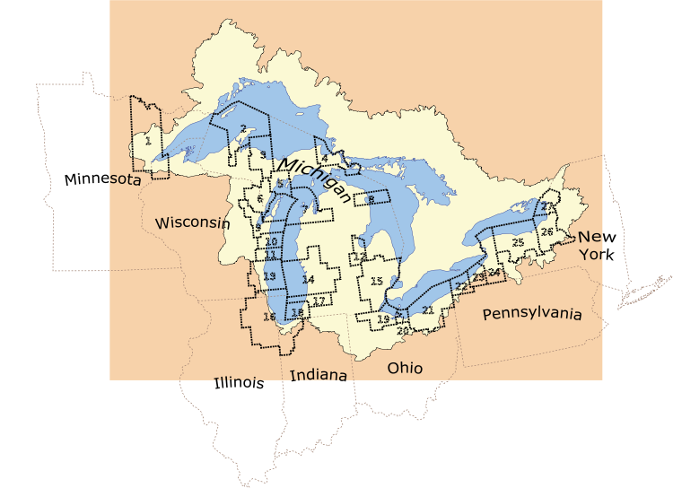
Along the Great Lakes
, there are 27 United States census statistical areas - 10 Combined Statistical Area
s, 7 Metropolitan Statistical Areas (independent of the Combined Statistical Areas), and 3 Micropolitan Statistical Areas (independent of the Combined Statistical Areas), as defined by the United States Census Bureau
.
The following four sortable tables list the 27 census statistical areas of the United States located on the Great Lakes, by lake, with the following information:
Great Lakes
The Great Lakes are a collection of freshwater lakes located in northeastern North America, on the Canada – United States border. Consisting of Lakes Superior, Michigan, Huron, Erie, and Ontario, they form the largest group of freshwater lakes on Earth by total surface, coming in second by volume...
, there are 27 United States census statistical areas - 10 Combined Statistical Area
Combined Statistical Area
The United States Office of Management and Budget defines micropolitan and metropolitan statistical areas. Metropolitan and micropolitan statistical areas consist of one or more counties...
s, 7 Metropolitan Statistical Areas (independent of the Combined Statistical Areas), and 3 Micropolitan Statistical Areas (independent of the Combined Statistical Areas), as defined by the United States Census Bureau
United States Census Bureau
The United States Census Bureau is the government agency that is responsible for the United States Census. It also gathers other national demographic and economic data...
.
Table
The following sortable table lists the 27 census statistical areas of the United States located on the Great Lakes with the following information:- The rank by population as of 2007-07-01, as estimated by the United States Census Bureau
- The census statistical area name as defined by the United States Census Bureau
- The census statistical area population as of 2007-07-01, as estimated by the United States Census Bureau
- Lakes within census statistical area
| Rank | Map Reference Number | Census Statistical Area | 2007 Population | Lake(s) |
|---|---|---|---|---|
| 1 | 16 | Chicago-Naperville-Michigan City, IL-IN-WI CSA | 9,745,165 | Lake Michigan |
| 2 | 15 | Detroit-Warren-Flint, MI CSA | 5,405,918 | Lake Erie and Lake Huron |
| 3 | 21 | Cleveland-Akron-Elyria, OH CSA | 2,896,968 | Lake Erie |
| 4 | 13 | Milwaukee-Racine-Waukesha, WI CSA | 1,739,497 | Lake Michigan |
| 5 | 14 | Grand Rapids-Muskegon-Holland, MI CSA | 1,323,095 | Lake Michigan |
| 6 | 24 | Buffalo-Niagara-Cattaraugus, NY CSA | 1,208,270 | Lake Erie and Lake Ontario |
| 7 | 25 | Rochester-Batavia-Seneca Falls, NY CSA | 1,122,845 | Lake Ontario |
| 8 | 26 | Syracuse-Auburn, NY CSA | 725,359 | Lake Ontario |
| 9 | 19 | Toledo-Fremont, OH CSA | 711,952 | Lake Erie |
| 10 | 17 | Kalamazoo-Portage, MI MSA | 323,264 | Lake Michigan |
| 11 | 12 | Saginaw-Bay City-Saginaw Township North, MI CSA | 309,785 | Lake Huron |
| 12 | 9 | Green Bay, WI MSA | 301,131 | Lake Michigan |
| 13 | 22 | Erie, PA MSA | 279,092 | Lake Erie |
| 14 | 1 | Duluth, MN-WI MSA | 274,308 | Lake Superior |
| 15 | 18 | Niles-Benton Harbor, MI MSA | 159,589 | Lake Michigan |
| 16 | 7 | Traverse City, MI μSA | 142,075 | Lake Michigan |
| 17 | 23 | Jamestown-Dunkirk-Fredonia, NY μSA | 133,945 | Lake Erie |
| 18 | 27 | Watertown-Fort Drum, NY μSA | 117,201 | Lake Ontario |
| 19 | 11 | Sheboygan, WI MSA | 114,504 | Lake Michigan |
| 20 | 10 | Manitowoc, WI μSA | 80,928 | Lake Michigan |
| 21 | 20 | Sandusky, OH MSA | 77,323 | Lake Erie |
| 22 | 6 | Marinette, WI-MI μSA | 66,820 | Lake Michigan |
| 23 | 3 | Marquette, MI μSA | 65,216 | Lake Superior |
| 24 | 4 | Sault Ste. Marie, MI μSA | 38,922 | Lake Huron and Lake Superior |
| 25 | 5 | Escanaba, MI μSA | 37,367 | Lake Michigan |
| 26 | 2 | Houghton, MI μSA | 37,352 | Lake Superior |
| 27 | 8 | Alpena, MI μSA | 29,707 | Lake Huron |
The following four sortable tables list the 27 census statistical areas of the United States located on the Great Lakes, by lake, with the following information:
- The rank by population as of 2007-07-01, as estimated by the United States Census Bureau
- The census statistical area name as defined by the United States Census Bureau
- The census statistical area population as of 2007-07-01, as estimated by the United States Census Bureau
- Comment
| Rank | Map Reference Number | Census Statistical Area | 2007 Population | Comment |
|---|---|---|---|---|
| 1 | 15 | Detroit-Warren-Flint, MI CSA | 5,405,918 | Also located on Lake Huron. |
| 2 | 12 | Cleveland-Akron-Elyria, OH CSA | 2,896,968 | |
| 3 | 24 | Buffalo-Niagara-Cattaraugus, NY CSA | 1,208,270 | Also located on Lake Ontario. |
| 4 | 19 | Toledo-Fremont, OH CSA | 711,952 | |
| 5 | 22 | Erie, PA MSA | 279,092 | |
| 6 | 23 | Jamestown-Dunkirk-Fredonia, NY μSA | 133,945 | |
| 7 | 20 | Sandusky, OH MSA | 77,323 | |
| Rank | Map Reference Number | Census Statistical Area | 2007 Population | Comment |
|---|---|---|---|---|
| 1 | 15 | Detroit-Warren-Flint, MI CSA | 5,405,918 | Also located on Lake Erie |
| 2 | 12 | Saginaw-Bay City-Saginaw Township North, MI CSA | 309,785 | |
| 3 | 4 | Sault Ste. Marie, MI μSA | 38,922 | Also located on Lake Superior |
| 4 | 8 | Alpena, MI μSA | 29,707 | |
| Rank | Map Reference Number | Census Statistical Area | 2007 Population | Comment |
|---|---|---|---|---|
| 1 | 16 | Chicago-Naperville-Michigan City, IL-IN-WI CSA | 9,745,165 | |
| 2 | 13 | Milwaukee-Racine-Waukesha, WI CSA | 1,739,497 | |
| 3 | 14 | Grand Rapids-Muskegon-Holland, MI CSA | 1,323,095 | |
| 4 | 17 | Kalamazoo-Portage, MI MSA | 323,264 | |
| 5 | 9 | Green Bay, WI MSA | 301,131 | |
| 6 | 18 | Niles-Benton Harbor, MI MSA | 159,589 | |
| 7 | 7 | Traverse City, MI μSA | 142,075 | |
| 8 | 11 | Sheboygan, WI MSA | 114,504 | |
| 9 | 10 | Manitowoc, WI μSA | 80,928 | |
| 10 | 6 | Marinette, WI-MI μSA | 66,820 | |
| 11 | 5 | Escanaba, MI μSA | 37,367 | |
| Rank | Map Reference Number | Census Statistical Area | 2007 Population | Comment |
|---|---|---|---|---|
| 1 | 24 | Buffalo-Niagara-Cattaraugus, NY CSA | 1,208,270 | Also located on Lake Erie |
| 2 | 25 | Rochester-Batavia-Seneca Falls, NY CSA | 1,122,845 | |
| 3 | 26 | Syracuse-Auburn, NY CSA | 725,359 | |
| 4 | 27 | Watertown-Fort Drum, NY μSA | 117,201 | |
| Rank | Map Reference Number | Census Statistical Area | 2007 Population | Comment |
|---|---|---|---|---|
| 1 | 1 | Duluth, MN-WI MSA | 274,308 | |
| 2 | 3 | Marquette, MI μSA | 65,216 | |
| 3 | 4 | Sault Ste. Marie, MI μSA | 38,922 | Also located on Lake Michigan |
| 4 | 2 | Houghton, MI μSA | 37,352 | |
See also
-
- United States Census BureauUnited States Census BureauThe United States Census Bureau is the government agency that is responsible for the United States Census. It also gathers other national demographic and economic data...
- Table of United States Combined Statistical AreasTable of United States Combined Statistical Areasthumb|An enlargeable map of the 125 [[Combined Statistical Area]]s of the [[United States]]The United States Office of Management and Budget has defined 125 Combined Statistical Areas for the United States of America...
(CSA) - Table of United States Metropolitan Statistical AreasTable of United States Metropolitan Statistical Areasthumb|An enlargeable map of the 942 [[Core Based Statistical Area]]s of the [[United States]]. The 367 [[Metropolitan Statistical Area]]s are shown in red....
(MSA) - Table of United States Micropolitan Statistical AreasTable of United States Micropolitan Statistical Areasthumb|An enlargeable map of the 942 [[Core Based Statistical Area]]s of the [[United States]]. The 576 [[Micropolitan Statistical Area]]s are shown in blue....
(μSA)
- Table of United States Combined Statistical Areas
- United States Census Bureau