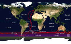
Great capes
Encyclopedia

Sailing
Sailing is the propulsion of a vehicle and the control of its movement with large foils called sails. By changing the rigging, rudder, and sometimes the keel or centre board, a sailor manages the force of the wind on the sails in order to move the boat relative to its surrounding medium and...
, the great capes are the three major cape
Headlands and bays
Headlands and bays are two related features of the coastal environment.- Geology and geography :Headlands and bays are often found on the same coastline. A bay is surrounded by land on three sides, whereas a headland is surrounded by water on three sides. Headlands are characterized by high,...
s of the Southern Ocean
Southern Ocean
The Southern Ocean comprises the southernmost waters of the World Ocean, generally taken to be south of 60°S latitude and encircling Antarctica. It is usually regarded as the fourth-largest of the five principal oceanic divisions...
— the Cape of Good Hope
Cape of Good Hope
The Cape of Good Hope is a rocky headland on the Atlantic coast of the Cape Peninsula, South Africa.There is a misconception that the Cape of Good Hope is the southern tip of Africa, because it was once believed to be the dividing point between the Atlantic and Indian Oceans. In fact, the...
(although sometimes Cape Agulhas
Cape Agulhas
Cape Agulhas is a rocky headland in the Western Cape, South Africa. It is the geographic southern tip of Africa and the official dividing point between the Atlantic and Indian oceans...
is cited in its place), Cape Leeuwin
Cape Leeuwin
Cape Leeuwin is the most south-westerly mainland point of the Australian Continent, in the state of Western Australia.A few small islands and rocks, the St Alouarn Islands, extend further to the south. The nearest settlement, north of the cape, is Augusta. South-east of Cape Leeuwin, the coast...
, and Cape Horn
Cape Horn
Cape Horn is the southernmost headland of the Tierra del Fuego archipelago of southern Chile, and is located on the small Hornos Island...
. South East Cape
South East Cape
South East Cape is the southernmost point of the main island of Tasmania, the southernmost state of Australia. South East Cape is located at ....
of Tasmania
Tasmania
Tasmania is an Australian island and state. It is south of the continent, separated by Bass Strait. The state includes the island of Tasmania—the 26th largest island in the world—and the surrounding islands. The state has a population of 507,626 , of whom almost half reside in the greater Hobart...
and South West Cape
South West Cape, New Zealand
South West Cape, located at , is a cape on the south coast of Stewart Island, New Zealand. It is the southernmost point on the island, and as such is almost the southernmost point on the main chain of islands that make up New Zealand, beaten to that honour by the tiny Murphy Island, which lies...
at the southern tip of Stewart Island/Rakiura
Stewart Island/Rakiura
Stewart Island/Rakiura is the third-largest island of New Zealand. It lies south of the South Island, across Foveaux Strait. Its permanent population is slightly over 400 people, most of whom live in the settlement of Oban.- History and naming :...
are also sometimes included as major landmarks of a circumnavigation
Circumnavigation
Circumnavigation – literally, "navigation of a circumference" – refers to travelling all the way around an island, a continent, or the entire planet Earth.- Global circumnavigation :...
. The traditional clipper route
Clipper route
In sailing, the clipper route was the traditional route sailed by clipper ships between Europe and the Far East, Australia and New Zealand. The route ran from west to east through the Southern Ocean, in order to make use of the strong westerly winds of the Roaring Forties...
followed the winds of the roaring forties
Roaring Forties
The Roaring Forties is the name given to strong westerly winds found in the Southern Hemisphere, generally between the latitudes of 40 and 49 degrees. Air displaced from the Equator towards the South Pole, which travels close to the surface between the latitudes of 30 and 60 degrees south, combines...
south of these capes; due to the significant hazards they presented to ships, they became significant landmarks in ocean voyaging.
Today, the capes feature prominently in ocean yacht racing
Yacht racing
Yacht racing is the sport of competitive yachting.While sailing groups organize the most active and popular competitive yachting, other boating events are also held world-wide: speed motorboat racing; competitive canoeing, kayaking, and rowing; model yachting; and navigational contests Yacht racing...
, with many races and individual sailors following the clipper route. A circumnavigation
Circumnavigation
Circumnavigation – literally, "navigation of a circumference" – refers to travelling all the way around an island, a continent, or the entire planet Earth.- Global circumnavigation :...
via the great capes is considered to be a noteworthy achievement.
In his book The Long Way, Bernard Moitessier
Bernard Moitessier
Bernard Moitessier was a renowned French yachtsman and author of books about his voyages and sailing....
tries to express the significance to a sailor of the great capes:
- A sailor's geography is not always that of the cartographer, for whom a cape is a cape, with a latitude and longitude. For the sailor, a great cape is both a very simple and an extremely complicated whole of rocks, currents, breaking seas and huge waves, fair winds and gales, joys and fears, fatigue, dreams, painful hands, empty stomachs, wonderful moments, and suffering at times.
- A great cape, for us, can't be expressed in longitude and latitude alone. A great cape has a soul, with very soft, very violent shadows and colours. A soul as smooth as a child's, as hard as a criminal's. And that is why we go.

