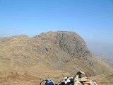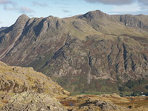
Harrison Stickle
Encyclopedia
Harrison Stickle is a fell
in the central part
of the English Lake District
, situated above Great Langdale
. The fell is one of the three (although the number is debated) fells which make up the picturesque Langdale Pikes, the others being Pike of Stickle
and Loft Crag
. Together they make up one of the most picturesque, and probably the best known, mountain groups in the District. A "stickle" is a hill with a prominent rocky top.
. Harrison Stickle is the high point of this system and its crags fall south and east from the summit, presenting an arresting view from the valley floor 2,000 ft below, or from further afield.
To the north, the main ridge of the central fells passes over Thunacar Knott before climbing to High Raise
. The craggy eastern face of this ridge continues north as far as Harrison's near neighbour, Pavey Ark
, visually the most impressive face in the area. The south western border of Harrison Stickle is formed by the deep ravine of Dungeon Ghyll, which cuts through the parapet of the Langdale Pikes and into the lower hinterland of Harrison Combe. Across the Ghyll westwards are Thorn Crag, Loft Crag and finally Pike of Stickle. Below the steep eastern face of Harrison Stickle lie Stickle Tarn
and its ghyll, thus ensuring that all drainage from the fell is to Great Langdale. The tarn
is a waterfilled corrie about 50 ft deep, this being enhanced by a dam. The water is used for public consumption in Great Langdale.
and breccia
of the Pavey Ark Member.. There is no history of mining.
to Stickle Tarn
; a path then leads up the western side of Pavey Ark to reach the summit. The fell is almost invariably combined with other nearby peaks to make a longer circular walk.
Fell
“Fell” is a word used to refer to mountains, or certain types of mountainous landscape, in Scandinavia, the Isle of Man, and parts of northern England.- Etymology :...
in the central part
Central Fells
The Central Fells are a group of hills in the English Lake District. Reaching their highest point at High Raise , they occupy a broad area to the east of Borrowdale. Perhaps unexpectedly the Central Fells are generally lower than the surrounding hills, the Lake District's general dome-like...
of the English Lake District
Lake District
The Lake District, also commonly known as The Lakes or Lakeland, is a mountainous region in North West England. A popular holiday destination, it is famous not only for its lakes and its mountains but also for its associations with the early 19th century poetry and writings of William Wordsworth...
, situated above Great Langdale
Great Langdale
Great Langdale is a valley in the Lake District National Park in the county of Cumbria, in the northwest of England. It is often simply referred to as Langdale, the epithet Great distinguishing it from the neighbouring valley of Little Langdale....
. The fell is one of the three (although the number is debated) fells which make up the picturesque Langdale Pikes, the others being Pike of Stickle
Pike of Stickle
Pike of Stickle, also known as Pike O’ Stickle, is a fell in the English Lake District. It reaches a height of 709 metres and is situated in the central part of the national park in the valley of Great Langdale...
and Loft Crag
Loft Crag
Loft Crag is a fell in the English Lake District, it is situated 9 kilometres west of Ambleside in the valley of Great Langdale and along with the neighbouring fells of Harrison Stickle and Pike of Stickle it forms the picturesque Langdale Pikes which when viewed from the area around...
. Together they make up one of the most picturesque, and probably the best known, mountain groups in the District. A "stickle" is a hill with a prominent rocky top.
Topography
The Langdale Pikes form a raised rocky parapet around the southern and eastern edges of a high tableland centred upon Thunacar KnottThunacar Knott
Thunacar Knott is a fell in the central part of the English Lake District in the county of Cumbria.-Topography:The main spine of the Central Fells runs south from Bleaberry Fell to High Raise, before turning sharply east en route for Blea Rigg and Loughrigg Fell. A secondary ridge projects...
. Harrison Stickle is the high point of this system and its crags fall south and east from the summit, presenting an arresting view from the valley floor 2,000 ft below, or from further afield.
To the north, the main ridge of the central fells passes over Thunacar Knott before climbing to High Raise
High Raise (Langdale)
High Raise is a fell in the Central Fells of the English Lake District not to be confused with another High Raise situated in the Far Eastern Fells...
. The craggy eastern face of this ridge continues north as far as Harrison's near neighbour, Pavey Ark
Pavey Ark
Pavey Ark is a fell in the English county of Cumbria. It is one of the Langdale Pikes, lying to the north of Great Langdale, in the heart of the Lake District, immediately to the north-east of Harrison Stickle.-Topography:...
, visually the most impressive face in the area. The south western border of Harrison Stickle is formed by the deep ravine of Dungeon Ghyll, which cuts through the parapet of the Langdale Pikes and into the lower hinterland of Harrison Combe. Across the Ghyll westwards are Thorn Crag, Loft Crag and finally Pike of Stickle. Below the steep eastern face of Harrison Stickle lie Stickle Tarn
Stickle Tarn
Stickle Tarn is a small tarn near Harrison Stickle in Lake District, England.The tarn was enlarged by the building of a stone dam in 1838 and is used to supply water for the inhabitants of Langdale....
and its ghyll, thus ensuring that all drainage from the fell is to Great Langdale. The tarn
Tarn (lake)
A tarn is a mountain lake or pool, formed in a cirque excavated by a glacier. A moraine may form a natural dam below a tarn. A corrie may be called a cirque.The word is derived from the Old Norse word tjörn meaning pond...
is a waterfilled corrie about 50 ft deep, this being enhanced by a dam. The water is used for public consumption in Great Langdale.

Geology
Harrison Stickle's summit area is composed of the pebbly sandstoneSandstone
Sandstone is a sedimentary rock composed mainly of sand-sized minerals or rock grains.Most sandstone is composed of quartz and/or feldspar because these are the most common minerals in the Earth's crust. Like sand, sandstone may be any colour, but the most common colours are tan, brown, yellow,...
and breccia
Breccia
Breccia is a rock composed of broken fragments of minerals or rock cemented together by a fine-grained matrix, that can be either similar to or different from the composition of the fragments....
of the Pavey Ark Member.. There is no history of mining.
Summit and view
The summit is a short rocky ridge with a cairn at each end, the northern one being higher. The view from Harrison Stickle is as good as the view of it — a surprisingly rare occurrence — with all of the major fell groups visible.Ascents
The fell is usually climbed from New Dungeon Ghyll Hotel in Great Langdale, and there are a number of possible routes up. The simplest first follows Stickle BeckStream
A stream is a body of water with a current, confined within a bed and stream banks. Depending on its locale or certain characteristics, a stream may be referred to as a branch, brook, beck, burn, creek, "crick", gill , kill, lick, rill, river, syke, bayou, rivulet, streamage, wash, run or...
to Stickle Tarn
Stickle Tarn
Stickle Tarn is a small tarn near Harrison Stickle in Lake District, England.The tarn was enlarged by the building of a stone dam in 1838 and is used to supply water for the inhabitants of Langdale....
; a path then leads up the western side of Pavey Ark to reach the summit. The fell is almost invariably combined with other nearby peaks to make a longer circular walk.

