

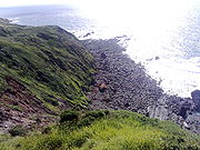
Hartland Point
Encyclopedia

Devon
Devon is a large county in southwestern England. The county is sometimes referred to as Devonshire, although the term is rarely used inside the county itself as the county has never been officially "shired", it often indicates a traditional or historical context.The county shares borders with...
coast in England
England
England is a country that is part of the United Kingdom. It shares land borders with Scotland to the north and Wales to the west; the Irish Sea is to the north west, the Celtic Sea to the south west, with the North Sea to the east and the English Channel to the south separating it from continental...
. It is three miles (5 km) north-west of the village of Hartland
Hartland, Devon
The town of Hartland, which incorporates the hamlet of Stoke to the west and the village of Meddon in the south, is the most north-westerly settlement in the county of Devon, England....
. The point marks the western limit (on the English side) of the Bristol Channel
Bristol Channel
The Bristol Channel is a major inlet in the island of Great Britain, separating South Wales from Devon and Somerset in South West England. It extends from the lower estuary of the River Severn to the North Atlantic Ocean...
with the Atlantic Ocean
Atlantic Ocean
The Atlantic Ocean is the second-largest of the world's oceanic divisions. With a total area of about , it covers approximately 20% of the Earth's surface and about 26% of its water surface area...
continuing to the west. This location was known to the Romans as the "promontory of Hercules".
Lighthouse
Trinity HouseTrinity House
The Corporation of Trinity House of Deptford Strond is the official General Lighthouse Authority for England, Wales and other British territorial waters...
, the lighthouse authority for England
England
England is a country that is part of the United Kingdom. It shares land borders with Scotland to the north and Wales to the west; the Irish Sea is to the north west, the Celtic Sea to the south west, with the North Sea to the east and the English Channel to the south separating it from continental...
and Wales
Wales
Wales is a country that is part of the United Kingdom and the island of Great Britain, bordered by England to its east and the Atlantic Ocean and Irish Sea to its west. It has a population of three million, and a total area of 20,779 km²...
, have a lighthouse on the tip of the peninsula. The Hartland Point Lighthouse
Hartland Point Lighthouse
Hartland Point Lighthouse is a Grade II listed building at Hartland Point, Devon, England. The point marks the western limit of the Bristol Channel with the Atlantic Ocean continuing to the west....
was built in 1874 under the direction of Sir James Douglass
James Nicholas Douglass
Sir James Nicholas Douglass, FRS, , was an English civil engineer, a prolific lighthouse builder and designer, most famous for the design and construction of the fourth Eddystone Lighthouse, for which he was knighted....
, the Grade II listed tower is 18 metres (59.1 ft) tall with the lamp being 37 metres (121.4 ft) above mean sea level. The light can be seen up to 25 miles (40.2 km) away from the coast.. It was blessed by Frederick Temple
Frederick Temple
Frederick Temple was an English academic, teacher, churchman and Archbishop of Canterbury from 1896 until his death.-Early life:...
, Bishop of Exeter
Bishop of Exeter
The Bishop of Exeter is the Ordinary of the Church of England Diocese of Exeter in the Province of Canterbury. The incumbent usually signs his name as Exon or incorporates this in his signature....
, who later became Archbishop of Canterbury
Archbishop of Canterbury
The Archbishop of Canterbury is the senior bishop and principal leader of the Church of England, the symbolic head of the worldwide Anglican Communion, and the diocesan bishop of the Diocese of Canterbury. In his role as head of the Anglican Communion, the archbishop leads the third largest group...
. The tower was automated in 1984 and is now controlled from Trinity House Operations Centre at Harwich
Harwich
Harwich is a town in Essex, England and one of the Haven ports, located on the coast with the North Sea to the east. It is in the Tendring district. Nearby places include Felixstowe to the northeast, Ipswich to the northwest, Colchester to the southwest and Clacton-on-Sea to the south...
in Essex
Essex
Essex is a ceremonial and non-metropolitan county in the East region of England, and one of the home counties. It is located to the northeast of Greater London. It borders with Cambridgeshire and Suffolk to the north, Hertfordshire to the west, Kent to the South and London to the south west...
. Prior to automation the lighthouse was built with accommodation for four keepers and their families. The keepers' dwellings have since been demolished to make room for a Helipad
Helipad
Helipad is a common abbreviation for helicopter landing pad, a landing area for helicopters. While helicopters are able to operate on a variety of relatively flat surfaces, a fabricated helipad provides a clearly marked hard surface away from obstacles where a helicopter can safely...
to be constructed. This was necessary due to the precarious nature of the access road which is liable to frequent rock falls and landslips. Vehicular access is now very difficult and the gates tend to remain locked. The large concrete structures immediately to the south of the lighthouse were to provide the keepers with fresh water.
In the 2010 Aids to Navigation Review, by Trinity House, they proposed to discontinue the Hartland Point Lighthouse Station on grounds that Global Positioning System
Global Positioning System
The Global Positioning System is a space-based global navigation satellite system that provides location and time information in all weather, anywhere on or near the Earth, where there is an unobstructed line of sight to four or more GPS satellites...
s are superseding lighthouses as the most important navigation aids.
Characteristics
| Light | White group flashing six times every fifteen seconds |
|---|---|
| Fog horn | One five-second blast every minute |
Coastguard

The South West Coast Path
South West Coast Path
The South West Coast Path is Britain's longest waymarked long-distance footpath and a National Trail. It stretches for , running from Minehead in Somerset, along the coasts of Devon and Cornwall, to Poole Harbour in Dorset. Since it rises and falls with every river mouth, it is also one of the more...
was formerly an aid to the Coastguard who needed to be able to travel from station to station on foot while being able to keep an eye on the sea to spot for smugglers. The path stays close to the edge of the cliffs on its journey through Hartland Point and it is an ideal way to explore the point, its landmarks and the scenery.
Radar Station

Ministry of Defence (United Kingdom)
The Ministry of Defence is the United Kingdom government department responsible for implementation of government defence policy and is the headquarters of the British Armed Forces....
have a radar station installed on the point and controlled from nearby RAF Hartland Point. This is used for air traffic control of both military and civilian aircraft. The unusual white-dome-topped structure can be seen from distances of up to 10 miles (16.1 km) from the point.
MS Johanna
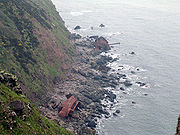
Wheat
Wheat is a cereal grain, originally from the Levant region of the Near East, but now cultivated worldwide. In 2007 world production of wheat was 607 million tons, making it the third most-produced cereal after maize and rice...
from The Netherlands up the Bristol Channel
Bristol Channel
The Bristol Channel is a major inlet in the island of Great Britain, separating South Wales from Devon and Somerset in South West England. It extends from the lower estuary of the River Severn to the North Atlantic Ocean...
towards Cardiff
Cardiff
Cardiff is the capital, largest city and most populous county of Wales and the 10th largest city in the United Kingdom. The city is Wales' chief commercial centre, the base for most national cultural and sporting institutions, the Welsh national media, and the seat of the National Assembly for...
. Four of the crew were rescued by a helicopter from RAF Chivenor
Royal Marines Base Chivenor
Royal Marines Base Chivenor is a British military base used primarily by the Royal Marines. It is situated on the northern shore of the Taw estuary, adjacent to the South West Coast Path, on the north coast of Devon, England....
. Three officers were taken off later in the day by the RNLI lifeboat from Clovelly
Clovelly
Clovelly is a village in the Torridge district of Devon, England. It is a major tourist attraction, famous for its history and beauty, its extremely steep car-free cobbled main street, donkeys, and its location looking out over the Bristol Channel. Thick woods shelter it and render the climate so...
. The decaying remains of the hull can still be seen.