

Hawaii Route 92
Encyclopedia
Oahu
Oahu or Oahu , known as "The Gathering Place", is the third largest of the Hawaiian Islands and most populous of the islands in the U.S. state of Hawaii. The state capital Honolulu is located on the southeast coast...
which begins at exit 15 off Interstate H-1
Interstate H-1
Interstate H-1 is the busiest Interstate Highway in Hawaii, United States, located on the island of O‘ahu. Despite the number, this is an east–west highway—the 'H'-series numbering reflects the order in which routes were funded and built. H-1 goes from Route 93 in Kapolei to Route 72 in...
in Honolulu
Honolulu, Hawaii
Honolulu is the capital and the most populous city of the U.S. state of Hawaii. Honolulu is the southernmost major U.S. city. Although the name "Honolulu" refers to the urban area on the southeastern shore of the island of Oahu, the city and county government are consolidated as the City and...
and ends 0.6 mile (0.965604 km) east of the Ala Wai Canal
Ala Wai Canal
The Ala Wai Canal is an artificial waterway in Honolulu, Hawaii which serves as the northern boundary of the tourist district of Waikīkī. It was created in 1928 for the purpose of draining the rice paddies and swamps which would eventually become the tourist resort area of Waikiki, and today also...
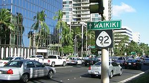
crossing in Waikiki
Waikiki
Waikiki is a neighborhood of Honolulu, in the City and County of Honolulu, on the south shore of the island of Oahu, in Hawaii. Waikiki Beach is the shoreline fronting Waikīkī....
. The western portion, west of Richards Street, is also known as the Nimitz Highway (named after Pacific Fleet Admiral during World War II, Chester Nimitz
Chester Nimitz
Fleet Admiral Chester William Nimitz, GCB, USN was a five-star admiral in the United States Navy. He held the dual command of Commander in Chief, United States Pacific Fleet , for U.S. naval forces and Commander in Chief, Pacific Ocean Areas , for U.S...
). And the eastern portion, east of Richards Street, is also known as the Ala Moana Boulevard.
Route description
After exiting Interstate H-1, Route 92 goes past the Pearl Harbor Naval BasePearl Harbor
Pearl Harbor, known to Hawaiians as Puuloa, is a lagoon harbor on the island of Oahu, Hawaii, west of Honolulu. Much of the harbor and surrounding lands is a United States Navy deep-water naval base. It is also the headquarters of the U.S. Pacific Fleet...
and Hickam Air Force Base
Hickam Air Force Base
Hickam Field, re-named Hickam Air Force Base in 1948, was a United States Air Force facility now part of Joint Base Pearl Harbor-Hickam, named in honor of aviation pioneer Lt Col Horace Meek Hickam.- History :...
gates. Route 92 goes under the Airport Viaduct (Interstate H-1) and serves primary route for Honolulu International Airport
Honolulu International Airport
Honolulu International Airport is the principal aviation gateway of the City & County of Honolulu and the State of Hawaii and is identified as one of the busiest airports in the United States, with traffic now exceeding 21 million passengers a year and rising.It is located in the Honolulu...
. Route 92 briefly cosigns with Interstate H-1 before exiting off again at exit 18. Heading east, Route 92 enters into the Port of Honolulu and downtown Honolulu
Downtown Honolulu
Downtown Honolulu is the current historic, economic, governmental, and central part of Honolulu—bounded by Nuuanu Stream to the west, Ward Avenue to the east, Vineyard Boulevard to the north, and Honolulu Harbor to the south—situated within the larger Honolulu District...
. After crossing the Ala Wai Canal to Waikiki, Route 92 ends and county jurisdiction is transferred at that point.
History
The route was constructed in the 1940s during World War IIWorld War II
World War II, or the Second World War , was a global conflict lasting from 1939 to 1945, involving most of the world's nations—including all of the great powers—eventually forming two opposing military alliances: the Allies and the Axis...
to serve military facilities and the local airport. There were plans in the 1960s to extend the road east of the Ala Moana Shopping Center toward Interstate H-1
Interstate H-1
Interstate H-1 is the busiest Interstate Highway in Hawaii, United States, located on the island of O‘ahu. Despite the number, this is an east–west highway—the 'H'-series numbering reflects the order in which routes were funded and built. H-1 goes from Route 93 in Kapolei to Route 72 in...
once again, but those plans were dropped by the late 1970s.