
Helmstedt-Marienborn border crossing
Encyclopedia
The Border checkpoint Helmstedt–Marienborn , named Grenzübergangsstelle Marienborn (GÜSt) (border crossing Marienborn) by the German Democratic Republic
(GDR), was the largest and most important border crossing on the Inner German border during the division of Germany
. Due to its geographical location, allowing for the shortest land route between West Germany
and West Berlin
, most transit traffic to and from West Berlin used the Helmstedt-Marienborn crossing. Most travel routes from West Germany to East Germany
and Poland
also used this crossing. The border crossing existed from 1945 to 1990 and was situated near the East German village of Marienborn
at the edge of the Lappwald
. The crossing interrupted the Bundesautobahn 2 between the junctions Helmstedt
-Ost and Ostingersleben
.
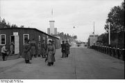
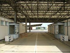 A checkpoint was established on the site on 1 July 1945, which was on the demarcation line between the British
and Soviet
occupation zones
. Its scope included the interzonal railway traffic as well as the motor vehicle traffic on the Reichsautobahn between Hanover
and Berlin
. The checkpoint buildings were located directly on the zones' border, and consisted of little more than temporary wooden buildings.
The most important inner-German checkpoint, the Autobahn crossing at Helmstedt was named Alpha by the Western Allies
. Its counterpart in the Berlin southern borough of Dreilinden was named Bravo. The connection between these checkpoints gained its importance from being the shortest connection between the western zones and Berlin, at 170 km (105.6 mi). During the Berlin Blockade
, which endured from June 1948 to May 1949, the Soviet checkpoint was closed.
From 1950 onwards, the East German Grenzpolizei
(later the Grenztruppen der DDR) performed the border control on the eastern side of the checkpoint, with the exception of the Soviet military, which escorted Allied military traffic to and from West Berlin. Due to the increasing tensions between the Western Allies and the Soviet Union during the Cold War
, the border crossing was expanded extensively and security was increased during the following years. However, the original checkpoint was eventually regarded too unsafe to operate efficiently.

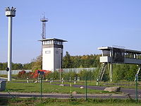
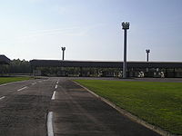 Between 1972 and 1974, the GDR erected a new control portal on a 35 hectare
field situated on a hill near Marienborn, about 1.5 km east of the border. The control portal was staffed with as many as 1,000 passport control, customs and border police employees. The buildings were linked with an underground tunnel system through which military or police units could reach the control portal quickly and secretly.
The Western Allies kept control of their checkpoint on the western side, with small garrisons of French, British and American troops stationed in Helmstedt. The West German Bundesgrenzschutz
had assumed control of the operative controls on the western side of the border crossing, where the buildings were notably smaller compared with Marienborn.
 The restrictive East German controls and the ever-increasing amount of traffic soon resulted in notable waiting times on the West German side. Therefore, the West German government added extraneous car parks and rest stops on the autobahn approach to Helmstedt.
Border controls were relaxed after the Wende
during late 1989. The crossing was dismantled at midnight on June 30, 1990, exactly 45 years after its first opening. The former GDR buildings have been a listed building since October 1990, however the former GDR departures area has been demolished when the A 2 road was expanded to six lanes. A rest stop with a motel has now been built on part of the old GDR control portal's area.
. The Allied side of the checkpoint for entry into West Berlin was named Checkpoint Bravo
, while Checkpoint Charlie
was the Allied checkpoint for entry into (and exit from) East Berlin
.
The nomenclature of "checkpoint", as opposed to the East German "Grenzübergangsstelle" (which literally means "border-crossing-place") was a result of the Western Allies not recognising the legitimacy of East Germany as a state. This only changed during 1973 when the GDR was admitted to the United Nations
, however the term remained in use.
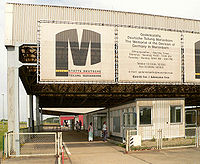 On the grounds of the former East German border control buildings, the "Gedenkstätte Deutsche Teilung Marienborn" was opened on August 13, 1996. The memorial is operated by the state of Saxony-Anhalt
and features exhibitions and guided tours. The memorial site is accessible via the nearby rest stop's exit and can only be explored afoot.
The West German buildings near Helmstedt have either been demolished or are now used for other purposes.
German Democratic Republic
The German Democratic Republic , informally called East Germany by West Germany and other countries, was a socialist state established in 1949 in the Soviet zone of occupied Germany, including East Berlin of the Allied-occupied capital city...
(GDR), was the largest and most important border crossing on the Inner German border during the division of Germany
History of Germany since 1945
As a consequence of the defeat of Nazi Germany in World War II Germany was split between the two global blocs in the East and West, a period known as the division of Germany. While seven million prisoners and forced laborers left Germany, over 10 million German speaking refugees arrived there from...
. Due to its geographical location, allowing for the shortest land route between West Germany
West Germany
West Germany is the common English, but not official, name for the Federal Republic of Germany or FRG in the period between its creation in May 1949 to German reunification on 3 October 1990....
and West Berlin
West Berlin
West Berlin was a political exclave that existed between 1949 and 1990. It comprised the western regions of Berlin, which were bordered by East Berlin and parts of East Germany. West Berlin consisted of the American, British, and French occupation sectors, which had been established in 1945...
, most transit traffic to and from West Berlin used the Helmstedt-Marienborn crossing. Most travel routes from West Germany to East Germany
German Democratic Republic
The German Democratic Republic , informally called East Germany by West Germany and other countries, was a socialist state established in 1949 in the Soviet zone of occupied Germany, including East Berlin of the Allied-occupied capital city...
and Poland
Poland
Poland , officially the Republic of Poland , is a country in Central Europe bordered by Germany to the west; the Czech Republic and Slovakia to the south; Ukraine, Belarus and Lithuania to the east; and the Baltic Sea and Kaliningrad Oblast, a Russian exclave, to the north...
also used this crossing. The border crossing existed from 1945 to 1990 and was situated near the East German village of Marienborn
Marienborn
Marienborn is a village and a former municipality in the Börde district in Saxony-Anhalt, Germany. Since 1 January 2010, it has been part of the municipality of Sommersdorf. It is about southwest of Haldensleben...
at the edge of the Lappwald
Lappwald
The Lappwald is a heavily wooded range of hills, 20 km long and up to 5 km wide, in central Germany. It stretches northwards from the town of Helmstedt. The border between Lower Saxony and Saxony-Anhalt runs through the woods, of which about three quarters is on Lower Saxon terrain...
. The crossing interrupted the Bundesautobahn 2 between the junctions Helmstedt
Helmstedt
Helmstedt is a city located at the eastern edge of the German state of Lower Saxony. It is the capital of the District of Helmstedt. Helmstedt has 26,000 inhabitants . In former times the city was also called Helmstädt....
-Ost and Ostingersleben
Ostingersleben
Ostingersleben is a village and a former municipality in the Börde district in Saxony-Anhalt, Germany. Since 1 January 2010, it is part of the municipality Ingersleben....
.
First checkpoints


Great Britain
Great Britain or Britain is an island situated to the northwest of Continental Europe. It is the ninth largest island in the world, and the largest European island, as well as the largest of the British Isles...
and Soviet
Soviet Union
The Soviet Union , officially the Union of Soviet Socialist Republics , was a constitutionally socialist state that existed in Eurasia between 1922 and 1991....
occupation zones
Allied Occupation Zones in Germany
The Allied powers who defeated Nazi Germany in World War II divided the country west of the Oder-Neisse line into four occupation zones for administrative purposes during 1945–49. In the closing weeks of fighting in Europe, US forces had pushed beyond the previously agreed boundaries for the...
. Its scope included the interzonal railway traffic as well as the motor vehicle traffic on the Reichsautobahn between Hanover
Hanover
Hanover or Hannover, on the river Leine, is the capital of the federal state of Lower Saxony , Germany and was once by personal union the family seat of the Hanoverian Kings of Great Britain, under their title as the dukes of Brunswick-Lüneburg...
and Berlin
Berlin
Berlin is the capital city of Germany and is one of the 16 states of Germany. With a population of 3.45 million people, Berlin is Germany's largest city. It is the second most populous city proper and the seventh most populous urban area in the European Union...
. The checkpoint buildings were located directly on the zones' border, and consisted of little more than temporary wooden buildings.
The most important inner-German checkpoint, the Autobahn crossing at Helmstedt was named Alpha by the Western Allies
Western Allies
The Western Allies were a political and geographic grouping among the Allied Powers of the Second World War. It generally includes the United Kingdom and British Commonwealth, the United States, France and various other European and Latin American countries, but excludes China, the Soviet Union,...
. Its counterpart in the Berlin southern borough of Dreilinden was named Bravo. The connection between these checkpoints gained its importance from being the shortest connection between the western zones and Berlin, at 170 km (105.6 mi). During the Berlin Blockade
Berlin Blockade
The Berlin Blockade was one of the first major international crises of the Cold War and the first resulting in casualties. During the multinational occupation of post-World War II Germany, the Soviet Union blocked the Western Allies' railway and road access to the sectors of Berlin under Allied...
, which endured from June 1948 to May 1949, the Soviet checkpoint was closed.
From 1950 onwards, the East German Grenzpolizei
Grepo
Grepo is the short form of the German word for border police . It is usually found in English referring to the Grenztruppen der DDR who guarded the inner German border and the Berlin Wall, but can be used to refer to other border police, such as the former Bayerische Grenzpolizei , and the...
(later the Grenztruppen der DDR) performed the border control on the eastern side of the checkpoint, with the exception of the Soviet military, which escorted Allied military traffic to and from West Berlin. Due to the increasing tensions between the Western Allies and the Soviet Union during the Cold War
Cold War
The Cold War was the continuing state from roughly 1946 to 1991 of political conflict, military tension, proxy wars, and economic competition between the Communist World—primarily the Soviet Union and its satellite states and allies—and the powers of the Western world, primarily the United States...
, the border crossing was expanded extensively and security was increased during the following years. However, the original checkpoint was eventually regarded too unsafe to operate efficiently.
Expansion in the 1970s


Hectare
The hectare is a metric unit of area defined as 10,000 square metres , and primarily used in the measurement of land. In 1795, when the metric system was introduced, the are was defined as being 100 square metres and the hectare was thus 100 ares or 1/100 km2...
field situated on a hill near Marienborn, about 1.5 km east of the border. The control portal was staffed with as many as 1,000 passport control, customs and border police employees. The buildings were linked with an underground tunnel system through which military or police units could reach the control portal quickly and secretly.
The Western Allies kept control of their checkpoint on the western side, with small garrisons of French, British and American troops stationed in Helmstedt. The West German Bundesgrenzschutz
Bundesgrenzschutz
Bundesgrenzschutz was the first federal police organization in Western Germany after World War II permitted by the Allied occupation authorities. In July 2005, the BGS was renamed Bundespolizei to reflect its transition to a multi-faceted police agency.It was established in 1951...
had assumed control of the operative controls on the western side of the border crossing, where the buildings were notably smaller compared with Marienborn.

Border controls were relaxed after the Wende
German reunification
German reunification was the process in 1990 in which the German Democratic Republic joined the Federal Republic of Germany , and when Berlin reunited into a single city, as provided by its then Grundgesetz constitution Article 23. The start of this process is commonly referred by Germans as die...
during late 1989. The crossing was dismantled at midnight on June 30, 1990, exactly 45 years after its first opening. The former GDR buildings have been a listed building since October 1990, however the former GDR departures area has been demolished when the A 2 road was expanded to six lanes. A rest stop with a motel has now been built on part of the old GDR control portal's area.
Checkpoint Alpha
The Helmstedt-Marienborn checkpoint was one of three checkpoints used by the Western Allies. Its western side (in the former British zone) was labeled Checkpoint Alpha after the first letter of the NATO spelling alphabetNATO phonetic alphabet
The NATO phonetic alphabet, more accurately known as the NATO spelling alphabet and also called the ICAO phonetic or spelling alphabet, the ITU phonetic alphabet, and the international radiotelephony spelling alphabet, is the most widely used spelling alphabet...
. The Allied side of the checkpoint for entry into West Berlin was named Checkpoint Bravo
Checkpoint Bravo
Checkpoint Bravo was the name given by the Western Allies to the main autobahn border crossing points between West Berlin and the German Democratic Republic It was known in German as Grenzübergangsstelle Drewitz-Dreilinden...
, while Checkpoint Charlie
Checkpoint Charlie
Checkpoint Charlie was the name given by the Western Allies to the best-known Berlin Wall crossing point between East Berlin and West Berlin during the Cold War....
was the Allied checkpoint for entry into (and exit from) East Berlin
East Berlin
East Berlin was the name given to the eastern part of Berlin between 1949 and 1990. It consisted of the Soviet sector of Berlin that was established in 1945. The American, British and French sectors became West Berlin, a part strongly associated with West Germany but a free city...
.
The nomenclature of "checkpoint", as opposed to the East German "Grenzübergangsstelle" (which literally means "border-crossing-place") was a result of the Western Allies not recognising the legitimacy of East Germany as a state. This only changed during 1973 when the GDR was admitted to the United Nations
United Nations
The United Nations is an international organization whose stated aims are facilitating cooperation in international law, international security, economic development, social progress, human rights, and achievement of world peace...
, however the term remained in use.
Division memorial

Saxony-Anhalt
Saxony-Anhalt is a landlocked state of Germany. Its capital is Magdeburg and it is surrounded by the German states of Lower Saxony, Brandenburg, Saxony, and Thuringia.Saxony-Anhalt covers an area of...
and features exhibitions and guided tours. The memorial site is accessible via the nearby rest stop's exit and can only be explored afoot.
The West German buildings near Helmstedt have either been demolished or are now used for other purposes.
Further reading
- Hans-Jürgen Mielke: Die Autobahn Berlin-Helmstedt, Reimer-Verlag 1984, ISBN 3-49600-787-7
- Friedrich Christian Delius and Peter Joachim Lapp, Transit Westberlin. Erlebnisse im Zwischenraum, Berlin: Ch.Links Verlag, 2000. ISBN 3-86153-198-4
Films
- Halt! Hier Grenze - Auf den Spuren der innerdeutschen Grenze, Documentary, Germany 2005

