Henry Arnold Karo
Encyclopedia
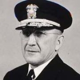
Henry Arnold Karo was a vice admiral
in the former U.S. Coast and Geodetic Survey Corps, which is today known as the National Oceanic and Atmospheric Administration Commissioned Corps. Vice Admiral Karo spent most of his working career in the U.S. National Geodetic Survey
, which provides coastal maps and charts for the nation. He rose through the organization's bureaucracy to become the next to last director of the survey.
Karo had been involved in the survey since 1923, but the advent of World War II
forced him to take on other duties. In this period, he rose to the rank of rear admiral. At war's end, he returned to his work with the survey team.
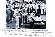
 Karo was transferred from the survey to the Army Air Forces in World War II, when he was commanding officer of the Air Force Aeronautical Chart Center in St. Louis. Initially, he was given the Army Air Forces rank of Major, and he was promoted to Colonel during this period; but Karo returned to the survey as with the Rank of Rear Admiral (see photo caption) at the end of the war.
of length
, usually used to measure distance
; however, the measurement varied amongst a number of national systems. There were (and remain today) some slight differences depending on whether a mile is construed in terms of Imperial unit
s, United States customary units
, or Norwegian/Swedish mil
. In the 1950s, Karo headed the project which established the U.S. survey mile (also known as U.S. statute mile) of 5,280 survey feet which is slightly longer at approximately 1,609.347 219 meters (1 international mile is exactly 0.999 998 survey mile).
He was promoted to Vice Admiral just before he left USC&GS to help create a new government agency which would eventually merge the survey with two other formerly independent agencies.
's predecessor agency, the Environmental Science Services Administration
.
, in Washington, D.C. He was 82 years old.
Vice admiral (United States)
In the United States Navy, the United States Coast Guard, the United States Public Health Service Commissioned Corps, the National Oceanic and Atmospheric Administration Commissioned Corps, and the United States Maritime Service, vice admiral is a three-star flag officer, with the pay grade of...
in the former U.S. Coast and Geodetic Survey Corps, which is today known as the National Oceanic and Atmospheric Administration Commissioned Corps. Vice Admiral Karo spent most of his working career in the U.S. National Geodetic Survey
U.S. National Geodetic Survey
National Geodetic Survey, formerly called the U.S. Coast and Geodetic Survey , is a United States federal agency that defines and manages a national coordinate system, providing the foundation for transportation and communication; mapping and charting; and a large number of applications of science...
, which provides coastal maps and charts for the nation. He rose through the organization's bureaucracy to become the next to last director of the survey.
Karo had been involved in the survey since 1923, but the advent of World War II
World War II
World War II, or the Second World War , was a global conflict lasting from 1939 to 1945, involving most of the world's nations—including all of the great powers—eventually forming two opposing military alliances: the Allies and the Axis...
forced him to take on other duties. In this period, he rose to the rank of rear admiral. At war's end, he returned to his work with the survey team.
World War II

US Coast and Geodetic Survey
President Dwight Eisenhower named Rear Admiral Karo to succeed Rear Admiral Robert Studds as head of the survey in 1955. The recess appointment was subsequently made permanent by Senate confirmation. From 1955 through 1965, Karo directed the survey. In 1957, Karo oversaw an organization with a $10-million budget, 17 ships and 2,000 employees. In that same year, the survey's publications list offered over 2,000 aerial and nautical maps and guides; and over 44-million of its documents were issued.Establishing the US standard mile
A mile is a unitUnits of measurement
A unit of measurement is a definite magnitude of a physical quantity, defined and adopted by convention and/or by law, that is used as a standard for measurement of the same physical quantity. Any other value of the physical quantity can be expressed as a simple multiple of the unit of...
of length
Length
In geometric measurements, length most commonly refers to the longest dimension of an object.In certain contexts, the term "length" is reserved for a certain dimension of an object along which the length is measured. For example it is possible to cut a length of a wire which is shorter than wire...
, usually used to measure distance
Distance
Distance is a numerical description of how far apart objects are. In physics or everyday discussion, distance may refer to a physical length, or an estimation based on other criteria . In mathematics, a distance function or metric is a generalization of the concept of physical distance...
; however, the measurement varied amongst a number of national systems. There were (and remain today) some slight differences depending on whether a mile is construed in terms of Imperial unit
Imperial unit
The system of imperial units or the imperial system is the system of units first defined in the British Weights and Measures Act of 1824, which was later refined and reduced. The system came into official use across the British Empire...
s, United States customary units
United States customary units
United States customary units are a system of measurements commonly used in the United States. Many U.S. units are virtually identical to their imperial counterparts, but the U.S. customary system developed from English units used in the British Empire before the system of imperial units was...
, or Norwegian/Swedish mil
Norwegian/Swedish mil
A mil is a unit of distance, most often used to measure geographic distance, very common in Norway and Sweden. Today, it measures by definition 10 kilometres, but earlier in history it had different values....
. In the 1950s, Karo headed the project which established the U.S. survey mile (also known as U.S. statute mile) of 5,280 survey feet which is slightly longer at approximately 1,609.347 219 meters (1 international mile is exactly 0.999 998 survey mile).
He was promoted to Vice Admiral just before he left USC&GS to help create a new government agency which would eventually merge the survey with two other formerly independent agencies.
Environmental Science Services Administration
From 1967 until his retirement in the same year, he was the deputy administrator of the National Oceanic and Atmospheric AdministrationNational Oceanic and Atmospheric Administration
The National Oceanic and Atmospheric Administration , pronounced , like "noah", is a scientific agency within the United States Department of Commerce focused on the conditions of the oceans and the atmosphere...
's predecessor agency, the Environmental Science Services Administration
Environmental Science Services Administration
The U. S. Environmental Science Services Administration was a United States Federal executive agency created in 1965 as part of a reorganization of the United States Department of Commerce...
.
Later years
Karo died of respiratory failure at Georgetown University HospitalGeorgetown University Hospital
Georgetown University Hospital is one of the national capital area's oldest academic teaching hospitals and is affiliated with Georgetown University School of Medicine. GUH is a not-for-profit, acute-care teaching and research facility located in Northwest Washington, DC...
, in Washington, D.C. He was 82 years old.

