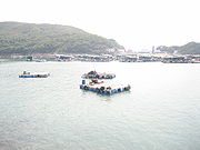
High Island, Hong Kong
Encyclopedia

Chinese language
The Chinese language is a language or language family consisting of varieties which are mutually intelligible to varying degrees. Originally the indigenous languages spoken by the Han Chinese in China, it forms one of the branches of Sino-Tibetan family of languages...
糧船灣洲) is a former island in the southeast of Sai Kung Peninsula
Sai Kung Peninsula
Sai Kung Peninsula is a peninsula in the easternmost part of the New Territories in Hong Kong. Its name comes from Sai Kung Town in the central southern area of the peninsula...
, Hong Kong
Hong Kong
Hong Kong is one of two Special Administrative Regions of the People's Republic of China , the other being Macau. A city-state situated on China's south coast and enclosed by the Pearl River Delta and South China Sea, it is renowned for its expansive skyline and deep natural harbour...
. The island was connected to the peninsula by two dams to enclose the Kwun Mun Channel and form the High Island Reservoir
High Island Reservoir
The High Island Reservoir , located in the far south eastern part of the Sai Kung Peninsula, was opened in 1978 helping to alleviate water shortage problems in Hong Kong. Its water capacity is approximately 273 million cubic metres...
. The construction of the dam spanned 10 years from 1969 to 1979. The area is now a designated fish culture zone and features several seafood restaurants along the shore.
Geography
High Island had historically an area of 8.511 km² and was in 1960 the 4th largest island of Hong Kong. There are four villages, Pak A (北丫), Tung A (東丫), Sha Kiu Tau (沙橋頭) and Pak Lap (白腊), all located along the west coast.Tin Hau Temple
There is a Tin Hau TempleTin Hau temples in Hong Kong
Over 70 temples are dedicated to Tin Hau in Hong Kong. They include:* Tin Hau temple, located at 10 Tin Hau Temple Road, Causeway Bay, east of Victoria Park, in Eastern District, on Hong Kong Island. It is a declared monument. The temple has given its name to the MTR station serving it .* The Tin...
on High Island, located near Tung A. Built in 1741, it is one of the two temples which have marine parade to celebrate the Tin Hau Festival (天后誕). The other is the Tin Hau Temple in Tap Mun
Tap Mun
Grass Island or Tap Mun is an island in Hong Kong, located in the northeastern part of the territory. Its area is 1.69 km². Administratively, it is part of the Tai Po District. There are about 100 people living on the island.-Location:...
which has it once every ten years. The Tin Hau Festival at High Island takes place every two years. The religious ceremony lasts six days and the marine parade is held on the eve of Tin Hau's birthday. The temple was listed as a Grade II historic building
Heritage conservation in Hong Kong
This article details the history and status of Heritage conservation in Hong Kong, as well as the role of various stakeholders.An indication of the size of the built heritage in Hong Kong is given by a territory-wide survey conducted by the Antiquities and Monuments Office between 1996 and 2000,...
in 1996, and as a Grade III historic building in 2010.

