Horseshoe Lake, Arkansas
Encyclopedia
Horseshoe Lake is a town in Crittenden County, Arkansas
, United States
. The population was 321 at the 2000 census.
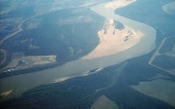
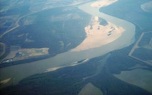
The town is named after Horseshoe Lake, a horseshoe
-shaped lake at the eastern tip of which the town is located.
According to the United States Census Bureau
, the town has a total area of 0.4 km² (0.1 mi²), all land.
The elevation above sea level of Horseshoe Lake is 203 ft (61.9 m).
 The town of Horseshoe Lake is situated in the Mississippi River
flood plains at the eastern tip of a U-shaped water body named Horseshoe Lake, which the town is named after. Horseshoe Lake is approximately 30 minutes by car from downtown Memphis, Tennessee
.
Changes in the course of the Mississippi River resulted in the shape of the lake. The Horseshoe Lake is a former meander
in the Mississippi River that was cut off, shortening the river, and is no longer connected to the river.
Horseshoe shaped lakes or oxbow lakes
are not unusual in the flat plains of the lower Mississippi River and deltas of other rivers.
of 2000, there were 321 people, 156 households, and 89 families residing in the town. The population density
was 885.3/km² (2,264.4/mi²). There were 241 housing units at an average density of 664.6/km² (1,700.1/mi²). The racial makeup of the town was 94.39% White
, 5.30% Black
or African American
, 0.31% from other races
. 0.31% of the population were Hispanic
or Latino
of any race.
 There were 156 households out of which 18.6% had children under the age of 18 living with them, 47.4% were married couples
living together, 4.5% had a female householder with no husband present, and 42.9% were non-families. 35.9% of all households were made up of individuals and 16.7% had someone living alone who was 65 years of age or older. The average household size was 2.06 and the average family size was 2.65.
In the town the population was spread out with 17.4% under the age of 18, 4.0% from 18 to 24, 26.2% from 25 to 44, 27.4% from 45 to 64, and 24.9% who were 65 years of age or older. The median age was 47 years. For every 100 females there were 92.2 males. For every 100 females age 18 and over, there were 89.3 males.
The median income for a household in the town was $30,083, and the median income for a family was $36,250. Males had a median income of $29,583 versus $23,750 for females. The per capita income
for the town was $17,517. About 4.9% of families and 10.2% of the population were below the poverty line, including 3.9% of those under age 18 and 20.5% of those age 65 or over.
Arkansas
Arkansas is a state located in the southern region of the United States. Its name is an Algonquian name of the Quapaw Indians. Arkansas shares borders with six states , and its eastern border is largely defined by the Mississippi River...
, United States
United States
The United States of America is a federal constitutional republic comprising fifty states and a federal district...
. The population was 321 at the 2000 census.
The town is named after Horseshoe Lake, a horseshoe
Horseshoe
A horseshoe, is a fabricated product, normally made of metal, although sometimes made partially or wholly of modern synthetic materials, designed to protect a horse's hoof from wear and tear. Shoes are attached on the palmar surface of the hooves, usually nailed through the insensitive hoof wall...
-shaped lake at the eastern tip of which the town is located.
Geography
Horseshoe Lake is located at 34°54′46"N 90°18′27"W (34.912702, -90.307523).According to the United States Census Bureau
United States Census Bureau
The United States Census Bureau is the government agency that is responsible for the United States Census. It also gathers other national demographic and economic data...
, the town has a total area of 0.4 km² (0.1 mi²), all land.
The elevation above sea level of Horseshoe Lake is 203 ft (61.9 m).
The Horseshoe Lake

Mississippi River
The Mississippi River is the largest river system in North America. Flowing entirely in the United States, this river rises in western Minnesota and meanders slowly southwards for to the Mississippi River Delta at the Gulf of Mexico. With its many tributaries, the Mississippi's watershed drains...
flood plains at the eastern tip of a U-shaped water body named Horseshoe Lake, which the town is named after. Horseshoe Lake is approximately 30 minutes by car from downtown Memphis, Tennessee
Memphis, Tennessee
Memphis is a city in the southwestern corner of the U.S. state of Tennessee, and the county seat of Shelby County. The city is located on the 4th Chickasaw Bluff, south of the confluence of the Wolf and Mississippi rivers....
.
Changes in the course of the Mississippi River resulted in the shape of the lake. The Horseshoe Lake is a former meander
Meander
A meander in general is a bend in a sinuous watercourse. A meander is formed when the moving water in a stream erodes the outer banks and widens its valley. A stream of any volume may assume a meandering course, alternately eroding sediments from the outside of a bend and depositing them on the...
in the Mississippi River that was cut off, shortening the river, and is no longer connected to the river.
Horseshoe shaped lakes or oxbow lakes
Oxbow Lakes
"Oxbow Lakes" is a single by ambient house artist The Orb. It featured remixes from artists such as Carl Craig, Sabres of Paradise and A Guy Called Gerald. It also includes an acoustic version performed by the string sextet Instrumental which was produced by Darren Allison. It reached number...
are not unusual in the flat plains of the lower Mississippi River and deltas of other rivers.
Demographics
As of the censusCensus
A census is the procedure of systematically acquiring and recording information about the members of a given population. It is a regularly occurring and official count of a particular population. The term is used mostly in connection with national population and housing censuses; other common...
of 2000, there were 321 people, 156 households, and 89 families residing in the town. The population density
Population density
Population density is a measurement of population per unit area or unit volume. It is frequently applied to living organisms, and particularly to humans...
was 885.3/km² (2,264.4/mi²). There were 241 housing units at an average density of 664.6/km² (1,700.1/mi²). The racial makeup of the town was 94.39% White
Race (United States Census)
Race and ethnicity in the United States Census, as defined by the Federal Office of Management and Budget and the United States Census Bureau, are self-identification data items in which residents choose the race or races with which they most closely identify, and indicate whether or not they are...
, 5.30% Black
Race (United States Census)
Race and ethnicity in the United States Census, as defined by the Federal Office of Management and Budget and the United States Census Bureau, are self-identification data items in which residents choose the race or races with which they most closely identify, and indicate whether or not they are...
or African American
Race (United States Census)
Race and ethnicity in the United States Census, as defined by the Federal Office of Management and Budget and the United States Census Bureau, are self-identification data items in which residents choose the race or races with which they most closely identify, and indicate whether or not they are...
, 0.31% from other races
Race (United States Census)
Race and ethnicity in the United States Census, as defined by the Federal Office of Management and Budget and the United States Census Bureau, are self-identification data items in which residents choose the race or races with which they most closely identify, and indicate whether or not they are...
. 0.31% of the population were Hispanic
Race (United States Census)
Race and ethnicity in the United States Census, as defined by the Federal Office of Management and Budget and the United States Census Bureau, are self-identification data items in which residents choose the race or races with which they most closely identify, and indicate whether or not they are...
or Latino
Race (United States Census)
Race and ethnicity in the United States Census, as defined by the Federal Office of Management and Budget and the United States Census Bureau, are self-identification data items in which residents choose the race or races with which they most closely identify, and indicate whether or not they are...
of any race.

Marriage
Marriage is a social union or legal contract between people that creates kinship. It is an institution in which interpersonal relationships, usually intimate and sexual, are acknowledged in a variety of ways, depending on the culture or subculture in which it is found...
living together, 4.5% had a female householder with no husband present, and 42.9% were non-families. 35.9% of all households were made up of individuals and 16.7% had someone living alone who was 65 years of age or older. The average household size was 2.06 and the average family size was 2.65.
In the town the population was spread out with 17.4% under the age of 18, 4.0% from 18 to 24, 26.2% from 25 to 44, 27.4% from 45 to 64, and 24.9% who were 65 years of age or older. The median age was 47 years. For every 100 females there were 92.2 males. For every 100 females age 18 and over, there were 89.3 males.
The median income for a household in the town was $30,083, and the median income for a family was $36,250. Males had a median income of $29,583 versus $23,750 for females. The per capita income
Per capita income
Per capita income or income per person is a measure of mean income within an economic aggregate, such as a country or city. It is calculated by taking a measure of all sources of income in the aggregate and dividing it by the total population...
for the town was $17,517. About 4.9% of families and 10.2% of the population were below the poverty line, including 3.9% of those under age 18 and 20.5% of those age 65 or over.

