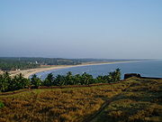
Hosdurg taluk
Encyclopedia

Kasaragod district
Kasaragod District is one of the districts of the Indian state of Kerala. Kasaragod District was organised as a separate district on 24 May 1984...
in the South India
South India
South India is the area encompassing India's states of Andhra Pradesh, Karnataka, Kerala and Tamil Nadu as well as the union territories of Lakshadweep and Pondicherry, occupying 19.31% of India's area...
n state of Kerala
Kerala
or Keralam is an Indian state located on the Malabar coast of south-west India. It was created on 1 November 1956 by the States Reorganisation Act by combining various Malayalam speaking regions....
, the other one being Kasaragod Taluk
Kasaragod taluk
Kasaragod, is a taluk which along with Hosdurg taluk constitute the Kasaragod district, Kerala, India.- External links :* *...
.It shares its borders on north with Kasaragod taluk, south with Kannur District
Kannur district
Kannur District is one of the 14 districts in the state of Kerala, India. The town of Kannur is the district headquarters, and gives the district its name. The old name Cannanore is the anglicised form of the Malayalam name Kannur. Kannur District is bounded by Kasaragod District to the north and...
, east with Dakshina Kannada
Dakshina Kannada
- Geography :The district geography consists of sea shore in the west and Western Ghats in the east. The major rivers are Netravathi, Kumaradhara, Phalguni, Shambhavi, Nandini or Pavanje and Payaswini which all join Arabian sea. Vast areas of evergreen forests which once covered this district, have...
district of Karnataka
Karnataka
Karnataka , the land of the Kannadigas, is a state in South West India. It was created on 1 November 1956, with the passing of the States Reorganisation Act and this day is annually celebrated as Karnataka Rajyotsava...
and on the west with the Arabian sea
Arabian Sea
The Arabian Sea is a region of the Indian Ocean bounded on the east by India, on the north by Pakistan and Iran, on the west by the Arabian Peninsula, on the south, approximately, by a line between Cape Guardafui in northeastern Somalia and Kanyakumari in India...
.With an area of 900.3 km2 (90030 hectares), it is the smaller of the two taluks. It is divided into two Firkas, namely Hosdurg and Nileshwaram.Kanhangad
Kanhangad
Kanhangad is a town and a municipality in Kasaragod district in the Indian state of Kerala. It is 28 km from the district headquarters of Kasaragod. Bekal Fort is a 300-year old fort, one of the largest and best preserved forts in Kerala and lies 10 km north of Kanhangad. The fort is...
and Nileshwaram are the municipalities
Municipality
A municipality is essentially an urban administrative division having corporate status and usually powers of self-government. It can also be used to mean the governing body of a municipality. A municipality is a general-purpose administrative subdivision, as opposed to a special-purpose district...
of the taluk.Hosdurg (after which the taluk is named),a kilometer south of Kanhangad town hosts the taluk office.Other major settlements include Trikarpur
Trikarpur
Trikaripur is a Special Grade Panchayat situated at extreme southern part of Kasaragod District in North Malabar region of the Kerala State, India. This Panchayath consists of two villages viz. South Trikarpur and North Trikarpur...
, Cheruvathur
Cheruvathur
Cheruvathur is a town in the Kasaragod district, located in the South Indian state of Kerala. It is located 58 km from the district headquarters, Kasaragod town.Cheruvathur has a railway station and a small bus stand...
and Chittarikkal
Chittarikkal
Chittarikaal is a village in Kasaragod district in the state of Kerala, India.-History and Etymology:Chitarikaal was a small Hamlet connecting the mountain pathways linking the Thejaswini river jetty at Perumbatta to Cherupuzha and Pulingome, thus forming an important link from the coastal town...
.Bekal Fort is situated in the taluk.
Demographics
As per the 2001 census, Hosdurg taluk had a total population of 449595 persons, which include 217083 males and 232512 females. Hosdurg taluk has a favorable sex ratio.The literacy rate is as high as 85.82%, which is higher than the national average. In Hosdurg taluk, 12.42% of the total population is between the age of 0–6 years.Malayalam is the local and the administrative language of the region.Vellarikund is another major place in hosdurg thaluk

