Howardian Hills
Encyclopedia
The Howardian Hills form an Area of Outstanding Natural Beauty
in North Yorkshire
, England
. located between the Yorkshire Wolds
, the North York Moors National Park and the Vale of York
. The AONB includes farmland, wooded rolling countryside, villages and historic houses with parkland. The hills take their name from the noble Howard family
who owned large areas of the hills.
and York
.The irregular 180 metres (591 ft) ridges of the Howardian Hills are a southern extension of the rocks of the Hambleton Hills
in the North York Moors
. Jurassic
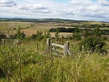
limestone gives the landscape its character. The area contains a rich tapestry of wooded hills and valleys, pastures and rolling farmland, as well as extensive views from the higher ground across the agricultural plains below. On the eastern edge, the River Derwent
cuts through the Hills in the Kirkham Gorge, a deep winding valley which was formed as an overflow channel from glacial Lake Pickering
.
, their appearance suggesting adaptation and reuse of the landscape, over considerable periods of time and possibly serving different functions at different times. Also similar to the Yorkshire Wolds was the identification of square barrow cemeteries which sometimes appeared to be associated with trackways.
and Malton
lie just beyond the boundary. From Brandsby
to Coneysthorpe
is a line of spring line villages. The area has many attractive stone-built, red pantile-roofed buildings. It is the setting for a number of fine country houses, whose parklands are an intrinsic part of the landscape. These grand houses and designed landscapes, such as Castle Howard
, Newburgh Priory
, Hovingham Hall
, Gilling Castle
and Nunnington Hall
, have a dramatic effect upon the scene. The most notable of these is Vanbrugh's famous masterpiece, Castle Howard.
 High grade arable land, pasture and managed woodland makes this rich farming country whose diversity creates its attractive rural character.
Area of Outstanding Natural Beauty
An Area of Outstanding Natural Beauty is an area of countryside considered to have significant landscape value in England, Wales or Northern Ireland, that has been specially designated by the Countryside Agency on behalf of the United Kingdom government; the Countryside Council for Wales on...
in North Yorkshire
North Yorkshire
North Yorkshire is a non-metropolitan or shire county located in the Yorkshire and the Humber region of England, and a ceremonial county primarily in that region but partly in North East England. Created in 1974 by the Local Government Act 1972 it covers an area of , making it the largest...
, England
England
England is a country that is part of the United Kingdom. It shares land borders with Scotland to the north and Wales to the west; the Irish Sea is to the north west, the Celtic Sea to the south west, with the North Sea to the east and the English Channel to the south separating it from continental...
. located between the Yorkshire Wolds
Yorkshire Wolds
The Yorkshire Wolds are low hills in the counties of East Riding of Yorkshire and North Yorkshire in northeastern England. The name also applies to the district in which the hills lie....
, the North York Moors National Park and the Vale of York
Vale of York
The Vale of York is an area of flat land in the north-east of England. The vale is a major agricultural area and serves as the main north-south transport corridor for northern England....
. The AONB includes farmland, wooded rolling countryside, villages and historic houses with parkland. The hills take their name from the noble Howard family
Howard family
The Howard family is an English aristocratic family founded by John Howard who was created Duke of Norfolk by Plantagenet monarch Richard III of England in 1483. However, John was also the eldest grandson of the 1st Duke of 1st creation...
who owned large areas of the hills.
Topography
The Howardian Hills form a roughly rectangular area of well-wooded undulating countryside rising between the flat agricultural Vales of PickeringVale of Pickering
The Vale of Pickering is a low-lying flat area of land in North Yorkshire, England. It is drained by the River Derwent. The landscape is rural with scattered villages and small market towns. It has been inhabited continuously from the Mesolithic period...
and York
Vale of York
The Vale of York is an area of flat land in the north-east of England. The vale is a major agricultural area and serves as the main north-south transport corridor for northern England....
.The irregular 180 metres (591 ft) ridges of the Howardian Hills are a southern extension of the rocks of the Hambleton Hills
Hambleton Hills
The Hambleton Hills are a range of hills in North Yorkshire in the United Kingdom. They form the western edge of the North Yorkshire Moors but are separated from the moors by the valley of the River Rye...
in the North York Moors
North York Moors
The North York Moors is a national park in North Yorkshire, England. The moors are one of the largest expanses of heather moorland in the United Kingdom. It covers an area of , and it has a population of about 25,000...
. Jurassic
Jurassic
The Jurassic is a geologic period and system that extends from about Mya to Mya, that is, from the end of the Triassic to the beginning of the Cretaceous. The Jurassic constitutes the middle period of the Mesozoic era, also known as the age of reptiles. The start of the period is marked by...
limestone gives the landscape its character. The area contains a rich tapestry of wooded hills and valleys, pastures and rolling farmland, as well as extensive views from the higher ground across the agricultural plains below. On the eastern edge, the River Derwent
River Derwent, Yorkshire
The Derwent is a river in Yorkshire in the north of England. It is used for water abstraction, leisure and sporting activities and effluent disposal as well as being of significant importance as the site of several nature reserves...
cuts through the Hills in the Kirkham Gorge, a deep winding valley which was formed as an overflow channel from glacial Lake Pickering
Lake Pickering
Lake Pickering was an extensive proglacial lake of the Devensian glacial. It filled the Vale of Pickering between the North York Moors and the Yorkshire Wolds, when the ice blocked the drainage, which had hitherto flowed north-eastwards past the site of Filey towards the Northern North Sea basin...
.
History
In the spring of 1993 North Yorkshire County Council with the aid of a grant from the Royal Commission on the Historical Monuments of England carried out a field survey of the Howardian Hills to help in its preparation for a Management Plan for the area. Extensive cropmarks of discontinuous parallel ditches were recorded on the dip slope to either side of Barton le Street. Similar features are seen on the Yorkshire WoldsYorkshire Wolds
The Yorkshire Wolds are low hills in the counties of East Riding of Yorkshire and North Yorkshire in northeastern England. The name also applies to the district in which the hills lie....
, their appearance suggesting adaptation and reuse of the landscape, over considerable periods of time and possibly serving different functions at different times. Also similar to the Yorkshire Wolds was the identification of square barrow cemeteries which sometimes appeared to be associated with trackways.
Settlement
The AONB contains no towns, although the market towns of HelmsleyHelmsley
Helmsley is a market town and civil parish in the Ryedale district of North Yorkshire, England. The town is located at the point where the valleys of Bilsdale and Ryedale leave the higher moorland and join the flat Vale of Pickering. It is situated on the River Rye and lies on the A170 road, east...
and Malton
Malton, North Yorkshire
Malton is a market town and civil parish in North Yorkshire, England. The town is the location of the offices of Ryedale District Council and has a population of around 4,000 people....
lie just beyond the boundary. From Brandsby
Brandsby
Brandsby is a village in North Yorkshire, England. The village toponymy is of Danish origin named after a Norseman called Brand....
to Coneysthorpe
Coneysthorpe
Coneysthorpe is a small village and civil parish in the Ryedale district of North Yorkshire, England. It is situated near Castle Howard and 4 miles west of Malton. The Centenary Way long-distance path runs through the village....
is a line of spring line villages. The area has many attractive stone-built, red pantile-roofed buildings. It is the setting for a number of fine country houses, whose parklands are an intrinsic part of the landscape. These grand houses and designed landscapes, such as Castle Howard
Castle Howard
Castle Howard is a stately home in North Yorkshire, England, north of York. One of the grandest private residences in Britain, most of it was built between 1699 and 1712 for the 3rd Earl of Carlisle, to a design by Sir John Vanbrugh...
, Newburgh Priory
Newburgh Priory
Newburgh Priory is a large house near Coxwold, North Yorkshire, England. Standing on the site of an Augustinian priory, founded in 1145, it is a stately home in a rural setting with views to the Kilburn White Horse in the distance...
, Hovingham Hall
Hovingham Hall
Hovingham Hall is a Palladian-style mansion in the village of Hovingham, North Yorkshire, England, the home of the Worsley family and the childhood home of the Duchess of Kent. It was built in the 18th century, and the Worsleys have lived in Hovingham since the 16th century...
, Gilling Castle
Gilling Castle
Gilling Castle is a castle near Gilling East, North Yorkshire, England . The castle was originally the home of the Etton family, who appeared there at the end of the 12th century...
and Nunnington Hall
Nunnington Hall
Nunnington Hall is a country house situated in the English county of North Yorkshire. The river Rye, which gives its name to the local area, Ryedale, runs past the house, flowing away from the village of Nunnington...
, have a dramatic effect upon the scene. The most notable of these is Vanbrugh's famous masterpiece, Castle Howard.
Land use

External links
- Bateman, J. (2006) 'Howardian Hills Field Collection Survey' John Bateman: York Archaeological Survey Report.
- Ampleforth Parish Council Village partly in the Howardian Hills AONB

