
.gif)
Hurricane Easy (1950)
Encyclopedia
Hurricane Easy was the fifth tropical storm, hurricane, and major hurricane of the 1950 Atlantic hurricane season
. The hurricane developed in the western Caribbean Sea on September 1, and tracked northeastward. After crossing Cuba
, the hurricane rapidly strengthened in the eastern Gulf of Mexico
to reach peak winds of 125 mph (205 km/h). Easy executed a cyclonic loop, moved northeastward to hit near Cedar Key, Florida
, executed a second loop, and hit western Florida again. After rapidly weakening over Florida, the hurricane turned to the northwest, and ultimately dissipated over northeastern Arkansas
on September 9. From the point when Hurricane Easy entered the Gulf of Mexico until it weakened to a tropical storm, it was observed nearly constantly from radars or Reconnaissance Aircraft
.
Easy is the most recent major hurricane to strike the Homosassa, Florida
, area. Due to the hurricane remaining near the northwest Florida coast for an extended period of time, Easy produced severe rainfall and strong waves, resulting in heavy damage in the Cedar Key area. Hurricane Easy was one of two major hurricanes to strike Florida during the year; the other was Hurricane King
which affected Miami
.
through the Caribbean Sea
, a trough
of low pressure
persisted across the western Caribbean Sea
. On August 31, convection became more concentrated to the south of the Isle of Youth
, and on September 1 the disturbance developed into a tropical storm; it was later given the name "Easy", as part of the United States Weather Bureau naming
tropical cyclones with the Joint Army/Navy Phonetic Alphabet
. A developing anticyclone
and moist air over the region provided favorable conditions for intensification, as the storm tracked slowly northeastward. On September 2, Tropical Storm Easy attained hurricane status about 50 miles (85 km) south of the Isle of Youth.
After crossing the Isle of Youth, Hurricane Easy strengthened slightly while continuing northeastward, and the storm struck the Matanzas Province
of Cuba
with winds of 80 mph (128.7 km/h). The hurricane quickly crossed the island, passing just east of Havana
before reaching the southeastern Gulf of Mexico
on September 3. After entering the Gulf of Mexico
, Easy turned to the north-northwest, paralleling the Florida
coastline a short distance offshore while producing hurricane force winds onshore. On September 4, the hurricane quickly strengthened to reach peak winds of 125 mph (201.2 km/h), an intensity it would retain for 18 hours. That day, a ridge
of high pressure strengthened to the north of the storm, leaving weaker steering currents. This caused Hurricane Easy to execute a counter-clockwise loop to the west of Tampa, Florida
.
After executing its first loop, Hurricane Easy moved northeastward at 7 mph (11.3 km/h) until making landfall near Cedar Key
on September 5 with winds of 120 mph (193.1 km/h). Steering currents again became weak, causing Easy to execute a second loop in 24 hours towards the southeast. After briefly emerging into the Gulf of Mexico, the hurricane made its final landfall on Homosassa Springs
to the north of Tampa
, and rapidly weakened to a tropical storm over land. Easy turned to the northeast, which was followed by a turn to the northwest as the storm neared the Atlantic
coast. On September 7, Easy crossed into Georgia
, and shortly thereafter it weakened to a tropical depression. The depression continued northwestward for two days until dissipating over extreme northeastern Arkansas
on September 9. The reason for its erratic track, including the two loops, is unknown, although it is potentially due to a Fujiwhara interaction with Hurricane Dog
to its east.
 The hurricane crossed over western Cuba
with winds of up to 80 mph (128.7 km/h); however, damage was minor, and no deaths occurred in the country. In Havana
, winds decreased to 15 mph (24.1 km/h) as the eye of the hurricane crossed over the city.
With an eye
ranging from 18 mi (29 km) to 25 mi (40.2 km) in diameter, the hurricane was well-tracked throughout its lifetime by radars at the University of Florida
and by Reconnaissance Aircraft
. Despite its unusual track, the Weather Bureau issued hurricane warnings
in a timely manner, though warnings were issued for a larger area than those that actually experienced hurricane force winds. In the Florida Keys
, winds from Easy reached 72 mph (115.9 km/h), which downed trees and power lines, littering local streets with debris. Heavy seas moved around a Navy barge, though no damage was reported.
Hurricane Easy produced hurricane force winds across large portions of western Florida
, including over 100 mph (160.9 km/h) winds in Cedar Key
for 9 and 1/2 hours. The town, which reported a minimum pressure of 958.3 mbar
(28.30 in), experienced the eye of the hurricane for 2 and 1/2 hours while strong waves hit the coast. The tide in Tampa Bay
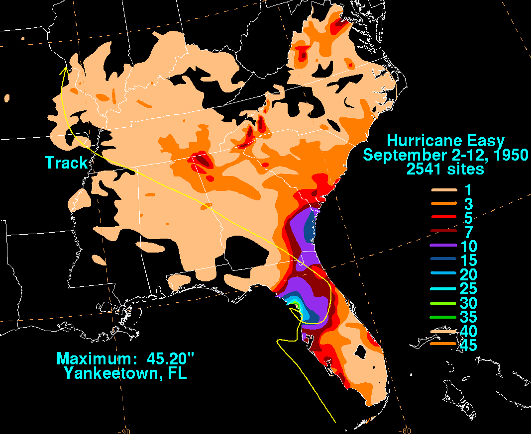
rose 6.5 ft (2 m), the highest since 1921. While looping twice along its path, the hurricane dropped heavy amounts of rainfall of 10 in (254 mm) to 20 in (508 mm) in large portions of northwestern Florida
. Rainfall totals include 24.5 in (622.3 mm) in Cedar Key in 3 days and 38.7 in (983 mm) in Yankeetown, Florida
in 24 hours, which became the largest 24 hour rainfall total on record for the United States
. The record has since been broken by Tropical Storm Claudette
in 1979 with 43 in (1,092.2 mm), though Easy's total remains the largest 24 hour rainfall total on record for the state of Florida.
Hurricane Easy was described as the worst hurricane in the Cedar Key area in 70 years. The hurricane left half of the houses destroyed or unfit for rehabilitation, while 90% of the others were damaged. The strong winds destroyed the roofs of 150 homes and buildings. The rainfall caused severe flooding that resulted in crop damage. Easy was indirectly responsible for two deaths due to electrocutions. In addition, 27 people were injured from the hurricane. The strong waves destroyed the fishing community's entire fishing fleet of 100 boats, which was the town's entire livelihood. The town's main employment center, a broom and brush plant, was severely damaged, and would close two years after the hurricane. The hurricane also produced severe damage in Pinellas
and Hillsborough Counties
in the Tampa
area. Throughout Florida, damages totaled $3.3 million (1950 USD), a lower than expected total due to the sparse population in the area of the worst damage. After the storm's passage throughout central and northern Florida, "blisters" developed on hundreds of cars; the locations affected reported that the blisters formed on the surface of vehicles shortly after Easy retreated. The following day, the blisters disappeared. Researchers later created several theories as to the unusual occurrence, though they concluded that air pockets under the layer of paint expanded as a result of the decreased barometric pressure.
1950 Atlantic hurricane season
The 1950 Atlantic hurricane season was the first year in which tropical cyclones were given official names in the Atlantic basin. Names were taken from the Joint Army/Navy Phonetic Alphabet, with the first named storm being designated "Able", the second "Baker", and so on. It was an active season...
. The hurricane developed in the western Caribbean Sea on September 1, and tracked northeastward. After crossing Cuba
Cuba
The Republic of Cuba is an island nation in the Caribbean. The nation of Cuba consists of the main island of Cuba, the Isla de la Juventud, and several archipelagos. Havana is the largest city in Cuba and the country's capital. Santiago de Cuba is the second largest city...
, the hurricane rapidly strengthened in the eastern Gulf of Mexico
Gulf of Mexico
The Gulf of Mexico is a partially landlocked ocean basin largely surrounded by the North American continent and the island of Cuba. It is bounded on the northeast, north and northwest by the Gulf Coast of the United States, on the southwest and south by Mexico, and on the southeast by Cuba. In...
to reach peak winds of 125 mph (205 km/h). Easy executed a cyclonic loop, moved northeastward to hit near Cedar Key, Florida
Cedar Key, Florida
Cedar Key is a city in Levy County, Florida, United States. The population was 790 at the 2000 census. According to the U.S Census estimates of 2005, the city had a population of 958. The Cedar Keys are a cluster of islands close to the mainland. Most of the developed area of the city has been on...
, executed a second loop, and hit western Florida again. After rapidly weakening over Florida, the hurricane turned to the northwest, and ultimately dissipated over northeastern Arkansas
Arkansas
Arkansas is a state located in the southern region of the United States. Its name is an Algonquian name of the Quapaw Indians. Arkansas shares borders with six states , and its eastern border is largely defined by the Mississippi River...
on September 9. From the point when Hurricane Easy entered the Gulf of Mexico until it weakened to a tropical storm, it was observed nearly constantly from radars or Reconnaissance Aircraft
Reconnaissance aircraft
A reconnaissance aircraft is a manned military aircraft designed, or adapted, to carry out aerial reconnaissance.-History:The majority of World War I aircraft were reconnaissance designs...
.
Easy is the most recent major hurricane to strike the Homosassa, Florida
Homosassa, Florida
Homosassa is a census-designated place in Citrus County, Florida, United States. The population was 2,294 at the 2000 census.-Historic:...
, area. Due to the hurricane remaining near the northwest Florida coast for an extended period of time, Easy produced severe rainfall and strong waves, resulting in heavy damage in the Cedar Key area. Hurricane Easy was one of two major hurricanes to strike Florida during the year; the other was Hurricane King
Hurricane King
Hurricane King was the most severe hurricane to strike Florida since the 1926 Miami hurricane. It was the eleventh tropical storm and the last of a record-setting eight major hurricanes in the 1950 Atlantic hurricane season. The cyclone formed in the western Caribbean Sea on October 13, and...
which affected Miami
Miami, Florida
Miami is a city located on the Atlantic coast in southeastern Florida and the county seat of Miami-Dade County, the most populous county in Florida and the eighth-most populous county in the United States with a population of 2,500,625...
.
Meteorological history
Following the passage of Hurricane BakerHurricane Baker (1950)
Hurricane Baker was a major hurricane that affected the Leeward Islands, Greater Antilles, and the Gulf Coast of the United States. The tropical cyclone was the second intense hurricane, second hurricane, and second tropical storm of the 1950 Atlantic hurricane season...
through the Caribbean Sea
Caribbean Sea
The Caribbean Sea is a sea of the Atlantic Ocean located in the tropics of the Western hemisphere. It is bounded by Mexico and Central America to the west and southwest, to the north by the Greater Antilles, and to the east by the Lesser Antilles....
, a trough
Trough (meteorology)
A trough is an elongated region of relatively low atmospheric pressure, often associated with fronts.Unlike fronts, there is not a universal symbol for a trough on a weather chart. The weather charts in some countries or regions mark troughs by a line. In the United States, a trough may be marked...
of low pressure
Low pressure area
A low-pressure area, or "low", is a region where the atmospheric pressure at sea level is below that of surrounding locations. Low-pressure systems form under areas of wind divergence which occur in upper levels of the troposphere. The formation process of a low-pressure area is known as...
persisted across the western Caribbean Sea
Caribbean Sea
The Caribbean Sea is a sea of the Atlantic Ocean located in the tropics of the Western hemisphere. It is bounded by Mexico and Central America to the west and southwest, to the north by the Greater Antilles, and to the east by the Lesser Antilles....
. On August 31, convection became more concentrated to the south of the Isle of Youth
Isle of Youth
Isla de la Juventud is the second-largest Cuban island and the seventh-largest island in the West Indies . The island has an area and is 100 km south of the island of Cuba, across the Gulf of Batabanó...
, and on September 1 the disturbance developed into a tropical storm; it was later given the name "Easy", as part of the United States Weather Bureau naming
Tropical cyclone naming
Tropical cyclones have officially been named since 1945 and are named for a variety of reasons, which include to facilitate communications between forecasters and the public when forecasts, watches, and warnings are issued. Names also reduce confusion about what storm is being described, as more...
tropical cyclones with the Joint Army/Navy Phonetic Alphabet
Joint Army/Navy Phonetic Alphabet
The Joint Army/Navy Phonetic Alphabet was a radio alphabet developed in 1941 and was used by all branches of the United States military until the promulgation of the ICAO spelling alphabet in 1956, which replaced it...
. A developing anticyclone
Anticyclone
An anticyclone is a weather phenomenon defined by the United States' National Weather Service's glossary as "[a] large-scale circulation of winds around a central region of high atmospheric pressure, clockwise in the Northern Hemisphere, counterclockwise in the Southern Hemisphere"...
and moist air over the region provided favorable conditions for intensification, as the storm tracked slowly northeastward. On September 2, Tropical Storm Easy attained hurricane status about 50 miles (85 km) south of the Isle of Youth.
After crossing the Isle of Youth, Hurricane Easy strengthened slightly while continuing northeastward, and the storm struck the Matanzas Province
Matanzas Province
Matanzas is one of the provinces of Cuba. Major towns in the province include Cárdenas, Colón, Jovellanos and the capital of the same name, Matanzas...
of Cuba
Cuba
The Republic of Cuba is an island nation in the Caribbean. The nation of Cuba consists of the main island of Cuba, the Isla de la Juventud, and several archipelagos. Havana is the largest city in Cuba and the country's capital. Santiago de Cuba is the second largest city...
with winds of 80 mph (128.7 km/h). The hurricane quickly crossed the island, passing just east of Havana
Havana
Havana is the capital city, province, major port, and leading commercial centre of Cuba. The city proper has a population of 2.1 million inhabitants, and it spans a total of — making it the largest city in the Caribbean region, and the most populous...
before reaching the southeastern Gulf of Mexico
Gulf of Mexico
The Gulf of Mexico is a partially landlocked ocean basin largely surrounded by the North American continent and the island of Cuba. It is bounded on the northeast, north and northwest by the Gulf Coast of the United States, on the southwest and south by Mexico, and on the southeast by Cuba. In...
on September 3. After entering the Gulf of Mexico
Gulf of Mexico
The Gulf of Mexico is a partially landlocked ocean basin largely surrounded by the North American continent and the island of Cuba. It is bounded on the northeast, north and northwest by the Gulf Coast of the United States, on the southwest and south by Mexico, and on the southeast by Cuba. In...
, Easy turned to the north-northwest, paralleling the Florida
Florida
Florida is a state in the southeastern United States, located on the nation's Atlantic and Gulf coasts. It is bordered to the west by the Gulf of Mexico, to the north by Alabama and Georgia and to the east by the Atlantic Ocean. With a population of 18,801,310 as measured by the 2010 census, it...
coastline a short distance offshore while producing hurricane force winds onshore. On September 4, the hurricane quickly strengthened to reach peak winds of 125 mph (201.2 km/h), an intensity it would retain for 18 hours. That day, a ridge
Ridge (meteorology)
A ridge is an elongated region of relatively high atmospheric pressure, the opposite of a trough....
of high pressure strengthened to the north of the storm, leaving weaker steering currents. This caused Hurricane Easy to execute a counter-clockwise loop to the west of Tampa, Florida
Tampa, Florida
Tampa is a city in the U.S. state of Florida. It serves as the county seat for Hillsborough County. Tampa is located on the west coast of Florida. The population of Tampa in 2010 was 335,709....
.
After executing its first loop, Hurricane Easy moved northeastward at 7 mph (11.3 km/h) until making landfall near Cedar Key
Cedar Key, Florida
Cedar Key is a city in Levy County, Florida, United States. The population was 790 at the 2000 census. According to the U.S Census estimates of 2005, the city had a population of 958. The Cedar Keys are a cluster of islands close to the mainland. Most of the developed area of the city has been on...
on September 5 with winds of 120 mph (193.1 km/h). Steering currents again became weak, causing Easy to execute a second loop in 24 hours towards the southeast. After briefly emerging into the Gulf of Mexico, the hurricane made its final landfall on Homosassa Springs
Homosassa Springs, Florida
Homosassa Springs is a census-designated place in Citrus County, Florida, United States. The population was 12,458 at the 2000 census.The name derives from the warm spring located in the Wildlife State Park that attracts manatees to the area....
to the north of Tampa
Tampa, Florida
Tampa is a city in the U.S. state of Florida. It serves as the county seat for Hillsborough County. Tampa is located on the west coast of Florida. The population of Tampa in 2010 was 335,709....
, and rapidly weakened to a tropical storm over land. Easy turned to the northeast, which was followed by a turn to the northwest as the storm neared the Atlantic
Atlantic Ocean
The Atlantic Ocean is the second-largest of the world's oceanic divisions. With a total area of about , it covers approximately 20% of the Earth's surface and about 26% of its water surface area...
coast. On September 7, Easy crossed into Georgia
Georgia (U.S. state)
Georgia is a state located in the southeastern United States. It was established in 1732, the last of the original Thirteen Colonies. The state is named after King George II of Great Britain. Georgia was the fourth state to ratify the United States Constitution, on January 2, 1788...
, and shortly thereafter it weakened to a tropical depression. The depression continued northwestward for two days until dissipating over extreme northeastern Arkansas
Arkansas
Arkansas is a state located in the southern region of the United States. Its name is an Algonquian name of the Quapaw Indians. Arkansas shares borders with six states , and its eastern border is largely defined by the Mississippi River...
on September 9. The reason for its erratic track, including the two loops, is unknown, although it is potentially due to a Fujiwhara interaction with Hurricane Dog
Hurricane Dog (1950)
Hurricane Dog was the most intense hurricane in the 1950 Atlantic hurricane season. The fourth named storm of the season, Dog developed on August 30 to the east of Antigua; after passing through the northern Lesser Antilles, it turned to the north and intensified into a Category 5 hurricane...
to its east.
Preparations and impact
Cuba
The Republic of Cuba is an island nation in the Caribbean. The nation of Cuba consists of the main island of Cuba, the Isla de la Juventud, and several archipelagos. Havana is the largest city in Cuba and the country's capital. Santiago de Cuba is the second largest city...
with winds of up to 80 mph (128.7 km/h); however, damage was minor, and no deaths occurred in the country. In Havana
Havana
Havana is the capital city, province, major port, and leading commercial centre of Cuba. The city proper has a population of 2.1 million inhabitants, and it spans a total of — making it the largest city in the Caribbean region, and the most populous...
, winds decreased to 15 mph (24.1 km/h) as the eye of the hurricane crossed over the city.
With an eye
Eye (cyclone)
The eye is a region of mostly calm weather found at the center of strong tropical cyclones. The eye of a storm is a roughly circular area and typically 30–65 km in diameter. It is surrounded by the eyewall, a ring of towering thunderstorms where the second most severe weather of a cyclone...
ranging from 18 mi (29 km) to 25 mi (40.2 km) in diameter, the hurricane was well-tracked throughout its lifetime by radars at the University of Florida
University of Florida
The University of Florida is an American public land-grant, sea-grant, and space-grant research university located on a campus in Gainesville, Florida. The university traces its historical origins to 1853, and has operated continuously on its present Gainesville campus since September 1906...
and by Reconnaissance Aircraft
Reconnaissance aircraft
A reconnaissance aircraft is a manned military aircraft designed, or adapted, to carry out aerial reconnaissance.-History:The majority of World War I aircraft were reconnaissance designs...
. Despite its unusual track, the Weather Bureau issued hurricane warnings
Tropical cyclone warnings and watches
Warnings and watches are two levels of alert issued by national weather forecasting bodies to coastal areas threatened by the imminent approach of a tropical cyclone of tropical storm or hurricane intensity. They are notices to the local population and civil authorities to make appropriate...
in a timely manner, though warnings were issued for a larger area than those that actually experienced hurricane force winds. In the Florida Keys
Florida Keys
The Florida Keys are a coral archipelago in southeast United States. They begin at the southeastern tip of the Florida peninsula, about south of Miami, and extend in a gentle arc south-southwest and then westward to Key West, the westernmost of the inhabited islands, and on to the uninhabited Dry...
, winds from Easy reached 72 mph (115.9 km/h), which downed trees and power lines, littering local streets with debris. Heavy seas moved around a Navy barge, though no damage was reported.
Hurricane Easy produced hurricane force winds across large portions of western Florida
Florida
Florida is a state in the southeastern United States, located on the nation's Atlantic and Gulf coasts. It is bordered to the west by the Gulf of Mexico, to the north by Alabama and Georgia and to the east by the Atlantic Ocean. With a population of 18,801,310 as measured by the 2010 census, it...
, including over 100 mph (160.9 km/h) winds in Cedar Key
Cedar Key, Florida
Cedar Key is a city in Levy County, Florida, United States. The population was 790 at the 2000 census. According to the U.S Census estimates of 2005, the city had a population of 958. The Cedar Keys are a cluster of islands close to the mainland. Most of the developed area of the city has been on...
for 9 and 1/2 hours. The town, which reported a minimum pressure of 958.3 mbar
Bar (unit)
The bar is a unit of pressure equal to 100 kilopascals, and roughly equal to the atmospheric pressure on Earth at sea level. Other units derived from the bar are the megabar , kilobar , decibar , centibar , and millibar...
(28.30 in), experienced the eye of the hurricane for 2 and 1/2 hours while strong waves hit the coast. The tide in Tampa Bay
Tampa Bay
Tampa Bay is a large natural harbor and estuary along the Gulf of Mexico on the west central coast of Florida, comprising Hillsborough Bay, Old Tampa Bay, Middle Tampa Bay, and Lower Tampa Bay."Tampa Bay" is not the name of any municipality...
rose 6.5 ft (2 m), the highest since 1921. While looping twice along its path, the hurricane dropped heavy amounts of rainfall of 10 in (254 mm) to 20 in (508 mm) in large portions of northwestern Florida
Florida
Florida is a state in the southeastern United States, located on the nation's Atlantic and Gulf coasts. It is bordered to the west by the Gulf of Mexico, to the north by Alabama and Georgia and to the east by the Atlantic Ocean. With a population of 18,801,310 as measured by the 2010 census, it...
. Rainfall totals include 24.5 in (622.3 mm) in Cedar Key in 3 days and 38.7 in (983 mm) in Yankeetown, Florida
Yankeetown, Florida
Yankeetown is a town in Levy County, Florida, United States. The population was 629 at the 2000 census. According to the U.S. Census Bureau's 2004 estimates, the town had a population of 672.-History:...
in 24 hours, which became the largest 24 hour rainfall total on record for the United States
United States
The United States of America is a federal constitutional republic comprising fifty states and a federal district...
. The record has since been broken by Tropical Storm Claudette
Tropical Storm Claudette (1979)
Tropical Storm Claudette was a long living tropical storm that produced heavy rain across Puerto Rico and Texas in late July 1979. The storm killed 2 people and left $1.1 billion in damage...
in 1979 with 43 in (1,092.2 mm), though Easy's total remains the largest 24 hour rainfall total on record for the state of Florida.
Hurricane Easy was described as the worst hurricane in the Cedar Key area in 70 years. The hurricane left half of the houses destroyed or unfit for rehabilitation, while 90% of the others were damaged. The strong winds destroyed the roofs of 150 homes and buildings. The rainfall caused severe flooding that resulted in crop damage. Easy was indirectly responsible for two deaths due to electrocutions. In addition, 27 people were injured from the hurricane. The strong waves destroyed the fishing community's entire fishing fleet of 100 boats, which was the town's entire livelihood. The town's main employment center, a broom and brush plant, was severely damaged, and would close two years after the hurricane. The hurricane also produced severe damage in Pinellas
Pinellas County, Florida
Pinellas County is a county located in the state of Florida. Its county seat is Clearwater, Florida, and its largest city is St. Petersburg. This county is contained entirely within the telephone area code 727, except for some sections of Oldsmar, which have the area code 813...
and Hillsborough Counties
Hillsborough County, Florida
As of the census of 2000, there were 998,948 people, 391,357 households, and 255,164 families residing in the county. The population density was 951 people per square mile . There were 425,962 housing units at an average density of 405 per square mile...
in the Tampa
Tampa, Florida
Tampa is a city in the U.S. state of Florida. It serves as the county seat for Hillsborough County. Tampa is located on the west coast of Florida. The population of Tampa in 2010 was 335,709....
area. Throughout Florida, damages totaled $3.3 million (1950 USD), a lower than expected total due to the sparse population in the area of the worst damage. After the storm's passage throughout central and northern Florida, "blisters" developed on hundreds of cars; the locations affected reported that the blisters formed on the surface of vehicles shortly after Easy retreated. The following day, the blisters disappeared. Researchers later created several theories as to the unusual occurrence, though they concluded that air pockets under the layer of paint expanded as a result of the decreased barometric pressure.
See also
- Other storms of the same nameHurricane Easy (disambiguation)There have been several hurricanes designated Easy when the initial naming system was used .* 1950's Hurricane Easy - made landfall in Florida as a Category 3 hurricane; caused heavy damage in Cedar Key and produced heavy rainfall* 1951's Hurricane Easy - category 5 hurricane that never...
- List of wettest tropical cyclones in the United States
- List of Florida hurricanes (1950-1974)