

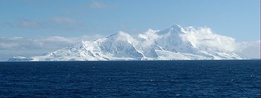
Imeon Range
Encyclopedia
Mountain range
A mountain range is a single, large mass consisting of a succession of mountains or narrowly spaced mountain ridges, with or without peaks, closely related in position, direction, formation, and age; a component part of a mountain system or of a mountain chain...
occupying the interior of Smith Island
Smith Island (South Shetland Islands)
Smith Island is long and wide, lying west of Deception Island in the South Shetland Islands of the British Antarctic Territory. Surface area ....
in the South Shetland Islands
South Shetland Islands
The South Shetland Islands are a group of Antarctic islands, lying about north of the Antarctic Peninsula, with a total area of . By the Antarctic Treaty of 1959, the Islands' sovereignty is neither recognized nor disputed by the signatories and they are free for use by any signatory for...
, Antarctica. Extending 30 km in southwest-northeast direction between Cape James and Cape Smith, and 6.8 km wide. Its summit Mount Foster
Mount Foster
Mount Foster is a peak rising to 2105 m in the Imeon Range on Smith Island in the South Shetland Islands, Antarctica. It is the highest point of the South Shetland Islands archipelago....
– summit of the South Shetlands archipelago too – is a double peak, the higher south height of which (2105 m) was first climbed on January 30, 1996 by a New Zealand
New Zealand
New Zealand is an island country in the south-western Pacific Ocean comprising two main landmasses and numerous smaller islands. The country is situated some east of Australia across the Tasman Sea, and roughly south of the Pacific island nations of New Caledonia, Fiji, and Tonga...
team led by Greg Landreth. Other prominent peaks include Evlogi Peak
Evlogi Peak
Evlogi Peak is a peak rising to 2090 m in Imeon Range on Smith Island, South Shetland Islands. Situated 1 km north-northeast of the summit Mount Foster, and 1.3 km southwest of Antim Peak, with intervening saddles of elevation 1950 and 1800 m respectively...
(2090 m), Antim Peak
Antim Peak
Antim Peak is the ice-covered peak rising to 2080 m in Imeon Range on Smith Island in the South Shetland Islands, Antarctica. Situated 2.25nbsp;km and 1.3 km northeast of the summit Mount Foster and Evlogi Peak respectively, 5.4 km south-southwest of Mount Pisgah, 16 km...
(2080 m), Mount Pisgah
Mount Pisgah (Smith Island)
Mount Pisgah is a peak rising to 1860 m in the north-central part of Imeon Range on Smith Island in the South Shetland Islands, Antarctica. It is linked by Kostenets Saddle to Drinov Peak to the southwest, and surmounts Dalgopol Glacier to the north and Vetrino Glacier to the west.Because the...
(1860 m), Slaveykov Peak
Slaveykov Peak
Slaveykov Peak is the sharp peak rising to 1760 m in Imeon Range on Smith Island in the South Shetland Islands, Antarctica. The feature is situated 2 km southwest of the summit Mount Foster, to which it is linked by Zavet Saddle, 1.12 km north-northeast of Neofit Peak, 2.4 km...
(1760 m), Neofit Peak
Neofit Peak
Neofit Peak is an ice-covered peak rising to 1750 m in Imeon Range on Smith Island in the South Shetland Islands, Antarctica. Situated 1.12 km south-southwest of Slaveykov Peak, 3.1 km southwest of the summit Mount Foster, 2.38 km northeast of Riggs Peak and 10.98 km northeast...
(1750 m), Drinov Peak
Drinov Peak
Drinov Peak is a peak rising to 1630 m in Imeon Range on Smith Island, South Shetland Islands. Situated 3.6 km north-northeast of Antim Peak, 1.9 km north of Slatina Peak, 2.91 km east-southeast of Jireček Point and 1.85 km southwest of Mount Pisgah...
(1630 m), Riggs Peak
Riggs Peak
Riggs Peak is a peak rising to 1690 m in Imeon Range on Smith Island, South Shetland Islands. Situated 2.38 km southwest of Neofit Peak, 5.4 km southwest of the summit Mount Foster, and 8.6 km northeast of Cape James. Overlooking Letnitsa Glacier to the south, and Gramada Glacier...
(1690 m) and Mount Christi (1280 m).
The range is named after Mount Imeon
Mount Imeon
Mount Imeon is an ancient name for the Central Asian complex of mountain ranges comprising the present Hindu Kush, Pamir and Tian Shan, extending from the Zagros Mountains in the southwest to the Altay Mountains in the northeast, and linked to the Kunlun, Karakoram and Himalayas to the southeast...
(present day Pamir
Pamir Mountains
The Pamir Mountains are a mountain range in Central Asia formed by the junction or knot of the Himalayas, Tian Shan, Karakoram, Kunlun, and Hindu Kush ranges. They are among the world’s highest mountains and since Victorian times they have been known as the "Roof of the World" a probable...
, Hindu Kush
Hindu Kush
The Hindu Kush is an mountain range that stretches between central Afghanistan and northern Pakistan. The highest point in the Hindu Kush is Tirich Mir in the Chitral region of Khyber-Pakhtunkhwa, Pakistan.It is the westernmost extension of the Pamir Mountains, the Karakoram Range, and is a...
, and Tian Shan
Tian Shan
The Tian Shan , also spelled Tien Shan, is a large mountain system located in Central Asia. The highest peak in the Tian Shan is Victory Peak , ....
), whose highlands and valleys around upper Oxus River (Amu Darya
Amu Darya
The Amu Darya , also called Oxus and Amu River, is a major river in Central Asia. It is formed by the junction of the Vakhsh and Panj rivers...
) were the ancient homeland of Bulgars
Bulgars
The Bulgars were a semi-nomadic who flourished in the Pontic Steppe and the Volga basin in the 7th century.The Bulgars emerge after the collapse of the Hunnic Empire in the 5th century....
as described in the seventh century Armenia
Armenia
Armenia , officially the Republic of Armenia , is a landlocked mountainous country in the Caucasus region of Eurasia...
n geography index ‘Ashharatsuyts’ by Anania Shirakatsi
Anania Shirakatsi
Anania Shirakatsi was an Armenian mathematician, astronomer and geographer. He is commonly attributed to having written the Geography .-Life:Scholars are split on where exactly Anania was born...
.
See also
- Smith IslandSmith Island (South Shetland Islands)Smith Island is long and wide, lying west of Deception Island in the South Shetland Islands of the British Antarctic Territory. Surface area ....
- List of Bulgarian toponyms in Antarctica
Map
- L.L. Ivanov. Antarctica: Livingston Island and Greenwich, Robert, Snow and Smith Islands. Scale 1:120000 topographic map. Troyan: Manfred Wörner Foundation, 2009. ISBN 978-954-92032-6-4