Interstate 189
Encyclopedia
Interstate 189 is an auxiliary Interstate Highway in Chittenden County, Vermont
, United States
. The highway extends for 1.488 miles (2.4 km) from Interstate 89 exit 13 in South Burlington
to U.S. Route 7 just inside the Burlington
city limits. I-189 is the only spur on the entire length of I-89.
I-189 serves as an Interstate-grade connector between I-89 and a commercial district along US 7 (Shelburne Road). It is signed as an east–west highway. Prior to 2010, only one directional sign had been posted on the highway - on the eastbound side after the on-ramp from US 7. Sign replacements and additions in late 2010 added directional signs on both the eastbound and westbound sides of the route.
s are in place directing traffic on I-189 east onto the US 7 off-ramp, while there is much unused roadway to the west.

. All exits are unnumbered.
Chittenden County, Vermont
Chittenden County is a county located in the U.S. state of Vermont. As of 2010, the population was 156,545. Its shire town is Burlington. Chittenden is the most populous county in the state, with more than twice as many residents as Vermont's second-most populous county, Rutland.Chittenden County...
, United States
United States
The United States of America is a federal constitutional republic comprising fifty states and a federal district...
. The highway extends for 1.488 miles (2.4 km) from Interstate 89 exit 13 in South Burlington
South Burlington, Vermont
-Economy:CommutAir, a regional airline, is headquartered in the city, by the airport. The Magic Hat Brewing Company, one of the United States's larger craft breweries, is located here.One measure of economic activity is retail sales...
to U.S. Route 7 just inside the Burlington
Burlington, Vermont
Burlington is the largest city in the U.S. state of Vermont and the shire town of Chittenden County. Burlington lies south of the U.S.-Canadian border and some south of Montreal....
city limits. I-189 is the only spur on the entire length of I-89.
I-189 serves as an Interstate-grade connector between I-89 and a commercial district along US 7 (Shelburne Road). It is signed as an east–west highway. Prior to 2010, only one directional sign had been posted on the highway - on the eastbound side after the on-ramp from US 7. Sign replacements and additions in late 2010 added directional signs on both the eastbound and westbound sides of the route.
History
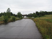
There were at one time more plans for the highway. It was to continue north into the city of Burlington along the waterfront and service an industrial area. Construction was delayed due to the presence of a toxic barge canal and eventually cancelled as the city largely left behind its industrial past in favor of tourism in the 1980s. Roadway was abandoned just beyond the US 7 interchange. As a result, Jersey barrierJersey barrier
A Jersey barrier or Jersey wall is a modular concrete barrier employed to separate lanes of traffic. It is designed to both minimize vehicle damage in cases of incidental contact while still preventing crossover in the case of head-on accidents....
s are in place directing traffic on I-189 east onto the US 7 off-ramp, while there is much unused roadway to the west.

Future
The Federal Government recently gave the state a deadline to make a final decision on building the extension or they would lose matching funds. At this point consensus is for a two-lane parkway that will curve northerly onto existing city streets in order to funnel traffic into downtown away from U.S. 7. The proposed name for this road would be the "Champlain Parkway".Exit list
The entire route is in Chittenden CountyChittenden County, Vermont
Chittenden County is a county located in the U.S. state of Vermont. As of 2010, the population was 156,545. Its shire town is Burlington. Chittenden is the most populous county in the state, with more than twice as many residents as Vermont's second-most populous county, Rutland.Chittenden County...
. All exits are unnumbered.
| Location | Mile | Destinations | Notes |
|---|---|---|---|
| Burlington Burlington, Vermont Burlington is the largest city in the U.S. state of Vermont and the shire town of Chittenden County. Burlington lies south of the U.S.-Canadian border and some south of Montreal.... |
0.000 | , Rutland, Middlebury | Westbound exit and eastbound entrance |
| South Burlington South Burlington, Vermont -Economy:CommutAir, a regional airline, is headquartered in the city, by the airport. The Magic Hat Brewing Company, one of the United States's larger craft breweries, is located here.One measure of economic activity is retail sales... |
1.488 | , St. Albans St. Albans (city), Vermont St. Albans is a city in and the shire town of Franklin County, Vermont, in the United States. At the 2000 census, the city population was 7,650. St Albans City is completely surrounded by St. Albans town, which is incorporated separately from the city of St. Albans... |
Eastbound exit and westbound entrance |
| Dorset Street – Burlington International Airport Burlington International Airport Burlington International Airport is a joint-use public and military airport in Chittenden County, Vermont, United States. It is owned by the City of Burlington... |
At-grade intersection At-grade intersection An at-grade intersection is a junction at which two or more transport axes cross at the same level .-Traffic management:With areas of high or fast traffic, an at-grade intersection normally requires a traffic control device such as a stop sign, traffic light or railway signal to manage conflicting... |

