Irrigation statistics
Encyclopedia
This page shows statistical
data on irrigation
of agricultural lands world wide.
Irrigation is the artificial abstraction of water from a source followed by the distribution of it at scheme level aiming at application at field level to enhance crop production when rainfall is scarce.
Only the countries with more than 10 million ha of irrigated land are mentioned.
(*) Including India, China and Pakistan
There are 4 countries with 5 to 10 million ha irrigated land: Iran
(7.7), Mexico
(6.3), Turkey
(5.1), and Thailand
(5.0).
The 16 countries with 2 to 5 million ha irrigated land are: Bangladesh
(4.7), Indonesia
(4.5), Russia
(4.5), Uzbekistan
(4.3), Spain
(3.8), Brazil
(3.5), Iraq
(3.5), Egypt
(3.4), Rumania (3.0), Vietnam
(3.0), Italy
(2.8), France
(2.6), Japan
(2.6), Australia
(2.6), Ukraine
(2.3), and Kazakhstan
(2.1)
, whereby the water is spread over the field by gravity.
Of the remaining 6%, the majority is irrigated by methods requiring energy
, expensive hydraulic pressure techniques and pipe systems like sprinkler irrigation and drip irrigation
, for the major part in the USA. The source of irrigation water in these cases often is groundwater
from aquifer
s. However, the exploitation of aquifers can also be combined with surface irrigation at field level.


 In relatively small areas one applies subirrigation
whereby the water infiltrates into the soil below the soil surface from pipes or ditches. This category includes tidal irrigation
used in the lower part of rivers where the tidal influence
is felt by permitting the river water to enter ditches at high tide and allowing it to infiltrate from there into the soil
In relative rare cases one uses labor-intensive methods like irrigation with watering-cans and by filling dug-in porous pots (pitcher irrigation) from where the water enters the soil by capillary
suction.
Surface irrigation can be divided into the following types, based on the method by which water is spread over the field after it has been admitted through the inlet:
The first four forms of irrigation come in the category of flood-irrigation, because the entire surface of the cropped area is wetted, whereas with furrow irrigation, the surface of the ridges remain dry.
The irrigation of sloping fields is called flow irrigation as the water on the surface does not come to a stand still and the stream entering the field has to be cut back before the wetting front reaches the end of the field to avoid runoff losses.
The following table shows the irrigation development in the world between 1955 to 1983, distinguishing developed from developing countries:
The developed countries witnessed a relatively greater increase than the developing nations.
The water used for irrigation is roughly 25% of the annually available water resources (14 000 km3) and 9 % of all annual river discharges in the hydrological cycle.
River discharges occur for the major part in regions with humid climates, far removed from the regions with (semi)arid climates, where irrigation water is most needed. Compared to the 8 600 km3 of annual river discharge in the drier climates only, the yearly water use for irrigation is 40%
Of the total irrigated area worldwide 38% is equipped for irrigation with groundwater, especially in India (39 million ha), China (19 million ha) and the United States of America (17 million ha). Total consumptive groundwater use for irrigation is estimated as 545 km3/year. Groundwater use in irrigation leads in places to exploitation of groundwater at rates above groundwater recharge and depletion of groundwater reservoirs.
Statistics
Statistics is the study of the collection, organization, analysis, and interpretation of data. It deals with all aspects of this, including the planning of data collection in terms of the design of surveys and experiments....
data on irrigation
Irrigation
Irrigation may be defined as the science of artificial application of water to the land or soil. It is used to assist in the growing of agricultural crops, maintenance of landscapes, and revegetation of disturbed soils in dry areas and during periods of inadequate rainfall...
of agricultural lands world wide.
Irrigation is the artificial abstraction of water from a source followed by the distribution of it at scheme level aiming at application at field level to enhance crop production when rainfall is scarce.
Irrigated area
The next table gives an overview of irrigated areas in the world in 2003Only the countries with more than 10 million ha of irrigated land are mentioned.
| Area (106 ha) | |
| India India India , officially the Republic of India , is a country in South Asia. It is the seventh-largest country by geographical area, the second-most populous country with over 1.2 billion people, and the most populous democracy in the world... |
57 |
| China China Chinese civilization may refer to:* China for more general discussion of the country.* Chinese culture* Greater China, the transnational community of ethnic Chinese.* History of China* Sinosphere, the area historically affected by Chinese culture... |
54 |
| Pakistan Pakistan Pakistan , officially the Islamic Republic of Pakistan is a sovereign state in South Asia. It has a coastline along the Arabian Sea and the Gulf of Oman in the south and is bordered by Afghanistan and Iran in the west, India in the east and China in the far northeast. In the north, Tajikistan... |
19 |
| Asia Asia Asia is the world's largest and most populous continent, located primarily in the eastern and northern hemispheres. It covers 8.7% of the Earth's total surface area and with approximately 3.879 billion people, it hosts 60% of the world's current human population... (*) |
188 |
| USA | 22 |
| World World World is a common name for the whole of human civilization, specifically human experience, history, or the human condition in general, worldwide, i.e. anywhere on Earth.... |
277 |
(*) Including India, China and Pakistan
There are 4 countries with 5 to 10 million ha irrigated land: Iran
Iran
Iran , officially the Islamic Republic of Iran , is a country in Southern and Western Asia. The name "Iran" has been in use natively since the Sassanian era and came into use internationally in 1935, before which the country was known to the Western world as Persia...
(7.7), Mexico
Mexico
The United Mexican States , commonly known as Mexico , is a federal constitutional republic in North America. It is bordered on the north by the United States; on the south and west by the Pacific Ocean; on the southeast by Guatemala, Belize, and the Caribbean Sea; and on the east by the Gulf of...
(6.3), Turkey
Turkey
Turkey , known officially as the Republic of Turkey , is a Eurasian country located in Western Asia and in East Thrace in Southeastern Europe...
(5.1), and Thailand
Thailand
Thailand , officially the Kingdom of Thailand , formerly known as Siam , is a country located at the centre of the Indochina peninsula and Southeast Asia. It is bordered to the north by Burma and Laos, to the east by Laos and Cambodia, to the south by the Gulf of Thailand and Malaysia, and to the...
(5.0).
The 16 countries with 2 to 5 million ha irrigated land are: Bangladesh
Bangladesh
Bangladesh , officially the People's Republic of Bangladesh is a sovereign state located in South Asia. It is bordered by India on all sides except for a small border with Burma to the far southeast and by the Bay of Bengal to the south...
(4.7), Indonesia
Indonesia
Indonesia , officially the Republic of Indonesia , is a country in Southeast Asia and Oceania. Indonesia is an archipelago comprising approximately 13,000 islands. It has 33 provinces with over 238 million people, and is the world's fourth most populous country. Indonesia is a republic, with an...
(4.5), Russia
Russia
Russia or , officially known as both Russia and the Russian Federation , is a country in northern Eurasia. It is a federal semi-presidential republic, comprising 83 federal subjects...
(4.5), Uzbekistan
Uzbekistan
Uzbekistan , officially the Republic of Uzbekistan is a doubly landlocked country in Central Asia and one of the six independent Turkic states. It shares borders with Kazakhstan to the west and to the north, Kyrgyzstan and Tajikistan to the east, and Afghanistan and Turkmenistan to the south....
(4.3), Spain
Spain
Spain , officially the Kingdom of Spain languages]] under the European Charter for Regional or Minority Languages. In each of these, Spain's official name is as follows:;;;;;;), is a country and member state of the European Union located in southwestern Europe on the Iberian Peninsula...
(3.8), Brazil
Brazil
Brazil , officially the Federative Republic of Brazil , is the largest country in South America. It is the world's fifth largest country, both by geographical area and by population with over 192 million people...
(3.5), Iraq
Iraq
Iraq ; officially the Republic of Iraq is a country in Western Asia spanning most of the northwestern end of the Zagros mountain range, the eastern part of the Syrian Desert and the northern part of the Arabian Desert....
(3.5), Egypt
Egypt
Egypt , officially the Arab Republic of Egypt, Arabic: , is a country mainly in North Africa, with the Sinai Peninsula forming a land bridge in Southwest Asia. Egypt is thus a transcontinental country, and a major power in Africa, the Mediterranean Basin, the Middle East and the Muslim world...
(3.4), Rumania (3.0), Vietnam
Vietnam
Vietnam – sometimes spelled Viet Nam , officially the Socialist Republic of Vietnam – is the easternmost country on the Indochina Peninsula in Southeast Asia. It is bordered by China to the north, Laos to the northwest, Cambodia to the southwest, and the South China Sea –...
(3.0), Italy
Italy
Italy , officially the Italian Republic languages]] under the European Charter for Regional or Minority Languages. In each of these, Italy's official name is as follows:;;;;;;;;), is a unitary parliamentary republic in South-Central Europe. To the north it borders France, Switzerland, Austria and...
(2.8), France
France
The French Republic , The French Republic , The French Republic , (commonly known as France , is a unitary semi-presidential republic in Western Europe with several overseas territories and islands located on other continents and in the Indian, Pacific, and Atlantic oceans. Metropolitan France...
(2.6), Japan
Japan
Japan is an island nation in East Asia. Located in the Pacific Ocean, it lies to the east of the Sea of Japan, China, North Korea, South Korea and Russia, stretching from the Sea of Okhotsk in the north to the East China Sea and Taiwan in the south...
(2.6), Australia
Australia
Australia , officially the Commonwealth of Australia, is a country in the Southern Hemisphere comprising the mainland of the Australian continent, the island of Tasmania, and numerous smaller islands in the Indian and Pacific Oceans. It is the world's sixth-largest country by total area...
(2.6), Ukraine
Ukraine
Ukraine is a country in Eastern Europe. It has an area of 603,628 km², making it the second largest contiguous country on the European continent, after Russia...
(2.3), and Kazakhstan
Kazakhstan
Kazakhstan , officially the Republic of Kazakhstan, is a transcontinental country in Central Asia and Eastern Europe. Ranked as the ninth largest country in the world, it is also the world's largest landlocked country; its territory of is greater than Western Europe...
(2.1)
Area per application method at field level
94% of the application methods of irrigation water at field level is of the category surface irrigationSurface irrigation
Surface irrigation is defined as the group of application techniques where water is applied and distributed over the soil surface by gravity. It is by far the most common form of irrigation throughout the world and has been practiced in many areas virtually unchanged for thousands of years.Surface...
, whereby the water is spread over the field by gravity.
Of the remaining 6%, the majority is irrigated by methods requiring energy
Energy
In physics, energy is an indirectly observed quantity. It is often understood as the ability a physical system has to do work on other physical systems...
, expensive hydraulic pressure techniques and pipe systems like sprinkler irrigation and drip irrigation
Drip irrigation
Drip irrigation, also known as trickle irrigation or microirrigation or localized irrigation , is an irrigation method which saves water and fertilizer by allowing water to drip slowly to the roots of plants, either onto the soil surface or directly onto the root zone, through a network of valves,...
, for the major part in the USA. The source of irrigation water in these cases often is groundwater
Groundwater
Groundwater is water located beneath the ground surface in soil pore spaces and in the fractures of rock formations. A unit of rock or an unconsolidated deposit is called an aquifer when it can yield a usable quantity of water. The depth at which soil pore spaces or fractures and voids in rock...
from aquifer
Aquifer
An aquifer is a wet underground layer of water-bearing permeable rock or unconsolidated materials from which groundwater can be usefully extracted using a water well. The study of water flow in aquifers and the characterization of aquifers is called hydrogeology...
s. However, the exploitation of aquifers can also be combined with surface irrigation at field level.


Subirrigation
In agriculture, subirrigation, also known as seepage irrigation, is a method of irrigation where water is delivered to the plant root zone from below the soil surface and absorbed upwards...
whereby the water infiltrates into the soil below the soil surface from pipes or ditches. This category includes tidal irrigation
Tidal irrigation
Tidal irrigation is the subsurface irrigation of levee soils in coastal plains with river water under tidal influence. It is applied in arid zones at the mouth of a large river estuary or delta where a considerable tidal range is present...
used in the lower part of rivers where the tidal influence
Tide
Tides are the rise and fall of sea levels caused by the combined effects of the gravitational forces exerted by the moon and the sun and the rotation of the Earth....
is felt by permitting the river water to enter ditches at high tide and allowing it to infiltrate from there into the soil
In relative rare cases one uses labor-intensive methods like irrigation with watering-cans and by filling dug-in porous pots (pitcher irrigation) from where the water enters the soil by capillary
Capillary
Capillaries are the smallest of a body's blood vessels and are parts of the microcirculation. They are only 1 cell thick. These microvessels, measuring 5-10 μm in diameter, connect arterioles and venules, and enable the exchange of water, oxygen, carbon dioxide, and many other nutrient and waste...
suction.
Surface irrigation can be divided into the following types, based on the method by which water is spread over the field after it has been admitted through the inlet:
- spate irrigationSpate irrigationSpate irrigation uses seasonal floods of rivers, streams, ponds and lakes to fill water storage canals. If irrigation is the manipulation of water for use in growing crops, Spate irrigation is perhaps the most ancient method devised...
(in Pakistan called Rod KohRod KohRod Koh or Rod Kohi is a form of irrigation system in Pakistan. Rod means channel and Koh means mountain in Persian). The Rod Kohi system based on Kulyat Riwajat governed the irrigation system ever since the Pashtun tribes had moved into Damaan...
), which may occur in hilly regions in dry zones where small rivers produce spate floods; ditches and bunds are built to guide the water to the fields to be irrigated; the number of fields irrigated at each flood event depends on the duration and intensity of the flood. The sailaba system in Balochistan is an example - flood-plain irrigation, which may occur in dry zones in larger river plains, where the river has high discharges during a short season only. Bunds are constructed to retain the river floods and the lands are being planted to crops when the floods recede (flood recession cropping). The molapos in the OkavangoOkavangoOkavango may refer to:* Okavango River, in southwest Africa, which drains into the Okavango Delta* Okavango Basin, an endorheic basin that includes the Okavango River and Okavango Delta.* Okavango Region, a region of Namibia...
inland delta are an example - border-strip irrigation, in which the water moves over a graded strip of land with a mild slope and the water infiltrates into the soil while the wetting front advances. Borders are made along the strip to prevent the water of spreading out to neighboring fields.
- level-basin irrigation, in which the water is set up on the soil surface quickly on leveled plots and given time to infiltrate. The basins are surrounded by borders to retain the water. Basins can be used for any crop. The combination of basins with furrows without slope is applied for relatively large plants like cottonCottonCotton is a soft, fluffy staple fiber that grows in a boll, or protective capsule, around the seeds of cotton plants of the genus Gossypium. The fiber is almost pure cellulose. The botanical purpose of cotton fiber is to aid in seed dispersal....
, maizeMaizeMaize known in many English-speaking countries as corn or mielie/mealie, is a grain domesticated by indigenous peoples in Mesoamerica in prehistoric times. The leafy stalk produces ears which contain seeds called kernels. Though technically a grain, maize kernels are used in cooking as a vegetable...
and sugar cane. For crops sownSowingSowing is the process of planting seeds.-Plants which are usually sown:Among the major field crops, oats, wheat, and rye are sowed, grasses and legumes are seeded, and maize and soybeans are planted...
by broadcast, like some cerealCerealCereals are grasses cultivated for the edible components of their grain , composed of the endosperm, germ, and bran...
s (especially wheatWheatWheat is a cereal grain, originally from the Levant region of the Near East, but now cultivated worldwide. In 2007 world production of wheat was 607 million tons, making it the third most-produced cereal after maize and rice...
), one uses basins with corrugations drawn in the soil. In orchardOrchardAn orchard is an intentional planting of trees or shrubs that is maintained for food production. Orchards comprise fruit or nut-producing trees which are grown for commercial production. Orchards are also sometimes a feature of large gardens, where they serve an aesthetic as well as a productive...
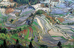
s one may make relative small (possibly circular) basins around the trees. Basin irrigation can be used both in flat areas and sloping lands. In the latter case, terraces have to be made. The spectacular terraces pictured were made by hand, a tedious job, and they are an amazing world heritage. RiceRiceRice is the seed of the monocot plants Oryza sativa or Oryza glaberrima . As a cereal grain, it is the most important staple food for a large part of the world's human population, especially in East Asia, Southeast Asia, South Asia, the Middle East, and the West Indies...
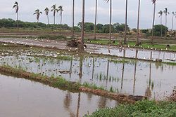
grown in the flooded basins of terraces (paddiesPaddy fieldA paddy field is a flooded parcel of arable land used for growing rice and other semiaquatic crops. Paddy fields are a typical feature of rice farming in east, south and southeast Asia. Paddies can be built into steep hillsides as terraces and adjacent to depressed or steeply sloped features such...
) is often irrigated continuously whereby the water flows from one field to the other, making sure that the rice plants remain submerged. The main reason of the submergence is weed controlWeed controlWeed control is the botanical component of pest control, using physical and chemical methods to stop weeds from reaching a mature stage of growth when they could be harmful to domesticated plants and livestock...
, but the rice needs to be of a variety that tolerates waterloggingWaterloggingWaterlogging or water logging may refer to:* Waterlogging , saturation of the soil by groundwater sufficient to prevent or hinder agriculture...
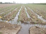
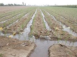
. - furrow irrigation, in which the water moves over the field in furrows between ridges on which the crop is planted. The water infiltrates into the soil from the furrows. The furrows can be made both in sloping and flat land. In steep sloping land they are preferably laid out at a mild slope at an angle with the topographic contour lineContour lineA contour line of a function of two variables is a curve along which the function has a constant value. In cartography, a contour line joins points of equal elevation above a given level, such as mean sea level...
s to avoid soil erosion.
The first four forms of irrigation come in the category of flood-irrigation, because the entire surface of the cropped area is wetted, whereas with furrow irrigation, the surface of the ridges remain dry.
The irrigation of sloping fields is called flow irrigation as the water on the surface does not come to a stand still and the stream entering the field has to be cut back before the wetting front reaches the end of the field to avoid runoff losses.
Areal growth
From 1955 to 1975 the annual growth of the irrigated area was almost 3%. From 1970 to 1982 the growth rate was some 2% per year, and from 1983 to 1994 about 1.3% per year. The growth rate of irrigated area is decreasing.The following table shows the irrigation development in the world between 1955 to 1983, distinguishing developed from developing countries:
| 1955 | 1983 | Increase | ||||
| 106 ha | % of WT | 106 ha | % of WT | 106 ha | % of 1955 | |
| Developed countries | 28 | 23 | 61 | 29 | 33 | 118 |
| Developing countries | 93 | 77 | 152 | 71 | 59 | 63 |
| World total (WT) | 121 | 100 | 213 | 100 | 92 | 76 |
| India+Pakistan | 33 | 27 | 55 | 26 | 22 | 67 |
| China | 31 | 26 | 45 | 21 | 14 | 45 |
The developed countries witnessed a relatively greater increase than the developing nations.
Water use
Irrigation schemes in the world use about 3 500 km3 water per year, of which 74% is evaporated by the crops. This is some 80% of all water used by mankind (4 400 km3 per year).The water used for irrigation is roughly 25% of the annually available water resources (14 000 km3) and 9 % of all annual river discharges in the hydrological cycle.
River discharges occur for the major part in regions with humid climates, far removed from the regions with (semi)arid climates, where irrigation water is most needed. Compared to the 8 600 km3 of annual river discharge in the drier climates only, the yearly water use for irrigation is 40%
| irrigation use |
all uses | usable resources |
total supply | |
| Quantity of water in km3/year | 3 500 | 4 400 | 14 000 | 40 000 |
| Irrigation as a percentage (%) | 100 | 80 | 25 | 9 |
Of the total irrigated area worldwide 38% is equipped for irrigation with groundwater, especially in India (39 million ha), China (19 million ha) and the United States of America (17 million ha). Total consumptive groundwater use for irrigation is estimated as 545 km3/year. Groundwater use in irrigation leads in places to exploitation of groundwater at rates above groundwater recharge and depletion of groundwater reservoirs.

